The M15 postcode district is a postal district located in the M Manchester postcode area with a population of 26,213 residents according to the 2021 England and Wales Census.
The area of the M15 postcode district is 1.13 square miles which is 2.93 square kilometres or 723.97 acres.
Currently, the M15 district has about 571 postcode units spread across 3 geographic postcode sectors.
Given that each sector allows for 400 unique postcode combinations, the district has a capacity of 1,200 postcodes. With 571 postcodes already in use, this leaves 629 units available.
The largest settlement in the M15 postal code is MANCHESTER followed by Hulme, and Manchester Science Park.
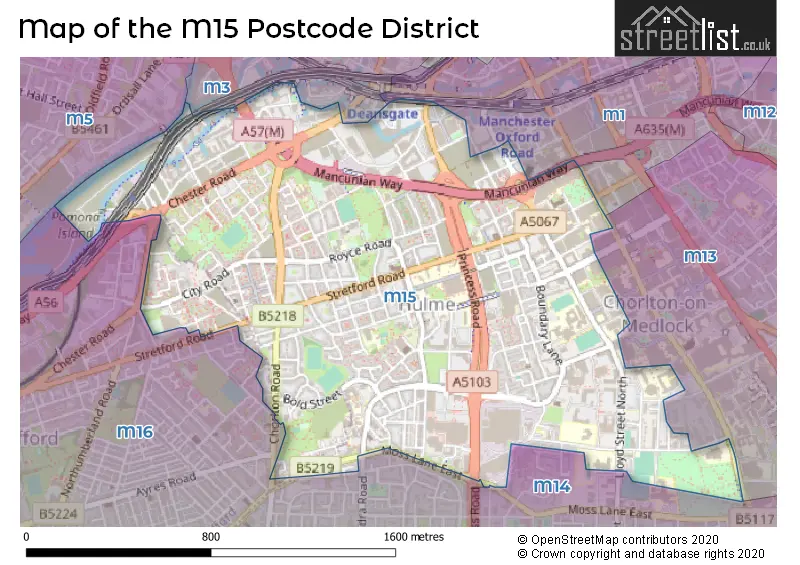
The M15 Postcode shares a border with M3 (SALFORD, MANCHESTER), M16 (MANCHESTER, Old Trafford, Whalley Range), M1 (MANCHESTER), M13 (MANCHESTER) and M14 (MANCHESTER, Fallowfield).
The primary settlement in the M15 postcode district is Manchester. Other significant settlements include Hulme and Manchester Science Park. The M15 postcode district is located in Greater Manchester in England. The main post town in the district is Manchester.
For the district M15, we have data on 3 postcode sectors. Here's a breakdown: The sector M15 4, covers Manchester in Greater Manchester. The sector M15 5, covers Manchester and Hulme in Greater Manchester. The sector M15 6, covers Manchester in Greater Manchester.


Map of the M15 Postcode District
Explore the M15 postcode district by using our free interactive map.
When it comes to local government, postal geography often disregards political borders. However, for a breakdown in the M15 District: the district mostly encompasses the Manchester District (B) (544 postcodes), and finally, the Trafford District (B) area (63 postcodes).
Recent House Sales in M15
| Date | Price | Address |
|---|---|---|
| 02/10/2023 | £170,500 | Stretford Road, Manchester, M15 5JH |
| 25/09/2023 | £185,000 | Ellesmere Street, Manchester, M15 4QQ |
| 15/09/2023 | £218,000 | Ellesmere Street, Manchester, M15 4QR |
| 13/09/2023 | £183,000 | Boundary Lane, Manchester, M15 6JN |
| 08/09/2023 | £388,000 | Silvercroft Street, Manchester, M15 4ZD |
| 06/09/2023 | £145,000 | Grenham Avenue, Manchester, M15 4HD |
| 04/09/2023 | £269,000 | Chester Road, Manchester, M15 4ZG |
| 01/09/2023 | £294,000 | Worsley Street, Manchester, M15 4NY |
| 25/08/2023 | £182,000 | Little Peter Street, Manchester, M15 4QH |
| 25/08/2023 | £185,000 | Ellesmere Street, Manchester, M15 4QQ |
Weather Forecast for M15
Press Button to Show Forecast for Manchester Youth Hostel
| Time Period | Icon | Description | Temperature | Rain Probability | Wind |
|---|---|---|---|---|---|
| 00:00 to 03:00 | Partly cloudy (night) | 5.0°C (feels like 3.0°C) | 5.00% | ENE 7 mph | |
| 03:00 to 06:00 | Partly cloudy (night) | 4.0°C (feels like 2.0°C) | 1.00% | ENE 4 mph | |
| 06:00 to 09:00 | Sunny day | 4.0°C (feels like 2.0°C) | 1.00% | ENE 4 mph | |
| 09:00 to 12:00 | Partly cloudy (day) | 7.0°C (feels like 6.0°C) | 2.00% | ENE 4 mph | |
| 12:00 to 15:00 | Overcast | 9.0°C (feels like 8.0°C) | 9.00% | ENE 4 mph | |
| 15:00 to 18:00 | Cloudy | 10.0°C (feels like 10.0°C) | 8.00% | E 4 mph | |
| 18:00 to 21:00 | Cloudy | 10.0°C (feels like 9.0°C) | 7.00% | NE 4 mph | |
| 21:00 to 00:00 | Partly cloudy (night) | 6.0°C (feels like 4.0°C) | 4.00% | ENE 7 mph |
Press Button to Show Forecast for Manchester Youth Hostel
| Time Period | Icon | Description | Temperature | Rain Probability | Wind |
|---|---|---|---|---|---|
| 00:00 to 03:00 | Partly cloudy (night) | 4.0°C (feels like 2.0°C) | 6.00% | ENE 4 mph | |
| 03:00 to 06:00 | Partly cloudy (night) | 3.0°C (feels like 1.0°C) | 6.00% | ENE 4 mph | |
| 06:00 to 09:00 | Partly cloudy (day) | 5.0°C (feels like 3.0°C) | 6.00% | ENE 4 mph | |
| 09:00 to 12:00 | Cloudy | 8.0°C (feels like 6.0°C) | 8.00% | E 7 mph | |
| 12:00 to 15:00 | Overcast | 10.0°C (feels like 9.0°C) | 16.00% | E 7 mph | |
| 15:00 to 18:00 | Cloudy | 11.0°C (feels like 9.0°C) | 18.00% | ENE 9 mph | |
| 18:00 to 21:00 | Cloudy | 10.0°C (feels like 8.0°C) | 15.00% | ENE 9 mph | |
| 21:00 to 00:00 | Cloudy | 7.0°C (feels like 5.0°C) | 17.00% | NE 9 mph |
Press Button to Show Forecast for Manchester Youth Hostel
| Time Period | Icon | Description | Temperature | Rain Probability | Wind |
|---|---|---|---|---|---|
| 00:00 to 03:00 | Cloudy | 6.0°C (feels like 4.0°C) | 16.00% | NE 9 mph | |
| 03:00 to 06:00 | Cloudy | 6.0°C (feels like 4.0°C) | 17.00% | NNE 9 mph | |
| 06:00 to 09:00 | Cloudy | 7.0°C (feels like 4.0°C) | 20.00% | NNE 9 mph | |
| 09:00 to 12:00 | Light rain | 8.0°C (feels like 5.0°C) | 50.00% | NNE 11 mph | |
| 12:00 to 15:00 | Heavy rain | 9.0°C (feels like 6.0°C) | 76.00% | N 11 mph | |
| 15:00 to 18:00 | Light rain | 10.0°C (feels like 7.0°C) | 57.00% | NNE 9 mph | |
| 18:00 to 21:00 | Cloudy | 10.0°C (feels like 8.0°C) | 18.00% | N 9 mph | |
| 21:00 to 00:00 | Partly cloudy (night) | 8.0°C (feels like 6.0°C) | 10.00% | NW 7 mph |
Where is the M15 Postcode District?
The postcode district M15 is located in Manchester, which is a district town. It is situated in the North West region. The nearby towns and their distances from M15 are as follows: Salford (2.31 miles), Sale (4.43 miles), Cheadle (5.51 miles), Stockport (5.51 miles), Dukinfield (7.01 miles), and Oldham (8.07 miles). Additionally, M15 is approximately 162.34 miles away from the center of London.
The district is within the post town of MANCHESTER.
The sector has postcodes within the nation of England.
The M15 Postcode District is covers the following regions.
- Greater Manchester South West - Greater Manchester - North West (England)
- Manchester - Greater Manchester - North West (England)
| Postcode Sector | Delivery Office |
|---|---|
| M15 4 | South West (m) Delivery Office |
| M15 5 | South West (m) Delivery Office |
| M15 6 | South West (m) Delivery Office |
| M | 1 | 5 | - | X | X | X |
| M | 1 | 5 | Space | Numeric | Letter | Letter |
Current Monthly Rental Prices
| # Bedrooms | Min Price | Max Price | Avg Price |
|---|---|---|---|
| £180 | £200 | £190 | |
| 1 | £925 | £1,600 | £1,149 |
| 2 | £995 | £2,600 | £1,734 |
| 3 | £1,400 | £12,500 | £3,246 |
| 4 | £1,700 | £12,500 | £6,150 |
Current House Prices
| # Bedrooms | Min Price | Max Price | Avg Price |
|---|---|---|---|
| £145,000 | £145,000 | £145,000 | |
| 1 | £90,000 | £330,000 | £207,652 |
| 2 | £132,500 | £650,000 | £275,439 |
| 3 | £150,000 | £2,500,000 | £506,744 |
| 4 | £250,000 | £340,000 | £295,000 |
Estate Agents who Operate in the M15 District
| Logo | Name | Brand Name | Address | Contact Number | Total Properties |
|---|---|---|---|---|---|
 | Manchester Southern Gateway | Thornley Groves | 25 Whitworth Street West, Manchester, M1 5ND | 0161 241 5875 | 29 |
 | Manchester | North Property Group | 59 Mosley Street, Manchester, M2 3HZ | 0161 524 6212 | 28 |
 | Manchester | Settio Property Experience Ltd | Northspring Building, 70 Spring Gardens, Manchester, M2 2BQ | 0161 524 0837 | 22 |
 | Liverpool | Elite Realty Invest | Suite 222B 2nd Floor, Cotton Exchange Building, Bixteth Street Liverpool L3 9JR | 0151 453 2241 | 16 |
 | Hulme Manchester | C & R Properties Ltd | Meridian Square Stretford Road Hulme Manchester M15 5JH | 0161 524 4976 | 15 |
| Type of Property | 2018 Average | 2018 Sales | 2017 Average | 2017 Sales | 2016 Average | 2016 Sales | 2015 Average | 2015 Sales |
|---|---|---|---|---|---|---|---|---|
| Detached | £197,225 | 4 | £185,625 | 4 | £150,500 | 6 | £182,000 | 1 |
| Semi-Detached | £185,871 | 12 | £157,946 | 14 | £163,450 | 12 | £150,000 | 7 |
| Terraced | £298,649 | 79 | £168,517 | 44 | £163,273 | 45 | £160,862 | 37 |
| Flats | £187,424 | 338 | £175,231 | 346 | £162,950 | 479 | £149,368 | 440 |