The M8 postcode district is a postal district located in the M Manchester postcode area with a population of 36,234 residents according to the 2021 England and Wales Census.
The area of the M8 postcode district is 2.37 square miles which is 6.13 square kilometres or 1,514.55 acres.
Currently, the M8 district has about 793 postcode units spread across 5 geographic postcode sectors.
Given that each sector allows for 400 unique postcode combinations, the district has a capacity of 2,000 postcodes. With 793 postcodes already in use, this leaves 1207 units available.
The largest settlements in the M8 postal code are MANCHESTER and Crumpsall.
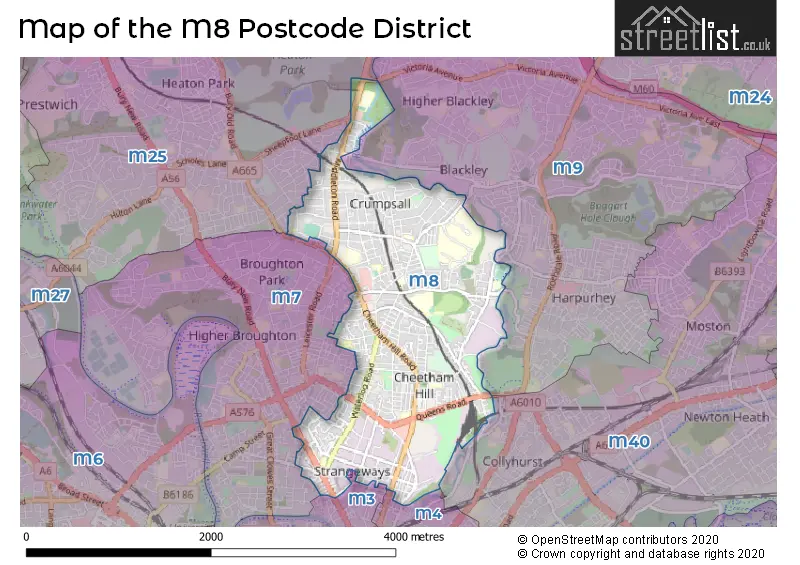
The M8 Postcode shares a border with M25 (Prestwich), M40 (MANCHESTER, Moston), M7 (SALFORD), M3 (SALFORD, MANCHESTER) and M9 (MANCHESTER).
The primary settlement in the M8 postcode district is Manchester, which is located in the county of Greater Manchester in England. Other significant settlements include Crumpsall. The main post town in this district is also Manchester.
For the district M8, we have data on 6 postcode sectors. Here's a breakdown: The sector M8 0, covers Manchester in Greater Manchester. The sector M8 2 is non-geographic. It's often designated for PO Boxes, large organisations, or special services. The sector M8 4, covers Manchester in Greater Manchester. The sector M8 5, covers Manchester in Greater Manchester. The sector M8 8, covers Manchester in Greater Manchester. The sector M8 9, covers Manchester in Greater Manchester.


Map of the M8 Postcode District
Explore the M8 postcode district by using our free interactive map.
When it comes to local government, postal geography often disregards political borders. However, for a breakdown in the M8 District: the district mostly encompasses the Manchester District (B) (791 postcodes), followed by the Bury District (B) area (9 postcodes), and finally, the Salford District (B) area (4 postcodes).
Recent House Sales in M8
| Date | Price | Address |
|---|---|---|
| 03/10/2023 | £210,000 | Cheetham Hill Road, Manchester, M8 0SN |
| 19/09/2023 | £200,000 | Whitebarn Avenue, Manchester, M8 0JT |
| 18/09/2023 | £310,000 | Cedric Road, Manchester, M8 4JE |
| 15/09/2023 | £140,000 | Faraday Avenue, Manchester, M8 0SS |
| 12/09/2023 | £183,000 | Ansdell Street, Manchester, M8 0WA |
| 07/09/2023 | £145,000 | Woodlands Street, Manchester, M8 9LL |
| 05/09/2023 | £40,000 | St Marys Hall Road, Manchester, M8 5DZ |
| 04/09/2023 | £500,000 | Fairy Lane, Manchester, M8 8DD |
| 04/09/2023 | £134,722 | Birkdale Street, Manchester, M8 0WE |
| 30/08/2023 | £165,000 | Edson Road, Manchester, M8 4WF |
Where is the M8 Postcode District?
The data you provided indicates that the postcode district M8 is located in MANCHESTER. MANCHESTER is situated in close proximity to several nearby towns. To the South West, there is SALFORD, which is approximately 2.22 miles away. To the North, you will find HEYWOOD, which is about 5.39 miles away. Towards the East, there is OLDHAM, located approximately 6.07 miles away. Lastly, to the South East, STOCKPORT is located about 7.62 miles away. It is important to note that the distance between MANCHESTER and the centre of London is 164.55 miles.
The district covers the post towns of MANCHESTER, SALFORD.
The sector has postcodes within the nation of England.
The M8 Postcode District is covers the following regions.
- Manchester - Greater Manchester - North West (England)
- Greater Manchester South West - Greater Manchester - North West (England)
- Greater Manchester North East - Greater Manchester - North West (England)
Weather Forecast for M8
Press Button to Show Forecast for Higher Broughton
| Time Period | Icon | Description | Temperature | Rain Probability | Wind |
|---|---|---|---|---|---|
| 21:00 to 00:00 | Partly cloudy (night) | 14.0°C (feels like 14.0°C) | 6.00% | NE 7 mph |
Press Button to Show Forecast for Higher Broughton
| Time Period | Icon | Description | Temperature | Rain Probability | Wind |
|---|---|---|---|---|---|
| 00:00 to 03:00 | Partly cloudy (night) | 12.0°C (feels like 11.0°C) | 0.00% | NE 7 mph | |
| 03:00 to 06:00 | Partly cloudy (night) | 10.0°C (feels like 9.0°C) | 0.00% | NE 7 mph | |
| 06:00 to 09:00 | Partly cloudy (day) | 11.0°C (feels like 9.0°C) | 1.00% | NE 11 mph | |
| 09:00 to 12:00 | Partly cloudy (day) | 14.0°C (feels like 11.0°C) | 0.00% | NE 16 mph | |
| 12:00 to 15:00 | Partly cloudy (day) | 19.0°C (feels like 15.0°C) | 0.00% | ENE 16 mph | |
| 15:00 to 18:00 | Cloudy | 19.0°C (feels like 16.0°C) | 4.00% | ENE 13 mph | |
| 18:00 to 21:00 | Partly cloudy (day) | 16.0°C (feels like 14.0°C) | 3.00% | ENE 11 mph | |
| 21:00 to 00:00 | Cloudy | 12.0°C (feels like 11.0°C) | 4.00% | NE 9 mph |
Press Button to Show Forecast for Higher Broughton
| Time Period | Icon | Description | Temperature | Rain Probability | Wind |
|---|---|---|---|---|---|
| 00:00 to 03:00 | Cloudy | 11.0°C (feels like 10.0°C) | 8.00% | NE 7 mph | |
| 03:00 to 06:00 | Overcast | 11.0°C (feels like 11.0°C) | 9.00% | NE 2 mph | |
| 06:00 to 09:00 | Overcast | 11.0°C (feels like 11.0°C) | 12.00% | NNE 2 mph | |
| 09:00 to 12:00 | Overcast | 12.0°C (feels like 12.0°C) | 21.00% | NNW 4 mph | |
| 12:00 to 15:00 | Light rain | 13.0°C (feels like 12.0°C) | 55.00% | NW 7 mph | |
| 15:00 to 18:00 | Overcast | 14.0°C (feels like 12.0°C) | 20.00% | W 7 mph | |
| 18:00 to 21:00 | Light rain | 13.0°C (feels like 11.0°C) | 52.00% | W 7 mph | |
| 21:00 to 00:00 | Light rain | 12.0°C (feels like 11.0°C) | 49.00% | WSW 4 mph |
Press Button to Show Forecast for Higher Broughton
| Time Period | Icon | Description | Temperature | Rain Probability | Wind |
|---|---|---|---|---|---|
| 00:00 to 03:00 | Light rain | 11.0°C (feels like 10.0°C) | 49.00% | SW 4 mph | |
| 03:00 to 06:00 | Light rain | 10.0°C (feels like 9.0°C) | 47.00% | SSW 4 mph | |
| 06:00 to 09:00 | Overcast | 10.0°C (feels like 9.0°C) | 16.00% | S 7 mph | |
| 09:00 to 12:00 | Overcast | 12.0°C (feels like 11.0°C) | 11.00% | SSW 7 mph | |
| 12:00 to 15:00 | Cloudy | 14.0°C (feels like 13.0°C) | 10.00% | SSW 7 mph | |
| 15:00 to 18:00 | Cloudy | 15.0°C (feels like 14.0°C) | 11.00% | SW 7 mph | |
| 18:00 to 21:00 | Overcast | 14.0°C (feels like 14.0°C) | 14.00% | SW 4 mph | |
| 21:00 to 00:00 | Cloudy | 12.0°C (feels like 11.0°C) | 8.00% | NW 4 mph |
Press Button to Show Forecast for Higher Broughton
| Time Period | Icon | Description | Temperature | Rain Probability | Wind |
|---|---|---|---|---|---|
| 00:00 to 03:00 | Partly cloudy (night) | 11.0°C (feels like 10.0°C) | 5.00% | NW 4 mph | |
| 03:00 to 06:00 | Cloudy | 10.0°C (feels like 9.0°C) | 10.00% | ENE 4 mph | |
| 06:00 to 09:00 | Cloudy | 11.0°C (feels like 10.0°C) | 9.00% | ENE 4 mph | |
| 09:00 to 12:00 | Cloudy | 13.0°C (feels like 12.0°C) | 9.00% | SE 7 mph | |
| 12:00 to 15:00 | Cloudy | 15.0°C (feels like 13.0°C) | 13.00% | SE 7 mph | |
| 15:00 to 18:00 | Cloudy | 16.0°C (feels like 15.0°C) | 16.00% | SE 4 mph | |
| 18:00 to 21:00 | Partly cloudy (day) | 14.0°C (feels like 13.0°C) | 14.00% | W 7 mph | |
| 21:00 to 00:00 | Partly cloudy (night) | 12.0°C (feels like 11.0°C) | 9.00% | N 7 mph |
| Postcode Sector | Delivery Office |
|---|---|
| M8 0 | Manchester North Delivery Office |
| M8 4 | Manchester North Delivery Office |
| M8 5 | Manchester North Delivery Office |
| M8 8 | Manchester North Delivery Office |
| M8 9 | Manchester North Delivery Office |
| M | 8 | - | X | X | X |
| M | 8 | Space | Numeric | Letter | Letter |
Tourist Attractions within the Postcode Area
We found 1 visitor attractions within the M8 postcode area
| Museum of Transport Greater Manchester |
|---|
| Museums & Art Galleries |
| Museum and / or Art Gallery |
| View Museum of Transport Greater Manchester on Google Maps |
Current Monthly Rental Prices
| # Bedrooms | Min Price | Max Price | Avg Price |
|---|---|---|---|
| 1 | £600 | £800 | £670 |
| 2 | £1,000 | £1,700 | £1,350 |
| 3 | £1,100 | £1,600 | £1,363 |
| 4 | £1,500 | £1,500 | £1,500 |
Current House Prices
| # Bedrooms | Min Price | Max Price | Avg Price |
|---|---|---|---|
| £295,000 | £295,000 | £295,000 | |
| 1 | £45,000 | £50,000 | £46,250 |
| 2 | £90,000 | £185,000 | £148,333 |
| 3 | £180,000 | £475,000 | £275,636 |
| 4 | £290,000 | £500,000 | £409,158 |
| 5 | £450,000 | £450,000 | £450,000 |
| 6 | £425,000 | £650,000 | £537,500 |
| 7 | £650,000 | £650,000 | £650,000 |
Estate Agents who Operate in the M8 District
| Logo | Name | Brand Name | Address | Contact Number | Total Properties |
|---|---|---|---|---|---|
 | Prestwich | Normie Sales & Lettings | 503-505 Bury New Road, Prestwich, Manchester M25 1AD | 020 3834 7844 | 7 |
 | Manchester | Bridgfords | The Hacienda, 21 Albion Street, Manchester, M1 5DA | 0161 524 4219 | 5 |
 | Middleton | Ryder & Dutton | 33 Middleton Gardens, Middleton, M24 1AB | 0161 524 3293 | 4 |
 | covering Manchester | Purplebricks | Suite 7 First Floor Cranmore Drive Shirley Solihull B90 4RZ | 0161 524 9265 | 3 |
 | Prestwich | Aubrey Lee & Co | 39, Bury New Road, Prestwich, Manchester, M25 9JY | 0161 524 4805 | 3 |
| Type of Property | 2018 Average | 2018 Sales | 2017 Average | 2017 Sales | 2016 Average | 2016 Sales | 2015 Average | 2015 Sales |
|---|---|---|---|---|---|---|---|---|
| Detached | £244,500 | 11 | £228,996 | 14 | £215,925 | 14 | £216,359 | 11 |
| Semi-Detached | £178,832 | 111 | £172,069 | 128 | £141,746 | 120 | £130,825 | 94 |
| Terraced | £114,317 | 124 | £101,603 | 125 | £109,635 | 122 | £87,812 | 128 |
| Flats | £91,351 | 70 | £80,415 | 57 | £69,870 | 89 | £65,495 | 76 |