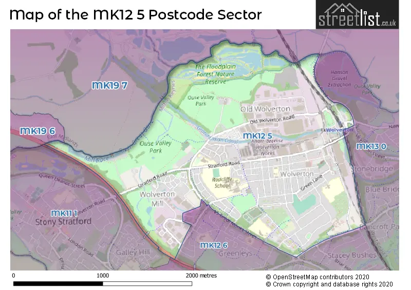
The MK12 5 postcode sector stands on the Buckinghamshire and Northamptonshire border.
Did you know? According to the 2021 Census, the MK12 5 postcode sector is home to a bustling 9,474 residents!
Given that each sector allows for 400 unique postcode combinations. Letters C, I, K, M, O and V are not allowed in the last two letters of a postcode. With 211 postcodes already in use, this leaves 189 units available.
The largest settlement in the MK12 5 postal code is Wolverton followed by Old Wolverton, and Wolverton Mill.
The MK12 5 Postcode shares a border with MK19 6 (Deanshanger, Old Stratford, Wicken), MK19 7 (Hanslope, Castlethorpe, Cosgrove), MK13 0 (New Bradwell, Bancroft, Blue Bridge), MK11 2 (Fullers Slade), MK11 1 (Stony Stratford) and MK12 6 (Greenleys, Stacey Bushes, Hodge Lea).
The sector is within the post town of MILTON KEYNES.
MK12 5 is a postcode sector within the MK12 postcode district which is within the MK Milton Keynes postcode area.
The Royal Mail delivery office for the MK12 5 postal sector is the Kiln Farm Delivery Office.
The area of the MK12 5 postcode sector is 1.84 square miles which is 4.78 square kilometres or 1,180.02 square acres.
The MK12 5 postcode sector is crossed by the A5 Major A road.
Waterways within the MK12 5 postcode sector include the Grand Union Canal.

Map of the MK12 5 Postcode Sector
Explore the MK12 5 postcode sector by using our free interactive map.
| M | K | 1 | 2 | - | 5 | X | X |
| M | K | 1 | 2 | Space | 5 | Letter | Letter |
Official List of Streets
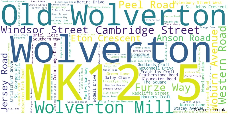
Wolverton (63 Streets)
Wolverton Mill (20 Streets)
Old Wolverton (15 Streets)
Unofficial Streets or Alternative Spellings
Stacey Bushes
BRIAR HILL WHITE ALDER CANNON HARNETT COURT FITZHAMMON COURT GRAFTON STREET GREAT MONKS STREET GREENLEYS LANE HAVERSHAM ROUNDABOUT MANGO WAY MANOR FARM LANE MCCORQUODALE PLACE MCCORQUORDALE ROAD MILL COURT MILL SQUARE MILL TERRACE MILLERS WAY OSBOURNE STREET RIDGEWAY SLATED ROW STONEBRIDGE ROUNDABOUT TWISLETON HEATH V5 GREAT MONKS STREET V6 GRAFTON STREET WOLVERTON ROADNew Bradwell
NEWPORT ROADWolverton Mill
FITZHAMON COURTGreenleys
FIELD LANE OXMAN LANESchools and Places of Education Within the MK12 5 Postcode Sector
Bushfield School
Foundation school
Moon Street, Milton Keynes, Buckinghamshire, MK12 5JG
Head: Mr Steve Springett-McHugh
Ofsted Rating: Good
Inspection: 2022-03-10 (805 days ago)
Website: Visit Bushfield School Website
Phone: 01908314876
Number of Pupils: 413
Greenleys Junior School
Community school
Marron Lane, Milton Keynes, Buckinghamshire, MK12 5DE
Head: Mr Mike Talbot
Ofsted Rating: Good
Inspection: 2023-06-21 (337 days ago)
Website: Visit Greenleys Junior School Website
Phone: 01908312551
Number of Pupils: 225
Slated Row School
Community special school
Old Wolverton Road, Milton Keynes, Buckinghamshire, MK12 5NJ
Head: Mr Jonathan Budd
Ofsted Rating: Outstanding
Inspection: 2023-11-16 (189 days ago)
Website: Visit Slated Row School Website
Phone: 01908316017
Number of Pupils: 226
The Radcliffe School
Foundation school
Christchurch Grove, Milton Keynes, Buckinghamshire, MK12 5BT
Head: Paula Lawson
Ofsted Rating: Good
Inspection: 2020-01-29 (1576 days ago)
Website: Visit The Radcliffe School Website
Phone: 01908682222
Number of Pupils: 1223
Wyvern School
Foundation school
Aylesbury Street, Milton Keynes, Buckinghamshire, MK12 5HU
Head: Mr Steve Springett-McHugh
Ofsted Rating: Good
Inspection: 2019-05-09 (1841 days ago)
Website: Visit Wyvern School Website
Phone: 01908312275
Number of Pupils: 328
House Prices in the MK12 5 Postcode Sector
| Type of Property | 2018 Average | 2018 Sales | 2017 Average | 2017 Sales | 2016 Average | 2016 Sales | 2015 Average | 2015 Sales |
|---|---|---|---|---|---|---|---|---|
| Detached | £360,250 | 10 | £336,111 | 9 | £345,762 | 15 | £283,057 | 14 |
| Semi-Detached | £275,523 | 45 | £259,811 | 46 | £262,398 | 35 | £229,523 | 21 |
| Terraced | £243,230 | 93 | £243,139 | 105 | £232,950 | 111 | £196,682 | 100 |
| Flats | £148,340 | 25 | £147,026 | 48 | £149,949 | 42 | £143,630 | 33 |
Important Postcodes MK12 5 in the Postcode Sector
MK12 5BT is the postcode for SPORTS BLOCK, The Radcliffe School, Aylesbury Street West, The Radcliffe School, Aylesbury Street West, Wolverton, and The Radcliffe School, Aylesbury Street West
MK12 5DE is the postcode for Greenleys Junior School, Marron Lane, Greenleys Junior School, Marron Lane, Wolverton, and GREENLEY JUNIOR SCHOOL, Greenleys County Middle School, Marron Lane
MK12 5DF is the postcode for Wolverton Health Centre, Gloucester Road
MK12 5HU is the postcode for Wyvern County First School, Aylesbury Street, Wolverton, Wyvern School, Aylesbury Street, WOLVERTON DAY NURSERY WYVERN FIRST SCHOOL, Wyvern County First School, Aylesbury Street, and Wyvern County First School, Aylesbury Street
MK12 5JG is the postcode for Bushfield School, Moon Street, Wolverton, NEW CLASSROOM BLOCK, Bushfield School, Moon Street, and Bushfield School, Moon Street
MK12 5LX is the postcode for Thames Valley Police, Stratford Road
MK12 5LY is the postcode for Town Hall, Creed Street
MK12 5NJ is the postcode for Slated Row Special School, Old Wolverton Road, Slated Row, Old Wolverton, and Slated Row Special School, Old Wolverton Road, Slated Row
MK12 5QF is the postcode for Colossus, 9 Dickens Road
MK12 5RL is the postcode for Old Bath House & Community Centre, 205 Stratford Road
MK12 5TN is the postcode for Millmead Hall Ltd, Haversham Road
| The MK12 5 Sector is within these Local Authorities |
|
|---|---|
| The MK12 5 Sector is within these Counties |
|
| The MK12 5 Sector is within these Water Company Areas |
|
Tourist Attractions within the MK12 5 Postcode Area
We found 1 visitor attractions within the MK12 postcode area
| Milton Keynes Museum |
|---|
| Museums & Art Galleries |
| Museum and / or Art Gallery |
| View Milton Keynes Museum on Google Maps |