
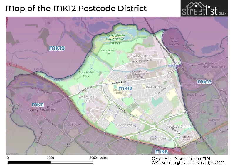
Map of the Postcode District
Explore the postcode district by using our interactive map.
Circles represent recorded crime; the larger the circle, the higher the crime rates.
Your support helps keep this site running!
If you enjoy using this website, consider buying me a coffee to help cover hosting costs.
The postcode district located in the MK Milton Keynes postal area , MK12 has a population of 14,487 residents according to the 2021 England and Wales Census.
The area of the district is 2.39 square miles (6.18 square kilometers or 1,527.69 acres).
Where is the MK12 District?
To give you an idea where the district is located we have created the following table showing nearby towns.
Nearest Towns to MK12
| Town | Distance (miles) | Direction |
|---|---|---|
| Milton Keynes | 3.05 | ESE |
| Newport Pagnell | 4.53 | ENE |
| Bletchley | 5.81 | SE |
| Woburn Sands | 7.87 | ESE |
| Buckingham | 8.22 | WSW |
| Olney | 8.39 | NE |
| Winslow | 8.66 | SSW |
| Towcester | 8.72 | NW |
| Woburn | 9.90 | ESE |
| Leighton Buzzard | 12.04 | SE |
| Northampton | 12.67 | NNW |
| Brackley | 13.95 | W |
| Ampthill | 14.06 | E |
| Kempston | 14.12 | ENE |
| Flitwick | 14.39 | ESE |
| Wixams | 15.44 | E |
| Bedford | 15.85 | ENE |
| Houghton Regis | 16.69 | SE |
| Aylesbury | 16.84 | S |
| Dunstable | 17.42 | SE |
The post town for this district is MILTON KEYNES.
Postcode Information for District MK12 (Total Geographical Postcodes: 320)
| Location | Post Town | Sector | Number of Postcodes |
|---|---|---|---|
| Wolverton | MILTON KEYNES | MK12 5 | 169 |
| Old Wolverton | MILTON KEYNES | MK12 5 | 35 |
| Greenleys | MILTON KEYNES | MK12 6 | 33 |
| Wolverton Mill | MILTON KEYNES | MK12 5 | 31 |
| Stacey Bushes | MILTON KEYNES | MK12 6 | 28 |
| Hodge Lea | MILTON KEYNES | MK12 6 | 21 |
| Wolverton Mill | MILTON KEYNES | MK12 6 | 3 |
Retail and Shopping in MK12
Street
Town
Locality
Number of Shops
Central Postcode
View on Google Maps
STRATFORD ROAD
MILTON KEYNES
WOLVERTON
54
MK12 5LJ
View on Google Maps
CHURCH STREET
MILTON KEYNES
WOLVERTON
28
MK12 5JW
View on Google Maps
RADCLIFFE STREET
MILTON KEYNES
WOLVERTON
14
MK12 5DQ
View on Google Maps
THE SQUARE
MILTON KEYNES
WOLVERTON
12
MK12 5DG
View on Google Maps
ERICA ROAD
MILTON KEYNES
STACEY BUSHES
11
MK12 6HS
View on Google Maps
GLYN SQUARE
MILTON KEYNES
WOLVERTON
8
MK12 5JQ
View on Google Maps
ARDWELL LANE
MILTON KEYNES
GREENLEYS
7
MK12 6AX
View on Google Maps
| Street | Town | Locality | Number of Shops | Central Postcode | View on Google Maps |
|---|---|---|---|---|---|
| STRATFORD ROAD | MILTON KEYNES | WOLVERTON | 54 | MK12 5LJ | View on Google Maps |
| CHURCH STREET | MILTON KEYNES | WOLVERTON | 28 | MK12 5JW | View on Google Maps |
| RADCLIFFE STREET | MILTON KEYNES | WOLVERTON | 14 | MK12 5DQ | View on Google Maps |
| THE SQUARE | MILTON KEYNES | WOLVERTON | 12 | MK12 5DG | View on Google Maps |
| ERICA ROAD | MILTON KEYNES | STACEY BUSHES | 11 | MK12 6HS | View on Google Maps |
| GLYN SQUARE | MILTON KEYNES | WOLVERTON | 8 | MK12 5JQ | View on Google Maps |
| ARDWELL LANE | MILTON KEYNES | GREENLEYS | 7 | MK12 6AX | View on Google Maps |
In the MK12 postcode district, the primary settlement is Wolverton, located in the county of Buckinghamshire in England. Other significant settlements include Old Wolverton and Greenleys. The postal town for this district is Milton Keynes.
When it comes to local government, postal geography often disregards political borders. However, this district intersects the following councils: the district mostly encompasses the Milton Keynes (B) area with a total of 295 postal codes.
The largest settlement in the MK12 postal code is Wolverton followed by Greenleys, and Stacey Bushes.
The MK12 Postcode shares a border with MK8 (Whitehouse, Two Mile Ash, Great Holm), MK11 (Stony Stratford, Fairfields, Fullers Slade), MK13 (Bradville, New Bradwell, Heelands) and MK19 (Hanslope, Deanshanger, Old Stratford).


Schools in the Sector
The Radcliffe School
Phase: Secondary
Address: Christchurch Grove , Wolverton , Milton Keynes
Postcode: MK12 5BT
Headteacher: Paula Lawson (Headteacher)
Ofsted Rating: Good
Greenleys Junior School
Phase: Primary
Address: Marron Lane , Wolverton , Milton Keynes
Postcode: MK12 5DE
Headteacher: Mr Mike Talbot (Headteacher)
Ofsted Rating: Good
Wyvern School
Phase: Primary
Address: Aylesbury Street , Wolverton , Milton Keynes
Postcode: MK12 5HU
Headteacher: Mr Steve Springett-McHugh (Headteacher)
Ofsted Rating: Good
Bushfield School
Phase: Primary
Address: Moon Street , Wolverton , Milton Keynes
Postcode: MK12 5JG
Headteacher: Mr Steve Springett-McHugh (Headteacher)
Ofsted Rating: Good
Slated Row School
Phase: Not applicable
Address: Old Wolverton Road , Wolverton , Milton Keynes
Postcode: MK12 5NJ
Headteacher: Mr Jonathan Budd (Headteacher)
Ofsted Rating: Outstanding
Greenleys First School
Phase: Primary
Address: Ardwell Lane , Greenleys , Milton Keynes
Postcode: MK12 6AT
Headteacher: Mr Douglas Campbell (Headteacher)
Ofsted Rating: Good
St Mary Magdalene Catholic Primary School
Phase: Primary
Address: Ardwell Lane , Greenleys , Milton Keynes
Postcode: MK12 6AY
Headteacher: Mrs Rosemarie Jones (Headteacher)
Ofsted Rating: Outstanding
Stations in the Sector
Wolverton
CRS Code: WOL
Operator: LN
Line: West Coast Main Line|Northampton Loop Line
Company: Grand Central North West
Accessable Motorway Junctions
M1 J14
Average Driving Time from within the district: 7.43
Average Driving Distance: 6.47
Number of Postcodes that can access the Motorway Junction: 295
M1 J13
Average Driving Time from within the district: 12.22
Average Driving Distance: 11.39
Number of Postcodes that can access the Motorway Junction: 295
M1 J15
Average Driving Time from within the district: 17.17
Average Driving Distance: 12.04
Number of Postcodes that can access the Motorway Junction: 295
M1 J12
Average Driving Time from within the district: 17.89
Average Driving Distance: 17.45
Number of Postcodes that can access the Motorway Junction: 89
M1 J15A
Average Driving Time from within the district: 19.82
Average Driving Distance: 14.84
Number of Postcodes that can access the Motorway Junction: 295
M1 J16
Average Driving Time from within the district: 23.01
Average Driving Distance: 18.10
Number of Postcodes that can access the Motorway Junction: 206
Weather Forecast for Wolverton
| Time Period | Icon | Description | Temperature | Rain Probability | Wind |
|---|---|---|---|---|---|
| 12:00 to 15:00 | Cloudy | 14.0°C (feels like 12.0°C) | 5.00% | WSW 11 mph | |
| 15:00 to 18:00 | Partly cloudy (day) | 15.0°C (feels like 14.0°C) | 4.00% | WSW 7 mph | |
| 18:00 to 21:00 | Clear night | 12.0°C (feels like 11.0°C) | 2.00% | SW 4 mph | |
| 21:00 to 00:00 | Clear night | 10.0°C (feels like 9.0°C) | 0.00% | SW 4 mph |
| Time Period | Icon | Description | Temperature | Rain Probability | Wind |
|---|---|---|---|---|---|
| 00:00 to 03:00 | Clear night | 9.0°C (feels like 8.0°C) | 1.00% | SW 4 mph | |
| 03:00 to 06:00 | Cloudy | 8.0°C (feels like 7.0°C) | 14.00% | SW 4 mph | |
| 06:00 to 09:00 | Fog | 8.0°C (feels like 7.0°C) | 15.00% | SW 4 mph | |
| 09:00 to 12:00 | Cloudy | 10.0°C (feels like 9.0°C) | 5.00% | SSW 7 mph | |
| 12:00 to 15:00 | Cloudy | 14.0°C (feels like 12.0°C) | 4.00% | SSW 9 mph | |
| 15:00 to 18:00 | Partly cloudy (day) | 15.0°C (feels like 14.0°C) | 2.00% | S 7 mph | |
| 18:00 to 21:00 | Clear night | 12.0°C (feels like 11.0°C) | 0.00% | S 7 mph | |
| 21:00 to 00:00 | Clear night | 11.0°C (feels like 9.0°C) | 0.00% | SSE 7 mph |
| Time Period | Icon | Description | Temperature | Rain Probability | Wind |
|---|---|---|---|---|---|
| 00:00 to 03:00 | Clear night | 10.0°C (feels like 8.0°C) | 1.00% | SSE 9 mph | |
| 03:00 to 06:00 | Clear night | 10.0°C (feels like 8.0°C) | 1.00% | SSE 9 mph | |
| 06:00 to 09:00 | Clear night | 10.0°C (feels like 7.0°C) | 1.00% | SSE 9 mph | |
| 09:00 to 12:00 | Cloudy | 11.0°C (feels like 9.0°C) | 4.00% | SSE 11 mph | |
| 12:00 to 15:00 | Overcast | 14.0°C (feels like 12.0°C) | 7.00% | SSE 13 mph | |
| 15:00 to 18:00 | Partly cloudy (day) | 15.0°C (feels like 13.0°C) | 2.00% | S 11 mph | |
| 18:00 to 21:00 | Cloudy | 14.0°C (feels like 12.0°C) | 5.00% | SSE 11 mph | |
| 21:00 to 00:00 | Cloudy | 14.0°C (feels like 12.0°C) | 10.00% | SSE 11 mph |
| Time Period | Icon | Description | Temperature | Rain Probability | Wind |
|---|---|---|---|---|---|
| 00:00 to 03:00 | Light rain shower (night) | 14.0°C (feels like 12.0°C) | 42.00% | S 11 mph | |
| 03:00 to 06:00 | Light rain shower (night) | 13.0°C (feels like 11.0°C) | 39.00% | SSW 11 mph | |
| 06:00 to 09:00 | Light rain shower (night) | 11.0°C (feels like 9.0°C) | 31.00% | SSW 9 mph | |
| 09:00 to 12:00 | Sunny day | 11.0°C (feels like 9.0°C) | 7.00% | SSW 11 mph | |
| 12:00 to 15:00 | Partly cloudy (day) | 13.0°C (feels like 10.0°C) | 15.00% | SW 13 mph | |
| 15:00 to 18:00 | Light rain shower (day) | 12.0°C (feels like 10.0°C) | 33.00% | SW 11 mph | |
| 18:00 to 21:00 | Partly cloudy (night) | 10.0°C (feels like 8.0°C) | 4.00% | SW 9 mph | |
| 21:00 to 00:00 | Clear night | 9.0°C (feels like 6.0°C) | 4.00% | SW 11 mph |
| Time Period | Icon | Description | Temperature | Rain Probability | Wind |
|---|---|---|---|---|---|
| 00:00 to 03:00 | Clear night | 8.0°C (feels like 5.0°C) | 3.00% | SW 9 mph | |
| 03:00 to 06:00 | Clear night | 8.0°C (feels like 5.0°C) | 4.00% | SW 11 mph | |
| 06:00 to 09:00 | Partly cloudy (night) | 8.0°C (feels like 5.0°C) | 9.00% | SSW 11 mph | |
| 09:00 to 12:00 | Partly cloudy (day) | 10.0°C (feels like 7.0°C) | 8.00% | SW 11 mph | |
| 12:00 to 15:00 | Cloudy | 12.0°C (feels like 9.0°C) | 15.00% | SW 13 mph | |
| 15:00 to 18:00 | Cloudy | 12.0°C (feels like 10.0°C) | 34.00% | SW 13 mph | |
| 18:00 to 21:00 | Cloudy | 11.0°C (feels like 9.0°C) | 10.00% | SW 11 mph | |
| 21:00 to 00:00 | Clear night | 11.0°C (feels like 9.0°C) | 7.00% | SW 11 mph |
| Postal Sector | Delivery Office |
|---|---|
| MK12 5 | Kiln Farm Delivery Office |
| MK12 6 | Kiln Farm Delivery Office |
| M | K | 1 | 2 | - | X | X | X |
| M | K | 1 | 2 | Space | Numeric | Letter | Letter |
Tourist Attractions
We found 1 visitor attractions.
| Milton Keynes Museum |
|---|
| Museums & Art Galleries |
| Museum and / or Art Gallery |
| View Milton Keynes Museum on Google Maps |
Street List for the MK12 District
Current Monthly Rental Prices
| # Bedrooms | Min Price | Max Price | Avg Price |
|---|---|---|---|
| 1 | £500 | £1,600 | £1,025 |
| 2 | £3,000 | £3,000 | £3,000 |
| 3 | £1,175 | £1,500 | £1,369 |
| 4 | £4,000 | £4,000 | £4,000 |
Current House Prices
| # Bedrooms | Min Price | Max Price | Avg Price |
|---|---|---|---|
| £100,000 | £1,200,000 | £650,000 | |
| 1 | £160,000 | £215,000 | £178,750 |
| 2 | £165,000 | £270,000 | £223,615 |
| 3 | £250,000 | £375,000 | £307,049 |
| 4 | £270,000 | £595,000 | £403,636 |
| 5 | £475,000 | £550,000 | £512,500 |
Estate Agents
| Logo | Name | Brand Name | Address | Contact Number |
|---|---|---|---|---|
 | Stony Stratford | Connells | 82 High Street Stony Stratford Milton Keynes MK11 1AH | 01908 103381 |
 | Wolverton | Avenues Estate Agents | 42 Stratford Road, Wolverton, Milton Keynes, MK12 5LW | 01908 103579 |
 | Milton Keynes | Urban & Rural Property Services | 338 Silbury Boulevard, Milton Keynes, MK9 2AE | 01908 103613 |
 | Stony Stratford | Brown & Merry | 65 High Street, Stony Stratford, Buckinghamshire, MK11 1AY | 01908 103622 |
 | Stony Stratford | Carters Estate Agents | 59 High Street, Stony Stratford, Milton Keynes, MK11 1AY | 01908 103357 |
Yearly House Price Averages for the District
| Type of Property | 2018 Average | 2018 Sales | 2017 Average | 2017 Sales | 2016 Average | 2016 Sales | 2015 Average | 2015 Sales |
|---|---|---|---|---|---|---|---|---|
| Detached | £350,000 | 13 | £312,824 | 17 | £338,671 | 20 | £269,282 | 17 |
| Semi-Detached | £266,212 | 54 | £254,628 | 53 | £252,198 | 45 | £218,269 | 26 |
| Terraced | £236,482 | 115 | £233,937 | 130 | £223,772 | 141 | £188,924 | 127 |
| Flats | £152,048 | 31 | £147,450 | 55 | £148,905 | 49 | £139,997 | 39 |