The N18 3 postcode sector is within the county of Greater London.
Did you know? According to the 2021 Census, the N18 3 postcode sector is home to a bustling 4 residents!
Given that each sector allows for 400 unique postcode combinations. Letters C, I, K, M, O and V are not allowed in the last two letters of a postcode. With 45 postcodes already in use, this leaves 355 units available.
The N18 3 postal code covers the settlement of EDMONTON .
The N18 3 Postcode shares a border with N9 0 (EDMONTON ), N17 0 (TOTTENHAM ), N18 2 (EDMONTON ), E4 8 (CHINGFORD ) and E17 5 (WALTHAMSTOW ).
The sector is within the post town of LONDON.
N18 3 is a postcode sector within the N18 postcode district which is within the N North London postcode area.
The Royal Mail delivery office for the N18 3 postal sector is the Upper Edmonton Sdelivery Office.
The area of the N18 3 postcode sector is 0.61 square miles which is 1.59 square kilometres or 392.82 square acres.
Waterways within the N18 3 postcode sector include the River Lee Navigation.

Map of the N18 3 Postcode Sector
Explore the N18 3 postcode sector by using our free interactive map.
| N | 1 | 8 | - | 3 | X | X |
| N | 1 | 8 | Space | 3 | Letter | Letter |
Official List of Streets
Enfield (17 Streets)
Unofficial Streets or Alternative Spellings
Waltham Forest
LOWER HALL LANE WALTHAMSTOW AVENUE ANGEL ROAD ANGEL ROAD (NORTH CIRCULAR ROAD) ANGEL WALK BARNES ROAD CONDUIT LANE FERRY BOAT ROUNDABOUT HAWLEY ROAD LEA VALLEY VIADUCT LEE PARK WAY NORTH CIRCULAR ROAD RIVERMEAD ROAD SILVERMERE DRIVE TOWPATH ROAD WALTHAMSTOW AVENUE (NORTH CIRCULAR ROAD)Enfield
DANIEL CLOSE MERIDIAN WAY SECOND AVENUEHaringey
LEESIDE ROAD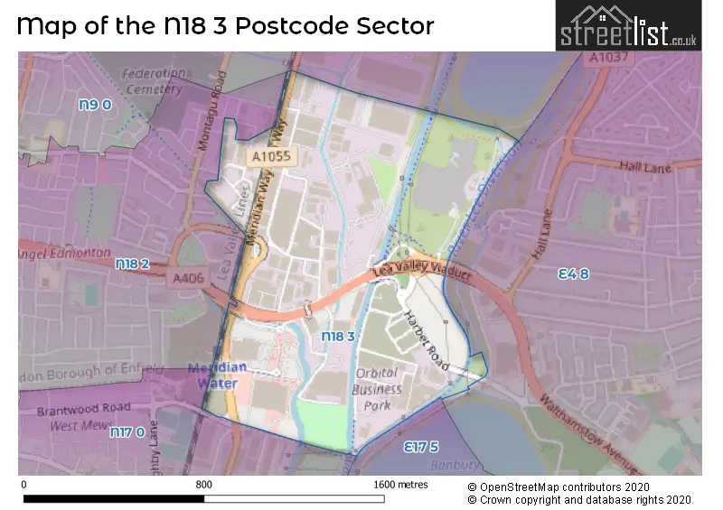
House Prices in the N18 3 Postcode Sector
| Type of Property | 2018 Average | 2018 Sales | 2017 Average | 2017 Sales | 2016 Average | 2016 Sales | 2015 Average | 2015 Sales |
|---|---|---|---|---|---|---|---|---|
| Detached | £0 | 0 | £0 | 0 | £0 | 0 | £0 | 0 |
| Semi-Detached | £0 | 0 | £0 | 0 | £0 | 0 | £0 | 0 |
| Terraced | £0 | 0 | £0 | 0 | £0 | 0 | £0 | 0 |
| Flats | £0 | 0 | £0 | 0 | £0 | 0 | £0 | 0 |
Important Postcodes N18 3 in the Postcode Sector
N18 3JR is the postcode for Driver & Vehicle Standards Agency, Unit 2
| The N18 3 Sector is within these Local Authorities |
|
|---|---|
| The N18 3 Sector is within these Counties |
|
| The N18 3 Sector is within these Water Company Areas |
|