The NE19 postcode district is a postal district located in the NE Newcastle upon Tyne postcode area with a population of 2,063 residents according to the 2021 England and Wales Census.
The area of the NE19 postcode district is 161.67 square miles which is 418.71 square kilometres or 103,465.75 acres.
Currently, the NE19 district has about 214 postcode units spread across 2 geographic postcode sectors.
Given that each sector allows for 400 unique postcode combinations, the district has a capacity of 800 postcodes. With 214 postcodes already in use, this leaves 586 units available.
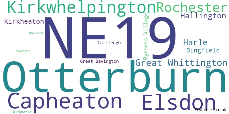
The largest settlement in the NE19 postal code is Otterburn followed by Elsdon, and Kirkwhelpington.
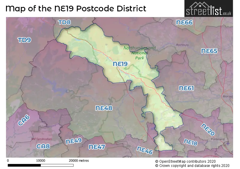
The NE19 Postcode shares a border with NE45 (CORBRIDGE, Roman Heights), NE46 (HEXHAM, Acomb, Humshaugh), NE61 (MORPETH, Pegswood, Widdrington), NE20 (Ponteland, Belsay, Matfen), NE48 (Bellingham, Wark, West Woodburn), NE65 (Amble, Rothbury, Longframlington) and TD8 (JEDBURGH, Ancrum, Lanton).
In the NE19 postcode district, the primary settlement is Elsdon, located in the county of Northumberland. Other significant settlements in this district include Otterburn, Rochester, Bingfield, Capheaton, Great Whittington, Hallington, Harle, Kirkheaton, Kirkwhelpington, and Marycastle. The most significant post town in this district is Newcastle upon Tyne.
For the district NE19, we have data on 2 postcode sectors. Here's a breakdown: The sector NE19 1, covers Otterburn and Elsdon and Rochester in Northumberland. The sector NE19 2, covers Capheaton and Kirkwhelpington and Great Whittington and Harle in Northumberland.

Map of the NE19 Postcode District
Explore the NE19 postcode district by using our free interactive map.
When it comes to local government, postal geography often disregards political borders. However, for a breakdown in the NE19 District: the district mostly encompasses the Northumberland area with a total of 216 postcodes.
Recent House Sales in NE19
| Date | Price | Address |
|---|---|---|
| 15/09/2023 | £80,000 | Otterburn, Newcastle Upon Tyne, NE19 1NP |
| 14/09/2023 | £120,000 | Brierley Gardens, Otterburn, Newcastle Upon Tyne, NE19 1HB |
| 11/08/2023 | £155,000 | South Greens, Byrness Village, Newcastle Upon Tyne, NE19 1TT |
| 28/07/2023 | £405,000 | The Larkes, Elsdon, Newcastle Upon Tyne, NE19 1AZ |
| 29/06/2023 | £175,000 | Crawford Close, Elsdon, Newcastle Upon Tyne, NE19 1AX |
| 14/06/2023 | £1,400,000 | Hallington, Newcastle Upon Tyne, NE19 2LR |
| 02/05/2023 | £515,000 | Elsdon, Newcastle Upon Tyne, NE19 1BT |
| 05/04/2023 | £226,500 | Castle Rigg, Otterburn, Newcastle Upon Tyne, NE19 1NQ |
| 24/03/2023 | £245,000 | Kirkwhelpington, Newcastle Upon Tyne, NE19 2RT |
| 14/03/2023 | £115,000 | Brierley Gardens, Otterburn, Newcastle Upon Tyne, NE19 1HB |
Where is the NE19 Postcode District?
The postcode district NE19 is located in Newcastle Upon Tyne. This district is near various towns, including Corbridge, Hexham, Haltwhistle, Morpeth, Jedburgh, Newcastleton, Wooler, and Alnwick. Additionally, NE19 is situated approximately 271.27 miles away from the center of London.
The district is within the post town of NEWCASTLE UPON TYNE.
The sector has postcodes within the nation of England.
The NE19 Postcode District is in the Northumberland region of Northumberland and Tyne and Wear within the North East (England).
Weather Forecast for NE19
Press Button to Show Forecast for Otterburn Camp
| Time Period | Icon | Description | Temperature | Rain Probability | Wind |
|---|---|---|---|---|---|
| 03:00 to 06:00 | Fog | 9.0°C (feels like 8.0°C) | 19.00% | SW 7 mph | |
| 06:00 to 09:00 | Fog | 9.0°C (feels like 8.0°C) | 18.00% | SW 7 mph | |
| 09:00 to 12:00 | Fog | 11.0°C (feels like 9.0°C) | 17.00% | WSW 7 mph | |
| 12:00 to 15:00 | Overcast | 12.0°C (feels like 11.0°C) | 15.00% | WSW 7 mph | |
| 15:00 to 18:00 | Overcast | 13.0°C (feels like 12.0°C) | 9.00% | WSW 7 mph | |
| 18:00 to 21:00 | Cloudy | 13.0°C (feels like 12.0°C) | 6.00% | WSW 7 mph | |
| 21:00 to 00:00 | Cloudy | 10.0°C (feels like 9.0°C) | 5.00% | WSW 4 mph |
Press Button to Show Forecast for Otterburn Camp
| Time Period | Icon | Description | Temperature | Rain Probability | Wind |
|---|---|---|---|---|---|
| 00:00 to 03:00 | Cloudy | 9.0°C (feels like 9.0°C) | 17.00% | WSW 2 mph | |
| 03:00 to 06:00 | Fog | 8.0°C (feels like 8.0°C) | 18.00% | W 2 mph | |
| 06:00 to 09:00 | Mist | 10.0°C (feels like 9.0°C) | 19.00% | W 2 mph | |
| 09:00 to 12:00 | Cloudy | 13.0°C (feels like 12.0°C) | 8.00% | WSW 4 mph | |
| 12:00 to 15:00 | Light rain shower (day) | 14.0°C (feels like 14.0°C) | 37.00% | NW 4 mph | |
| 15:00 to 18:00 | Heavy rain shower (day) | 14.0°C (feels like 13.0°C) | 53.00% | NE 4 mph | |
| 18:00 to 21:00 | Light rain shower (day) | 13.0°C (feels like 12.0°C) | 39.00% | NE 4 mph | |
| 21:00 to 00:00 | Cloudy | 10.0°C (feels like 10.0°C) | 9.00% | NE 2 mph |
Press Button to Show Forecast for Otterburn Camp
| Time Period | Icon | Description | Temperature | Rain Probability | Wind |
|---|---|---|---|---|---|
| 00:00 to 03:00 | Cloudy | 9.0°C (feels like 9.0°C) | 8.00% | NNE 2 mph | |
| 03:00 to 06:00 | Overcast | 9.0°C (feels like 8.0°C) | 15.00% | NE 4 mph | |
| 06:00 to 09:00 | Overcast | 9.0°C (feels like 8.0°C) | 13.00% | N 4 mph | |
| 09:00 to 12:00 | Overcast | 11.0°C (feels like 9.0°C) | 16.00% | NNE 7 mph | |
| 12:00 to 15:00 | Overcast | 12.0°C (feels like 11.0°C) | 14.00% | NE 7 mph | |
| 15:00 to 18:00 | Light rain | 13.0°C (feels like 11.0°C) | 38.00% | NE 7 mph | |
| 18:00 to 21:00 | Cloudy | 12.0°C (feels like 10.0°C) | 7.00% | ENE 7 mph | |
| 21:00 to 00:00 | Cloudy | 8.0°C (feels like 7.0°C) | 5.00% | E 4 mph |
Press Button to Show Forecast for Otterburn Camp
| Time Period | Icon | Description | Temperature | Rain Probability | Wind |
|---|---|---|---|---|---|
| 00:00 to 03:00 | Overcast | 7.0°C (feels like 6.0°C) | 10.00% | ESE 2 mph | |
| 03:00 to 06:00 | Cloudy | 7.0°C (feels like 6.0°C) | 8.00% | SSE 2 mph | |
| 06:00 to 09:00 | Overcast | 8.0°C (feels like 7.0°C) | 10.00% | SSE 2 mph | |
| 09:00 to 12:00 | Overcast | 12.0°C (feels like 11.0°C) | 8.00% | S 4 mph | |
| 12:00 to 15:00 | Cloudy | 14.0°C (feels like 13.0°C) | 5.00% | SSW 7 mph | |
| 15:00 to 18:00 | Cloudy | 15.0°C (feels like 14.0°C) | 5.00% | SW 9 mph | |
| 18:00 to 21:00 | Cloudy | 14.0°C (feels like 12.0°C) | 5.00% | SW 9 mph | |
| 21:00 to 00:00 | Cloudy | 11.0°C (feels like 9.0°C) | 6.00% | SW 7 mph |
| Postcode Sector | Delivery Office |
|---|---|
| NE19 1 | Ponteland Delivery Office |
| NE19 2 | Ponteland Delivery Office |
| N | E | 1 | 9 | - | X | X | X |
| N | E | 1 | 9 | Space | Numeric | Letter | Letter |
Current Monthly Rental Prices
| # Bedrooms | Min Price | Max Price | Avg Price |
|---|---|---|---|
| 3 | £2,250 | £2,250 | £2,250 |
| 4 | £1,200 | £1,200 | £1,200 |
Current House Prices
| # Bedrooms | Min Price | Max Price | Avg Price |
|---|---|---|---|
| £400,000 | £400,000 | £400,000 | |
| 1 | £75,000 | £75,000 | £75,000 |
| 2 | £39,950 | £250,000 | £124,793 |
| 3 | £150,000 | £475,000 | £257,217 |
| 4 | £80,000 | £475,000 | £263,333 |
| 5 | £4,000,000 | £4,000,000 | £4,000,000 |
| 18 | £2,750,000 | £2,750,000 | £2,750,000 |
Estate Agents who Operate in the NE19 District
| Logo | Name | Brand Name | Address | Contact Number | Total Properties |
|---|---|---|---|---|---|
 | Lytham | Sell My Group | The Old Bakery Green Street, Lytham, Lytham St. Annes, FY8 5LG | 020 3910 6164 | 8 |
 | Hexham | Youngs RPS | Priestpopple Hexham NE46 1PS | 01434 408829 | 4 |
 | Bedlington | Pattinson Estate Agents | 17-18 Market Place, Bedlington, NE22 5TN | 0191 625 1039 | 3 |
 | Newcastle upon Tyne | Goodfellows | 11 West Road Ponteland Newcastle upon Tyne Northumberland NE20 9SU | 01661 525170 | 3 |
 | Ponteland | Rook Matthews Sayer | Ash House Bell Villas, Ponteland, Newcastle Upon Tyne, NE20 9BE | 01661 525198 | 2 |
Yearly House Price Averages for the NE19 Postcode District
| Type of Property | 2018 Average | 2018 Sales | 2017 Average | 2017 Sales | 2016 Average | 2016 Sales | 2015 Average | 2015 Sales |
|---|---|---|---|---|---|---|---|---|
| Detached | £371,906 | 14 | £437,031 | 16 | £312,205 | 15 | £335,923 | 13 |
| Semi-Detached | £156,280 | 5 | £152,850 | 7 | £163,850 | 7 | £190,333 | 6 |
| Terraced | £182,050 | 10 | £133,272 | 9 | £157,286 | 7 | £217,600 | 5 |
| Flats | £0 | 0 | £20,000 | 1 | £76,000 | 1 | £0 | 0 |