The NE28 7 postcode sector is within the county of Tyne & Wear.
Did you know? According to the 2021 Census, the NE28 7 postcode sector is home to a bustling 8,569 residents!
Given that each sector allows for 400 unique postcode combinations. Letters C, I, K, M, O and V are not allowed in the last two letters of a postcode. With 199 postcodes already in use, this leaves 201 units available.
The NE28 7 postal code covers the settlement of WALLSEND.
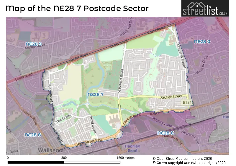
The NE28 7 Postcode shares a border with NE28 0 (WALLSEND), NE28 6 (WALLSEND, Willington Quay), NE28 8 (WALLSEND) and NE28 9 (WALLSEND).
The sector is within the post town of WALLSEND.
NE28 7 is a postcode sector within the NE28 postcode district which is within the NE Newcastle upon Tyne postcode area.
The Royal Mail delivery office for the NE28 7 postal sector is the North Tyneside Delivery Office.
The area of the NE28 7 postcode sector is 0.91 square miles which is 2.36 square kilometres or 584.34 square acres.
Waterways within the NE28 7 postcode sector include the Willington Gut.

Map of the NE28 7 Postcode Sector
Explore the NE28 7 postcode sector by using our free interactive map.
| N | E | 2 | 8 | - | 7 | X | X |
| N | E | 2 | 8 | Space | 7 | Letter | Letter |
Official List of Streets
WALLSEND (115 Streets)
Unofficial Streets or Alternative Spellings
WALLSEND
ASH GROVE BACK ELM TERRACE BATTLE HILL DRIVE CHURCH VIEW COACH ROAD CONISTON ROAD HIGH VIEW LIMEKILN COURT MYRTLE GROVE NORTH ROAD NORTH TERRACE OAK GROVE PERTH GARDENS ROSEHILL ROAD TYNEMOUTH ROAD WILLOW GROVE WINDSOR DRIVE HAWTHORN GROVE HORNBY COURT LIMEKILN ROAD ROSEHILL SIXTH FORM ENTERANCE STUDENT ENTERANCE THE BUNGALOWS WAGON WAY WESTMORELAND STREETNEWCASTLE UPON TYNE,
COAST ROADWeather Forecast for NE28 7
Press Button to Show Forecast for Wallsend
| Time Period | Icon | Description | Temperature | Rain Probability | Wind |
|---|---|---|---|---|---|
| 18:00 to 21:00 | Cloudy | 17.0°C (feels like 15.0°C) | 5.00% | W 9 mph | |
| 21:00 to 00:00 | Cloudy | 14.0°C (feels like 13.0°C) | 6.00% | W 7 mph |
Press Button to Show Forecast for Wallsend
| Time Period | Icon | Description | Temperature | Rain Probability | Wind |
|---|---|---|---|---|---|
| 00:00 to 03:00 | Cloudy | 13.0°C (feels like 12.0°C) | 6.00% | WSW 4 mph | |
| 03:00 to 06:00 | Cloudy | 12.0°C (feels like 11.0°C) | 13.00% | WSW 4 mph | |
| 06:00 to 09:00 | Cloudy | 13.0°C (feels like 12.0°C) | 6.00% | SW 4 mph | |
| 09:00 to 12:00 | Cloudy | 15.0°C (feels like 14.0°C) | 4.00% | W 7 mph | |
| 12:00 to 15:00 | Cloudy | 18.0°C (feels like 17.0°C) | 4.00% | W 7 mph | |
| 15:00 to 18:00 | Cloudy | 18.0°C (feels like 18.0°C) | 5.00% | WSW 7 mph | |
| 18:00 to 21:00 | Cloudy | 17.0°C (feels like 17.0°C) | 4.00% | WSW 4 mph | |
| 21:00 to 00:00 | Cloudy | 15.0°C (feels like 14.0°C) | 5.00% | W 4 mph |
Press Button to Show Forecast for Wallsend
| Time Period | Icon | Description | Temperature | Rain Probability | Wind |
|---|---|---|---|---|---|
| 00:00 to 03:00 | Cloudy | 13.0°C (feels like 12.0°C) | 5.00% | W 4 mph | |
| 03:00 to 06:00 | Cloudy | 12.0°C (feels like 11.0°C) | 5.00% | W 4 mph | |
| 06:00 to 09:00 | Cloudy | 12.0°C (feels like 12.0°C) | 5.00% | WSW 4 mph | |
| 09:00 to 12:00 | Cloudy | 15.0°C (feels like 14.0°C) | 5.00% | SSW 2 mph | |
| 12:00 to 15:00 | Cloudy | 17.0°C (feels like 16.0°C) | 4.00% | SSE 4 mph | |
| 15:00 to 18:00 | Cloudy | 17.0°C (feels like 16.0°C) | 3.00% | SSE 7 mph | |
| 18:00 to 21:00 | Cloudy | 16.0°C (feels like 15.0°C) | 4.00% | SSE 9 mph | |
| 21:00 to 00:00 | Partly cloudy (night) | 14.0°C (feels like 13.0°C) | 0.00% | S 4 mph |
Press Button to Show Forecast for Wallsend
| Time Period | Icon | Description | Temperature | Rain Probability | Wind |
|---|---|---|---|---|---|
| 00:00 to 03:00 | Clear night | 13.0°C (feels like 12.0°C) | 0.00% | SSW 4 mph | |
| 03:00 to 06:00 | Clear night | 12.0°C (feels like 11.0°C) | 1.00% | SSW 4 mph | |
| 06:00 to 09:00 | Partly cloudy (day) | 13.0°C (feels like 13.0°C) | 1.00% | SSW 4 mph | |
| 09:00 to 12:00 | Partly cloudy (day) | 17.0°C (feels like 16.0°C) | 1.00% | S 7 mph | |
| 12:00 to 15:00 | Partly cloudy (day) | 18.0°C (feels like 17.0°C) | 2.00% | SSE 9 mph | |
| 15:00 to 18:00 | Partly cloudy (day) | 18.0°C (feels like 16.0°C) | 1.00% | SE 11 mph | |
| 18:00 to 21:00 | Sunny day | 17.0°C (feels like 15.0°C) | 1.00% | SSE 11 mph | |
| 21:00 to 00:00 | Clear night | 14.0°C (feels like 12.0°C) | 1.00% | SSE 9 mph |
Press Button to Show Forecast for Wallsend
| Time Period | Icon | Description | Temperature | Rain Probability | Wind |
|---|---|---|---|---|---|
| 00:00 to 03:00 | Clear night | 13.0°C (feels like 12.0°C) | 1.00% | SSE 9 mph | |
| 03:00 to 06:00 | Clear night | 12.0°C (feels like 11.0°C) | 1.00% | SSE 7 mph | |
| 06:00 to 09:00 | Sunny day | 13.0°C (feels like 11.0°C) | 1.00% | SSE 9 mph | |
| 09:00 to 12:00 | Cloudy | 15.0°C (feels like 13.0°C) | 5.00% | SSE 9 mph | |
| 12:00 to 15:00 | Partly cloudy (day) | 16.0°C (feels like 14.0°C) | 4.00% | SE 11 mph | |
| 15:00 to 18:00 | Cloudy | 16.0°C (feels like 14.0°C) | 9.00% | SE 11 mph | |
| 18:00 to 21:00 | Partly cloudy (day) | 15.0°C (feels like 13.0°C) | 5.00% | SSE 11 mph | |
| 21:00 to 00:00 | Cloudy | 13.0°C (feels like 11.0°C) | 11.00% | SSE 9 mph |
Schools and Places of Education Within the NE28 7 Postcode Sector
Burnside College
Foundation school
St Peter's Road, Wallsend, Tyne and Wear, NE28 7LQ
Head: Mr Daniel Jamieson
Ofsted Rating: Good
Inspection: 2020-01-23 (1567 days ago)
Website: Visit Burnside College Website
Phone: 01912598500
Number of Pupils: 1011
Churchill Community College
Foundation school
Churchill Street, Wallsend, Tyne and Wear, NE28 7TN
Head: Mr Paul Johnson
Ofsted Rating: Good
Inspection: 2019-03-27 (1869 days ago)
Website: Visit Churchill Community College Website
Phone: 01912347200
Number of Pupils: 1046
Richardson Dees Primary School
Foundation school
High Street East, Wallsend, Tyne and Wear, NE28 7RT
Head: Mr Wayne Myers
Ofsted Rating: Good
Inspection: 2022-06-29 (679 days ago)
Website: Visit Richardson Dees Primary School Website
Phone: 01912638139
Number of Pupils: 227
House Prices in the NE28 7 Postcode Sector
| Type of Property | 2018 Average | 2018 Sales | 2017 Average | 2017 Sales | 2016 Average | 2016 Sales | 2015 Average | 2015 Sales |
|---|---|---|---|---|---|---|---|---|
| Detached | £272,214 | 7 | £220,767 | 9 | £216,133 | 15 | £228,176 | 41 |
| Semi-Detached | £131,152 | 28 | £121,922 | 37 | £139,460 | 29 | £117,202 | 27 |
| Terraced | £110,478 | 34 | £111,141 | 40 | £116,052 | 25 | £94,320 | 45 |
| Flats | £65,438 | 46 | £72,942 | 30 | £71,324 | 54 | £64,036 | 48 |
Important Postcodes NE28 7 in the Postcode Sector
NE28 7LQ is the postcode for BLOCK 1, Burnside Business and Enterprise College, St. Peters Road, Burnside Business and Enterprise College, St. Peters Road, BLOCK 3, Burnside Business and Enterprise College, St. Peters Road, BLOCK 1, Burnside Community High School, St. Peters Road, BLOCK 3, Burnside Community High School, St. Peters Road, MAIN BUILDING, Burnside Community High School, St. Peters Road, MAIN BUILDING, Burnside Business and Enterprise College, St. Peters Road, BLOCK 2, Burnside Business and Enterprise College, St. Peters Road, and BLOCK 2, Burnside Community High School, St. Peters Road
NE28 7NB is the postcode for North Tyneside Council, Wallsend Library, Ferndale Avenue
NE28 7PB is the postcode for Sir G B Hunter Memorial Hospital, The Green
NE28 7PD is the postcode for WALLSEND HEALTH CENTRE, THE GREEN, WALLSEND, and Wallsend Health Centre, The Green
NE28 7RR is the postcode for North Tyneside Council, Town Hall
NE28 7RT is the postcode for Richardson Dees Primary School, High Street East, and Richardson Dees Community Primary School, High Street East
NE28 7RW is the postcode for Northumbria Police, Wallsend Police Station
NE28 7TN is the postcode for Churchill Community College, Churchill Street
| The NE28 7 Sector is within these Local Authorities |
|
|---|---|
| The NE28 7 Sector is within these Counties |
|
| The NE28 7 Sector is within these Water Company Areas |
|