The NE3 5 postcode sector is within the county of Tyne & Wear.
Did you know? According to the 2021 Census, the NE3 5 postcode sector is home to a bustling 8,257 residents!
Given that each sector allows for 400 unique postcode combinations. Letters C, I, K, M, O and V are not allowed in the last two letters of a postcode. With 169 postcodes already in use, this leaves 231 units available.
The largest settlement in the NE3 5 postal code is NEWCASTLE UPON TYNE followed by Gosforth, and High Gosforth Park.
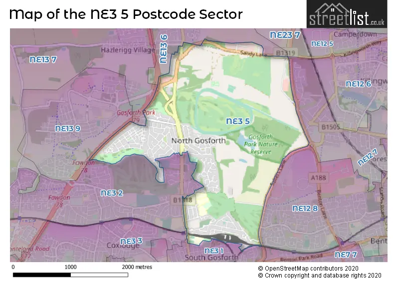
The NE3 5 Postcode shares a border with NE3 1 (NEWCASTLE UPON TYNE, Gosforth, South Gosforth), NE3 2 (NEWCASTLE UPON TYNE, Gosforth, Fawdon), NE3 3 (NEWCASTLE UPON TYNE, Gosforth), NE12 7 (NEWCASTLE UPON TYNE, Killingworth, Forest Hall), NE12 8 (NEWCASTLE UPON TYNE, Longbenton, Benton), NE13 6 (Wideopen, Seaton Burn, North Gosforth), NE13 7 (Hazlerigg, Dinnington, Brunswick Village), NE13 9 (NEWCASTLE UPON TYNE) and NE23 7 (Dudley, Seghill, Annitsford).
The sector is within the post town of NEWCASTLE UPON TYNE.
NE3 5 is a postcode sector within the NE3 postcode district which is within the NE Newcastle upon Tyne postcode area.
The Royal Mail delivery office for the NE3 5 postal sector is the Gosforth Delivery Office.
The area of the NE3 5 postcode sector is 2.79 square miles which is 7.23 square kilometres or 1,786.40 square acres.
The NE3 5 postcode sector is crossed by the A1 Major A road.
Waterways within the NE3 5 postcode sector include the Ouseburn.

Map of the NE3 5 Postcode Sector
Explore the NE3 5 postcode sector by using our free interactive map.
| N | E | 3 | - | 5 | X | X |
| N | E | 3 | Space | 5 | Letter | Letter |
Official List of Streets
NEWCASTLE UPON TYNE (98 Streets)
Gosforth (9 Streets)
Brunton Park (2 Streets)
North Gosforth (2 Streets)
High Gosforth Park (1 Streets)
Melton Park (1 Streets)
Unofficial Streets or Alternative Spellings
Dudley
GREAT LIME ROAD BRANCKENPETH MEWS CONNINGSBY CLOSE EASDALE AVENUE GILWELL WAY KNIGHTSBRIDGE WHITE HOUSE FARM ROUNDABOUT WHITEBRIDGE PARKNEWCASTLE UPON TYNE
CHRISTON ROAD POLWARTH CRESCENT SOUTH RIDGE WHITEBRIDGE COURTNorth Gosforth
ASCOT DRIVE SANDY LANEGosforth
HIGH STREET PARK AVENUEBrunton Bridge
BRUNTON LANESchools and Places of Education Within the NE3 5 Postcode Sector
Gosforth East Middle School
Foundation school
Harewood Road, Newcastle-upon-Tyne, Tyne and Wear, NE3 5JT
Head: Mr Tim Stout
Ofsted Rating: Good
Inspection: 2023-07-04 (324 days ago)
Website: Visit Gosforth East Middle School Website
Phone: 01912855445
Number of Pupils: 512
Gosforth Park First School
Foundation school
Broadway East, Newcastle-upon-Tyne, Tyne and Wear, NE3 5JQ
Head: Mrs Leanne Lamb
Ofsted Rating: Good
Inspection: 2020-02-05 (1569 days ago)
Website: Visit Gosforth Park First School Website
Phone: 01912852559
Number of Pupils: 259
St Oswald's Catholic Primary School, Gosforth
Academy converter
Hartford Road, Newcastle-upon-Tyne, Tyne and Wear, NE3 5LE
Head: Mr Paul Marley
Ofsted Rating: Good
Inspection: 2022-12-14 (526 days ago)
Website: Visit St Oswald's Catholic Primary School, Gosforth Website
Phone: 01912852437
Number of Pupils: 210
House Prices in the NE3 5 Postcode Sector
| Type of Property | 2018 Average | 2018 Sales | 2017 Average | 2017 Sales | 2016 Average | 2016 Sales | 2015 Average | 2015 Sales |
|---|---|---|---|---|---|---|---|---|
| Detached | £415,609 | 27 | £370,192 | 39 | £396,813 | 28 | £370,920 | 25 |
| Semi-Detached | £296,293 | 46 | £268,665 | 60 | £232,683 | 51 | £243,802 | 65 |
| Terraced | £257,193 | 48 | £257,120 | 39 | £249,609 | 39 | £265,994 | 41 |
| Flats | £137,750 | 4 | £145,960 | 6 | £142,823 | 7 | £128,185 | 9 |
Important Postcodes NE3 5 in the Postcode Sector
NE3 5HB is the postcode for Vehicle & Operator Services Agency, Testing Station, Sandy Lane, Driver and Vehicle Standards Agency, Sandy Lane, SVA & VIC TESTING BUILDING, Vehicle & Operator Services Agency, Testing Station, Sandy Lane, and Driver and Vehicles Standards Agency, Sandy Lane, Gosforth
NE3 5JQ is the postcode for Broadway East First School, Broadway East, and Gosforth Park First School, Broadway East
NE3 5JT is the postcode for Gosforth East Middle School, Harewood Road
NE3 5LE is the postcode for St. Oswalds RC Primary School, Hartford Road
| The NE3 5 Sector is within these Local Authorities |
|
|---|---|
| The NE3 5 Sector is within these Counties |
|
| The NE3 5 Sector is within these Water Company Areas |
|