The NE47 8 postcode sector lies where the three counties of Durham, Cumbria, and Northumberland meet.
Did you know? According to the 2021 Census, the NE47 8 postcode sector is home to a bustling 466 residents!
Given that each sector allows for 400 unique postcode combinations. Letters C, I, K, M, O and V are not allowed in the last two letters of a postcode. With 65 postcodes already in use, this leaves 335 units available.
The largest settlement in the NE47 8 postal code is Whitfield followed by Carrshield, and Ninebanks.
The NE47 8 Postcode shares a border with NE47 9 (Allendale, Catton, Allenheads), NE49 0 (HALTWHISTLE, Coanwood, Melkridge), DL13 1 (Westgate, St. Johns Chapel, Wearhead), NE47 5 (Newbrough, Fourstones, Langley-on-Tyne), NE47 7 (Bardon Mill, Henshaw, Redburn), CA8 7 (Gilsland, Greenhead, Slaggyford) and CA9 3 (ALSTON, Garrigill, Nenthead).
The sector is within the post town of HEXHAM.
NE47 8 is a postcode sector within the NE47 postcode district which is within the NE Newcastle upon Tyne postcode area.
The Royal Mail delivery office for the NE47 8 postal sector is the Hexham Delivery Office.
The area of the NE47 8 postcode sector is 36.56 square miles which is 94.70 square kilometres or 23,399.68 square acres.
Waterways within the NE47 8 postcode sector include the Swinhope Burn, East Allen, West Allen, Whitewalls Burn, Carr's Burn, Blaeberry Burn, Church Burn, Kingswood Burn, Redscar Burn, Dewsgreen Burn, Oldhouse Sike.

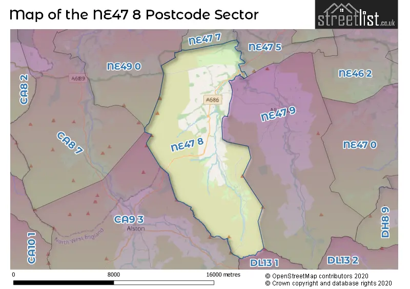
Map of the NE47 8 Postcode Sector
Explore the NE47 8 postcode sector by using our free interactive map.
| N | E | 4 | 7 | - | 8 | X | X |
| N | E | 4 | 7 | Space | 8 | Letter | Letter |
Official List of Streets
Carrshield (2 Streets)
Whitfield (4 Streets)
Unofficial Streets or Alternative Spellings
Schools and Places of Education Within the NE47 8 Postcode Sector
Whitfield CofE Primary School
Academy sponsor led
Whitfield, Hexham, Northumberland, NE47 8JH
Head: Mr Rob Blake
Ofsted Rating: Good
Inspection: 2021-11-10 (925 days ago)
Website: Visit Whitfield CofE Primary School Website
Phone: 01434345267
Number of Pupils: 23
House Prices in the NE47 8 Postcode Sector
| Type of Property | 2018 Average | 2018 Sales | 2017 Average | 2017 Sales | 2016 Average | 2016 Sales | 2015 Average | 2015 Sales |
|---|---|---|---|---|---|---|---|---|
| Detached | £0 | 0 | £410,000 | 1 | £243,333 | 3 | £191,667 | 3 |
| Semi-Detached | £109,750 | 2 | £0 | 0 | £0 | 0 | £218,750 | 2 |
| Terraced | £0 | 0 | £124,950 | 1 | £0 | 0 | £0 | 0 |
| Flats | £0 | 0 | £0 | 0 | £0 | 0 | £150,000 | 1 |
| The NE47 8 Sector is within these Local Authorities |
|
|---|---|
| The NE47 8 Sector is within these Counties |
|
| The NE47 8 Sector is within these Water Company Areas |
|