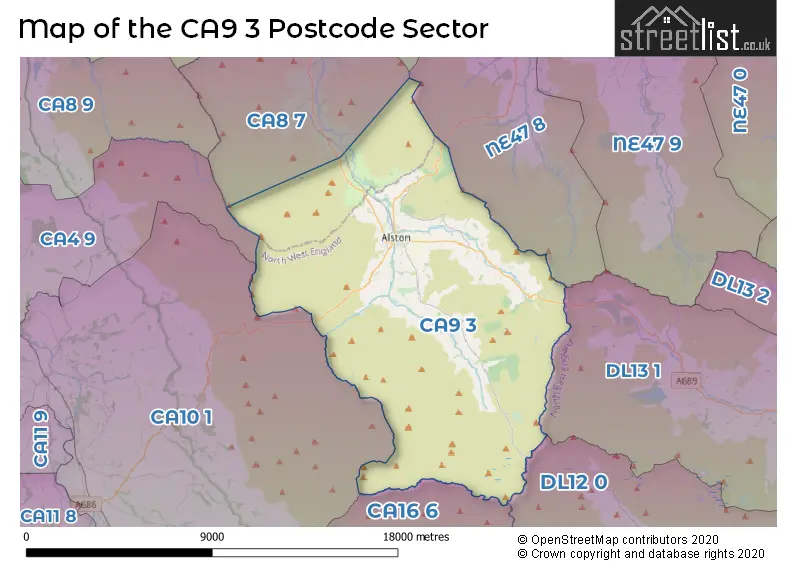
The CA9 3 postcode sector lies where the three counties of Cumbria, Durham, and Northumberland meet.
Did you know? According to the 2021 Census, the CA9 3 postcode sector is home to a bustling 2,081 residents!
Given that each sector allows for 400 unique postcode combinations. Letters C, I, K, M, O and V are not allowed in the last two letters of a postcode. With 177 postcodes already in use, this leaves 223 units available.
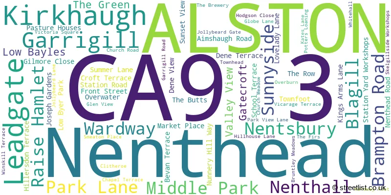
The largest settlement in the CA9 3 postal code is ALSTON followed by Garrigill, and Nenthead.
The CA9 3 Postcode shares a border with NE47 8 (Whitfield, Carrshield, Ninebanks), CA4 9 (Armathwaite, Ainstable, Croglin), CA16 6 (APPLEBY-IN-WESTMORLAND, Bolton, Long Marton), DL12 0 (Middleton-in-Teesdale, Eggleston, Mickleton), DL13 1 (Westgate, St. Johns Chapel, Wearhead), CA8 7 (Gilsland, Greenhead, Slaggyford) and CA10 1 (Lazonby, Kirkby Thore, Langwathby).
The sector is within the post town of ALSTON.
CA9 3 is a postcode sector within the CA9 postcode district which is within the CA Carlisle postcode area.
The Royal Mail delivery office for the CA9 3 postal sector is the Alston Scale Payment Delivery Office.
The area of the CA9 3 postcode sector is 69.38 square miles which is 179.70 square kilometres or 44,403.61 square acres.
Waterways within the CA9 3 postcode sector include the River South Tyne, Gilderdale Burn, Woldgill Burn, Ayle Burn, Thornhope Burn, Nent, Rawgill Burn, Snittergill Burn, Black Burn, River Tees, Swath Beck, Dorth Gill ?, Cross Gill, Duffergill Burn, Cash Burn, Rotherhope Cleugh, Little Dry Burn, Dry Burn, Long Grain.

Map of the CA9 3 Postcode Sector
Explore the CA9 3 postcode sector by using our free interactive map.
| C | A | 9 | - | 3 | X | X |
| C | A | 9 | Space | 3 | Letter | Letter |
Official List of Streets
Leadgate (1 Streets)
Nenthead (17 Streets)
ALSTON (38 Streets)
Garrigill (4 Streets)
Unofficial Streets or Alternative Spellings
Weather Forecast for CA9 3
Press Button to Show Forecast for Alston Youth Hostel
| Time Period | Icon | Description | Temperature | Rain Probability | Wind |
|---|---|---|---|---|---|
| 06:00 to 09:00 | Overcast | 1.0°C (feels like 0.0°C) | 7.00% | E 2 mph | |
| 09:00 to 12:00 | Overcast | 4.0°C (feels like 2.0°C) | 12.00% | NE 4 mph | |
| 12:00 to 15:00 | Light rain | 6.0°C (feels like 4.0°C) | 40.00% | ENE 7 mph | |
| 15:00 to 18:00 | Overcast | 6.0°C (feels like 4.0°C) | 15.00% | E 7 mph | |
| 18:00 to 21:00 | Cloudy | 5.0°C (feels like 3.0°C) | 12.00% | E 4 mph | |
| 21:00 to 00:00 | Partly cloudy (night) | 2.0°C (feels like 0.0°C) | 2.00% | ESE 4 mph |
Press Button to Show Forecast for Alston Youth Hostel
| Time Period | Icon | Description | Temperature | Rain Probability | Wind |
|---|---|---|---|---|---|
| 00:00 to 03:00 | Partly cloudy (night) | 0.0°C (feels like -2.0°C) | 2.00% | ESE 2 mph | |
| 03:00 to 06:00 | Partly cloudy (night) | -1.0°C (feels like -2.0°C) | 4.00% | ESE 2 mph | |
| 06:00 to 09:00 | Partly cloudy (day) | 2.0°C (feels like 1.0°C) | 5.00% | ESE 2 mph | |
| 09:00 to 12:00 | Cloudy | 6.0°C (feels like 3.0°C) | 11.00% | ESE 7 mph | |
| 12:00 to 15:00 | Overcast | 7.0°C (feels like 5.0°C) | 15.00% | E 7 mph | |
| 15:00 to 18:00 | Overcast | 8.0°C (feels like 5.0°C) | 15.00% | E 9 mph | |
| 18:00 to 21:00 | Cloudy | 6.0°C (feels like 4.0°C) | 11.00% | E 9 mph | |
| 21:00 to 00:00 | Cloudy | 3.0°C (feels like 1.0°C) | 13.00% | ENE 4 mph |
Press Button to Show Forecast for Alston Youth Hostel
| Time Period | Icon | Description | Temperature | Rain Probability | Wind |
|---|---|---|---|---|---|
| 00:00 to 03:00 | Cloudy | 2.0°C (feels like 0.0°C) | 15.00% | ENE 4 mph | |
| 03:00 to 06:00 | Cloudy | 3.0°C (feels like 1.0°C) | 16.00% | NE 4 mph | |
| 06:00 to 09:00 | Cloudy | 4.0°C (feels like 2.0°C) | 16.00% | NE 7 mph | |
| 09:00 to 12:00 | Light rain | 6.0°C (feels like 4.0°C) | 46.00% | NE 9 mph | |
| 12:00 to 15:00 | Overcast | 8.0°C (feels like 5.0°C) | 21.00% | NE 9 mph | |
| 15:00 to 18:00 | Cloudy | 9.0°C (feels like 6.0°C) | 20.00% | NNE 9 mph | |
| 18:00 to 21:00 | Heavy rain shower (day) | 8.0°C (feels like 6.0°C) | 55.00% | SW 7 mph | |
| 21:00 to 00:00 | Cloudy | 5.0°C (feels like 3.0°C) | 14.00% | SSW 7 mph |
Schools and Places of Education Within the CA9 3 Postcode Sector
Alston Primary School
Community school
Church Road, Alston, , CA9 3QU
Head: Mr Rob Dawson
Ofsted Rating: Good
Inspection: 2019-06-27 (1765 days ago)
Website: Visit Alston Primary School Website
Phone: 01434381236
Number of Pupils: 100
Nenthead Primary School
Community school
Nenthead, Alston, Cumbria, CA9 3LS
Head: Mr Rob Dawson
Ofsted Rating: Good
Inspection: 2018-10-03 (2032 days ago)
Website: Visit Nenthead Primary School Website
Phone: 01434381400
Number of Pupils: 20
Samuel King's School
Foundation school
Church Road, Alston, Cumbria, CA9 3QU
Head: Mr Rob Dawson
Ofsted Rating: Good
Inspection: 2022-07-06 (660 days ago)
Website: Visit Samuel King's School Website
Phone: 01434381236
Number of Pupils: 81
House Prices in the CA9 3 Postcode Sector
| Type of Property | 2018 Average | 2018 Sales | 2017 Average | 2017 Sales | 2016 Average | 2016 Sales | 2015 Average | 2015 Sales |
|---|---|---|---|---|---|---|---|---|
| Detached | £257,079 | 12 | £239,172 | 18 | £248,400 | 8 | £205,194 | 18 |
| Semi-Detached | £185,500 | 11 | £111,790 | 5 | £149,883 | 9 | £107,643 | 7 |
| Terraced | £130,611 | 9 | £130,707 | 14 | £147,125 | 12 | £120,245 | 10 |
| Flats | £85,188 | 4 | £65,500 | 2 | £0 | 0 | £35,500 | 1 |
Important Postcodes CA9 3 in the Postcode Sector
CA9 3QS is the postcode for Grisedale Croft, Church Road
CA9 3QU is the postcode for Samuel Kings School, Church Road
CA9 3QX is the postcode for Ruth Lancaster James Cottage Hospital, Church Road
| The CA9 3 Sector is within these Local Authorities |
|
|---|---|
| The CA9 3 Sector is within these Counties |
|
| The CA9 3 Sector is within these Water Company Areas |
|