The CA9 postcode district is a postal district located in the CA Carlisle postcode area with a population of 2,081 residents according to the 2021 England and Wales Census.
The area of the CA9 postcode district is 69.38 square miles which is 179.70 square kilometres or 44,403.61 acres.
Currently, the CA9 district has about 177 postcode units spread across 1 geographic postcode sectors.
Given that each sector allows for 400 unique postcode combinations, the district has a capacity of 400 postcodes. With 177 postcodes already in use, this leaves 223 units available.
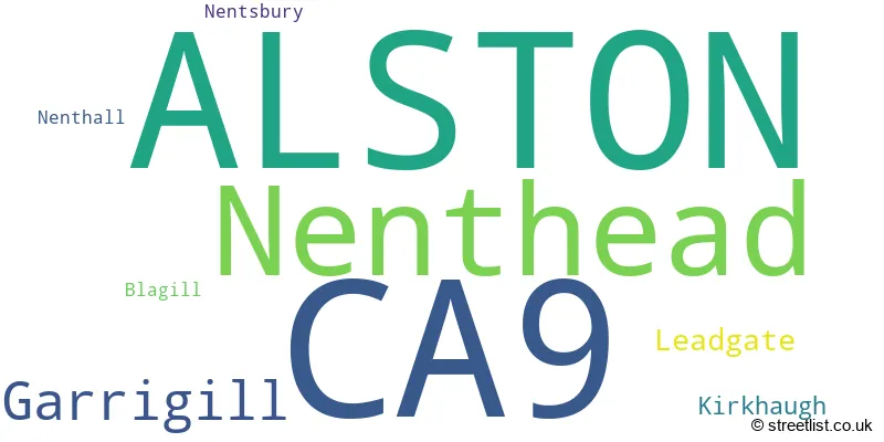
The largest settlement in the CA9 postal code is ALSTON followed by Garrigill, and Nenthead.
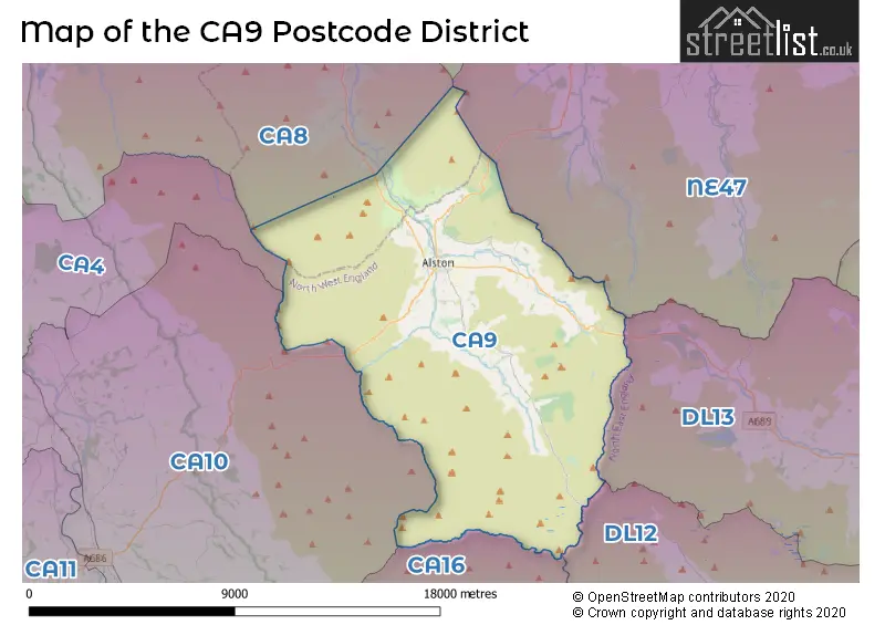
The CA9 Postcode shares a border with CA10 (Shap, Whinfell, Lazonby), CA16 (APPLEBY-IN-WESTMORLAND, Bolton, Long Marton), CA8 (BRAMPTON, Heads Nook, Gilsland), NE47 (Haydon Bridge, Allendale, Bardon Mill), DL12 (BARNARD CASTLE, Middleton-in-Teesdale, Eggleston) and DL13 (Tow Law, Wolsingham, Stanhope).
The primary settlement in the CA9 postcode district is Alston, located in the county of Cumbria. Other significant settlements in the district include Blagill, Garrigill, Kirkhaugh, Leadgate, Nenthall, Nenthead, and Nentsbury. The most significant post town in the district is also Alston, in Cumbria.
For the district CA9, we have data on 1 postcode sectors. Here's a breakdown: The sector CA9 3, covers Alston and Nenthead and Garrigill in Cumbria.
CA9 Postcode Sectors

Map of the CA9 Postcode District
Explore the CA9 postcode district by using our free interactive map.
When it comes to local government, postal geography often disregards political borders. However, for a breakdown in the CA9 District: the district mostly encompasses the Westmorland and Furness (174 postcodes), and finally, the Northumberland area (4 postcodes).
Where is the CA9 Postcode District?
The postcode district CA9 is located in Alston, a town in Cumbria. Alston is situated near several nearby towns: Haltwhistle to the north (14.5 miles away), Appleby-in-Westmorland to the south (15.6 miles away), Penrith to the southwest (16.1 miles away), Brampton to the northwest (16.6 miles away), Hexham to the northeast (17.7 miles away), and Carlisle to the west (22.3 miles away). Additionally, Alston is approximately 245.8 miles away from the center of London.
The district is within the post town of ALSTON.
The sector has postcodes within the nation of England.
The CA9 Postcode District is covers the following regions.
- East Cumbria - Cumbria - North West (England)
- Northumberland - Northumberland and Tyne and Wear - North East (England)
Weather Forecast for CA9
Press Button to Show Forecast for Alston Youth Hostel
| Time Period | Icon | Description | Temperature | Rain Probability | Wind |
|---|---|---|---|---|---|
| 15:00 to 18:00 | Sunny day | 19.0°C (feels like 17.0°C) | 0.00% | SW 7 mph | |
| 18:00 to 21:00 | Sunny day | 17.0°C (feels like 17.0°C) | 0.00% | SSW 4 mph | |
| 21:00 to 00:00 | Clear night | 12.0°C (feels like 11.0°C) | 0.00% | SSE 2 mph |
Press Button to Show Forecast for Alston Youth Hostel
| Time Period | Icon | Description | Temperature | Rain Probability | Wind |
|---|---|---|---|---|---|
| 00:00 to 03:00 | Clear night | 11.0°C (feels like 11.0°C) | 1.00% | SSE 4 mph | |
| 03:00 to 06:00 | Clear night | 11.0°C (feels like 11.0°C) | 1.00% | SE 4 mph | |
| 06:00 to 09:00 | Sunny day | 14.0°C (feels like 14.0°C) | 0.00% | SE 4 mph | |
| 09:00 to 12:00 | Partly cloudy (day) | 19.0°C (feels like 18.0°C) | 1.00% | S 7 mph | |
| 12:00 to 15:00 | Cloudy | 20.0°C (feels like 18.0°C) | 13.00% | S 9 mph | |
| 15:00 to 18:00 | Cloudy | 19.0°C (feels like 18.0°C) | 13.00% | S 9 mph | |
| 18:00 to 21:00 | Cloudy | 18.0°C (feels like 17.0°C) | 7.00% | SSE 7 mph | |
| 21:00 to 00:00 | Cloudy | 14.0°C (feels like 12.0°C) | 3.00% | SE 7 mph |
Press Button to Show Forecast for Alston Youth Hostel
| Time Period | Icon | Description | Temperature | Rain Probability | Wind |
|---|---|---|---|---|---|
| 00:00 to 03:00 | Cloudy | 12.0°C (feels like 11.0°C) | 3.00% | SE 7 mph | |
| 03:00 to 06:00 | Cloudy | 11.0°C (feels like 10.0°C) | 3.00% | SE 7 mph | |
| 06:00 to 09:00 | Cloudy | 12.0°C (feels like 11.0°C) | 3.00% | SE 7 mph | |
| 09:00 to 12:00 | Cloudy | 16.0°C (feels like 14.0°C) | 5.00% | SSE 9 mph | |
| 12:00 to 15:00 | Cloudy | 18.0°C (feels like 15.0°C) | 7.00% | SSE 11 mph | |
| 15:00 to 18:00 | Light rain shower (day) | 17.0°C (feels like 15.0°C) | 31.00% | SSE 11 mph | |
| 18:00 to 21:00 | Cloudy | 16.0°C (feels like 15.0°C) | 13.00% | SE 9 mph | |
| 21:00 to 00:00 | Cloudy | 13.0°C (feels like 12.0°C) | 18.00% | SE 7 mph |
Press Button to Show Forecast for Alston Youth Hostel
| Time Period | Icon | Description | Temperature | Rain Probability | Wind |
|---|---|---|---|---|---|
| 00:00 to 03:00 | Cloudy | 12.0°C (feels like 11.0°C) | 14.00% | SE 7 mph | |
| 03:00 to 06:00 | Cloudy | 11.0°C (feels like 10.0°C) | 16.00% | SE 4 mph | |
| 06:00 to 09:00 | Cloudy | 12.0°C (feels like 11.0°C) | 13.00% | SE 7 mph | |
| 09:00 to 12:00 | Light rain shower (day) | 14.0°C (feels like 13.0°C) | 34.00% | SSE 7 mph | |
| 12:00 to 15:00 | Light rain shower (day) | 15.0°C (feels like 14.0°C) | 42.00% | S 9 mph | |
| 15:00 to 18:00 | Light rain shower (day) | 15.0°C (feels like 14.0°C) | 40.00% | S 9 mph | |
| 18:00 to 21:00 | Light rain shower (day) | 14.0°C (feels like 12.0°C) | 45.00% | SSE 9 mph | |
| 21:00 to 00:00 | Light rain | 12.0°C (feels like 11.0°C) | 52.00% | SE 7 mph |
Press Button to Show Forecast for Alston Youth Hostel
| Time Period | Icon | Description | Temperature | Rain Probability | Wind |
|---|---|---|---|---|---|
| 00:00 to 03:00 | Light rain | 11.0°C (feels like 10.0°C) | 49.00% | SE 7 mph | |
| 03:00 to 06:00 | Cloudy | 10.0°C (feels like 9.0°C) | 17.00% | SE 7 mph | |
| 06:00 to 09:00 | Cloudy | 10.0°C (feels like 9.0°C) | 17.00% | SE 7 mph | |
| 09:00 to 12:00 | Light rain shower (day) | 12.0°C (feels like 10.0°C) | 33.00% | SE 9 mph | |
| 12:00 to 15:00 | Light rain shower (day) | 13.0°C (feels like 11.0°C) | 38.00% | SSE 11 mph | |
| 15:00 to 18:00 | Light rain shower (day) | 14.0°C (feels like 12.0°C) | 39.00% | SSE 11 mph | |
| 18:00 to 21:00 | Light rain shower (day) | 12.0°C (feels like 10.0°C) | 35.00% | SSE 11 mph | |
| 21:00 to 00:00 | Cloudy | 10.0°C (feels like 8.0°C) | 8.00% | SE 9 mph |
Postcode Sectors within the CA9 District
| Postcode Sector | Delivery Office |
|---|---|
| CA9 3 | Alston Scale Payment Delivery Office |
| C | A | 9 | - | X | X | X |
| C | A | 9 | Space | Numeric | Letter | Letter |
Current Monthly Rental Prices
| # Bedrooms | Min Price | Max Price | Avg Price |
|---|
Current House Prices
| # Bedrooms | Min Price | Max Price | Avg Price |
|---|---|---|---|
| £250,000 | £365,000 | £322,500 | |
| 2 | £285,000 | £285,000 | £285,000 |
| 3 | £189,000 | £350,000 | £289,400 |
| 4 | £195,000 | £395,000 | £302,500 |
| 5 | £325,000 | £800,000 | £523,750 |
| 6 | £299,995 | £525,000 | £412,498 |
Estate Agents who Operate in the CA9 District
| Logo | Name | Brand Name | Address | Contact Number | Total Properties |
|---|---|---|---|---|---|
 | Hexham | Red Hot Property | 13 Battle Hill, Hexham, NE46 1BA | 01435 511539 | 11 |
 | Penrith | David Britton Estates | 15, Old London Road Penrith Cumbria CA11 8JJ | 01768 800886 | 7 |
 | Darlington | Vickers & Barrass | Darlington Farmers Auction Mart Humbleton Park, West Auckland Road, Darlington, DL2 2YH | 01325 808664 | 4 |
 | Corbridge | Finest Properties | Crossways, Market Place, Corbridge NE45 5AW | 01434 409033 | 3 |
 | Carlisle | H&H Land & Estates | 2/2A Lowther Street Carlisle CA3 8DA | 01228 276977 | 2 |
Yearly House Price Averages for the CA9 Postcode District
| Type of Property | 2018 Average | 2018 Sales | 2017 Average | 2017 Sales | 2016 Average | 2016 Sales | 2015 Average | 2015 Sales |
|---|---|---|---|---|---|---|---|---|
| Detached | £257,079 | 12 | £239,172 | 18 | £248,400 | 8 | £205,194 | 18 |
| Semi-Detached | £185,500 | 11 | £111,790 | 5 | £149,883 | 9 | £107,643 | 7 |
| Terraced | £130,611 | 9 | £130,707 | 14 | £147,125 | 12 | £120,245 | 10 |
| Flats | £85,188 | 4 | £65,500 | 2 | £0 | 0 | £35,500 | 1 |