The NE66 2 postcode sector is within the county of Northumberland.
Did you know? According to the 2021 Census, the NE66 2 postcode sector is home to a bustling 4,370 residents!
Given that each sector allows for 400 unique postcode combinations. Letters C, I, K, M, O and V are not allowed in the last two letters of a postcode. With 265 postcodes already in use, this leaves 135 units available.
The largest settlement in the NE66 2 postal code is ALNWICK followed by Shilbottle, and Alnmouth.
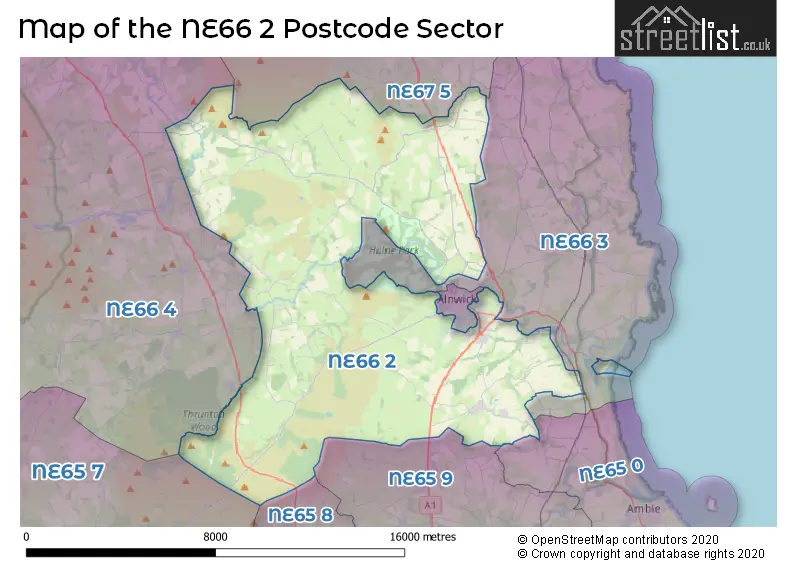
The NE66 2 Postcode shares a border with NE65 7 (Rothbury, Thropton, Harbottle), NE65 8 (Longframlington, Longhorsley, Wingates), NE65 9 (Felton, Hadston, Swarland), NE66 1 (ALNWICK, Swordy Park), NE66 3 (Longhoughton, Lesbury, Embleton), NE66 4 (Whittingham, Powburn, Glanton), NE65 0 (Amble, Warkworth, High Hauxley) and NE67 5 (Beadnell, CHATHILL, Ellingham).
The sector is within the post town of ALNWICK.
NE66 2 is a postcode sector within the NE6 postcode district which is within the NE Newcastle upon Tyne postcode area.
The Royal Mail delivery office for the NE66 2 postal sector is the Heaton Delivery Office.
The area of the NE66 2 postcode sector is 67.56 square miles which is 174.97 square kilometres or 43,236.43 square acres.
The NE66 2 postcode sector is crossed by the A1 Major A road.
Waterways within the NE66 2 postcode sector include the Aln, Shipley Burn, Grange Burn, Tyelaw Burn, Eglingham Burn, Tillington Burn, Eglingham, Harehope Burn, River Breamish, Red Burn, Black Burn.

Map of the NE66 2 Postcode Sector
Explore the NE66 2 postcode sector by using our free interactive map.
| N | E | 6 | 6 | - | 2 | X | X |
| N | E | 6 | 6 | Space | 2 | Letter | Letter |
Official List of Streets
ALNWICK (36 Streets)
Alnmouth (20 Streets)
Shilbottle (38 Streets)
Bilton (1 Streets)
Lionheart Enterprise Park (7 Streets)
South Charlton (2 Streets)
Eglingham (3 Streets)
Edlingham (1 Streets)
Peters Mill (4 Streets)
Bolton (1 Streets)
Lesbury (1 Streets)
Unofficial Streets or Alternative Spellings
Alnmouth
FRIARY GARDENS ABBERWICK FORD ABBEYFIELD ALNWICK ALNWICK ABBEY DRIVE ARMORER COURT ARMOURERS COURT ASH CLOSE BACK BRIDGE STREET BACK DUKE STREET BILTON BANKS & SHILBOTTLE BILTON BARNS & HIGH BUSTON BLACK DEAN DRIVE BRIDGE 6 BUTCHERS CLOSE CARPENTERS CRESCENT CAT CRAIG DRIVE CAWLEDGE BRIDGE CAWLEDGE EAST PARK & GREENRIG CAWLEDGE VIADUCT CLOUDY CRAGS DRIVE COCK PIT DRIVE CUTHBERT HEUGH DRIVE DEER PARK DRIVE DENWICK LANE DILCHBURN ROAD DINGLE DRIVE DUCHESSS DRIVE EAST BOLTON FARM COTTAGES EAST BOLTON HALL CARRIAGE TRACK EAST BOLTON TO TITLINGTON EDENHILL BRIDGE EDLINGHAM VIADUCT FARM DRIVE FARM ROAD FARNE END FILBERT HAUGH BRIDGE FISHER LANE FRIARS WELL DRIVE GARMINTEDGE BANK GREEN LANE GREENSFIELD COURT HIGH PALMSTROTHER DRIVE HILLCREST ROAD HINDING LANE HOPE HOUSE LANE HOTSPUR COURT HOTTERELL DRIVE JENNYS LANTERN TRACK JOINERS GARDENS LADYS WELL DRIVE LEMMINGTON BANK LINNET COURT MERCERS WAY MOOR BURN DRIVE PEASES LANE RUGLEY BRIDGE SHELLRIGG BRIDGE SHIPLEY BRIDGE SHIPLEY BURN DRIVE SMILEY LANE SNIPE HOUSE SOUTH EAST FARM BRIDLEWAY SPRINGFIELD WAY SPY LAW & GREENRIGG THE CROFTS THE PETH TOWNFOOT TOWNFOOT & SHILBOTTLE TURNING CIRCLE VINTNERS COURT WAGON WAY ROAD WHITE HOUSE DRIVE WHITESMITHS WAY WOOD HOUSE WOODEN FARMALNWICK
BONDGATE WITHOUT BRIDGE STREET CANONGATE CHAPEL LANDS COLUMN MEWS DUKE STREET MEADOW RIGGS PRUDHOE STREETWeather Forecast for NE66 2
Press Button to Show Forecast for Powburn
| Time Period | Icon | Description | Temperature | Rain Probability | Wind |
|---|---|---|---|---|---|
| 21:00 to 00:00 | Clear night | 6.0°C (feels like 3.0°C) | 1.00% | SW 9 mph |
Press Button to Show Forecast for Powburn
| Time Period | Icon | Description | Temperature | Rain Probability | Wind |
|---|---|---|---|---|---|
| 00:00 to 03:00 | Clear night | 4.0°C (feels like 1.0°C) | 4.00% | SSW 9 mph | |
| 03:00 to 06:00 | Light rain shower (night) | 5.0°C (feels like 2.0°C) | 37.00% | S 9 mph | |
| 06:00 to 09:00 | Light rain shower (day) | 7.0°C (feels like 4.0°C) | 37.00% | S 9 mph | |
| 09:00 to 12:00 | Light rain | 9.0°C (feels like 7.0°C) | 49.00% | S 11 mph | |
| 12:00 to 15:00 | Light rain | 11.0°C (feels like 8.0°C) | 52.00% | S 13 mph | |
| 15:00 to 18:00 | Light rain | 11.0°C (feels like 9.0°C) | 53.00% | S 16 mph | |
| 18:00 to 21:00 | Cloudy | 11.0°C (feels like 8.0°C) | 15.00% | S 16 mph | |
| 21:00 to 00:00 | Cloudy | 10.0°C (feels like 7.0°C) | 13.00% | S 11 mph |
Press Button to Show Forecast for Powburn
| Time Period | Icon | Description | Temperature | Rain Probability | Wind |
|---|---|---|---|---|---|
| 00:00 to 03:00 | Cloudy | 9.0°C (feels like 7.0°C) | 8.00% | S 11 mph | |
| 03:00 to 06:00 | Partly cloudy (night) | 8.0°C (feels like 6.0°C) | 2.00% | SSE 9 mph | |
| 06:00 to 09:00 | Cloudy | 8.0°C (feels like 6.0°C) | 5.00% | SSE 11 mph | |
| 09:00 to 12:00 | Partly cloudy (day) | 11.0°C (feels like 9.0°C) | 1.00% | SSE 13 mph | |
| 12:00 to 15:00 | Partly cloudy (day) | 14.0°C (feels like 11.0°C) | 2.00% | SE 16 mph | |
| 15:00 to 18:00 | Sunny day | 14.0°C (feels like 11.0°C) | 2.00% | SE 16 mph | |
| 18:00 to 21:00 | Partly cloudy (day) | 11.0°C (feels like 9.0°C) | 3.00% | SE 11 mph | |
| 21:00 to 00:00 | Cloudy | 9.0°C (feels like 7.0°C) | 8.00% | SE 9 mph |
Press Button to Show Forecast for Powburn
| Time Period | Icon | Description | Temperature | Rain Probability | Wind |
|---|---|---|---|---|---|
| 00:00 to 03:00 | Mist | 8.0°C (feels like 7.0°C) | 17.00% | SE 4 mph | |
| 03:00 to 06:00 | Fog | 8.0°C (feels like 7.0°C) | 20.00% | SE 4 mph | |
| 06:00 to 09:00 | Fog | 9.0°C (feels like 8.0°C) | 22.00% | ESE 4 mph | |
| 09:00 to 12:00 | Cloudy | 11.0°C (feels like 10.0°C) | 13.00% | ESE 4 mph | |
| 12:00 to 15:00 | Cloudy | 13.0°C (feels like 12.0°C) | 11.00% | E 9 mph | |
| 15:00 to 18:00 | Cloudy | 13.0°C (feels like 11.0°C) | 8.00% | ENE 9 mph | |
| 18:00 to 21:00 | Cloudy | 11.0°C (feels like 9.0°C) | 9.00% | NE 7 mph | |
| 21:00 to 00:00 | Mist | 9.0°C (feels like 7.0°C) | 18.00% | NNE 4 mph |
Press Button to Show Forecast for Powburn
| Time Period | Icon | Description | Temperature | Rain Probability | Wind |
|---|---|---|---|---|---|
| 00:00 to 03:00 | Mist | 8.0°C (feels like 6.0°C) | 17.00% | N 7 mph | |
| 03:00 to 06:00 | Overcast | 8.0°C (feels like 6.0°C) | 13.00% | N 9 mph | |
| 06:00 to 09:00 | Cloudy | 9.0°C (feels like 6.0°C) | 10.00% | N 9 mph | |
| 09:00 to 12:00 | Cloudy | 10.0°C (feels like 8.0°C) | 8.00% | N 11 mph | |
| 12:00 to 15:00 | Cloudy | 12.0°C (feels like 10.0°C) | 6.00% | NNE 11 mph | |
| 15:00 to 18:00 | Cloudy | 12.0°C (feels like 10.0°C) | 4.00% | NNE 11 mph | |
| 18:00 to 21:00 | Cloudy | 11.0°C (feels like 9.0°C) | 5.00% | NNE 11 mph | |
| 21:00 to 00:00 | Cloudy | 9.0°C (feels like 7.0°C) | 6.00% | N 9 mph |
Schools and Places of Education Within the NE66 2 Postcode Sector
Shilbottle Primary School
Community school
Shilbottle Grange, Alnwick, Northumberland, NE66 2XQ
Head: Mr Gary Parnaby
Ofsted Rating: Good
Inspection: 2023-01-25 (459 days ago)
Website: Visit Shilbottle Primary School Website
Phone: 01665575285
Number of Pupils: 86
House Prices in the NE66 2 Postcode Sector
| Type of Property | 2018 Average | 2018 Sales | 2017 Average | 2017 Sales | 2016 Average | 2016 Sales | 2015 Average | 2015 Sales |
|---|---|---|---|---|---|---|---|---|
| Detached | £313,053 | 25 | £301,402 | 43 | £296,680 | 25 | £256,330 | 20 |
| Semi-Detached | £167,980 | 16 | £166,735 | 20 | £146,706 | 16 | £209,533 | 23 |
| Terraced | £274,962 | 13 | £196,025 | 18 | £211,892 | 25 | £207,329 | 24 |
| Flats | £279,150 | 3 | £320,357 | 7 | £203,872 | 4 | £221,750 | 6 |
Important Postcodes NE66 2 in the Postcode Sector
NE66 2DD is the postcode for Royal Mail, Alnwick Delivery Office, Greensfield Estate, Willowburn Avenue
NE66 2DH is the postcode for MAIN SCHOOL BUILDING, Duchess Community High School, Taylor Drive
NE66 2ER is the postcode for Northumberland Fire & Rescue, Alnwick Community Fire Station, Blackthorn Close, Alnwick Community Fire Station, Blackthorn Close, Lionheart Enterprise Park, Northumberland Fire & Rescue, Alnwick Community Fire Station, Blackthorn Close, Lionheart Enterprise Park, and Northumberland County Council, Lionheart Enterprise Park, Blackthorn Close
NE66 2ES is the postcode for Lionheart Garage, Unit 3-4, Elm Square, and Lionheart Garage, Unit 3-4, Elm Square, Lionheart Enterprise Park
NE66 2JH is the postcode for Willowburn Sports & Leisure Centre, Willowburn Avenue, and WILLOWBURN SPORTS AND LEISURE CENTRE, WILLOWBURN AVENUE
NE66 2NR is the postcode for Infirmary Drive Medical Group, The Consulting Rooms, Infirmary Drive
NE66 2NS is the postcode for Alnwick Infirmary, South Road, Northumbria Healthcare NHS Foundation Trust, Alnwick Infirmary, HILLCREST MATERNITY UNIT, Alnwick Infirmary, Infirmary Drive, and Alnwick Infirmary, Infirmary Drive
NE66 2NU is the postcode for St. Pauls RCVA First & Middle Schools, South Road, St Pauls Voluntary Aided Primary School, South Road, and St Pauls Rc Voluntary Aided Primary School, South Road
NE66 2PA is the postcode for Northumberland Fire & Rescue Service, Fire Station, South Road
NE66 2PF is the postcode for Department for Environmen Food & Rural Affairs (D E F R A), Lion House, Willowburn Trading Estate, Northumberland County Council, Willowburn Trading Estate, Department for Environment Food & Rural Affairs (D E F R A), Lion House, Willowburn Trading Estate, Department for Environment, Food & Rural Affairs (DEFRA), Lion House, Willowburn Trading Estate, and ADMIN BLOCK, Northumberland County Council, Willowburn Trading Estate
NE66 2XQ is the postcode for Shilbottle County First School, Shilbottle, and Shilbottle Primary School, Grange Road
| The NE66 2 Sector is within these Local Authorities |
|
|---|---|
| The NE66 2 Sector is within these Counties |
|
| The NE66 2 Sector is within these Water Company Areas |
|