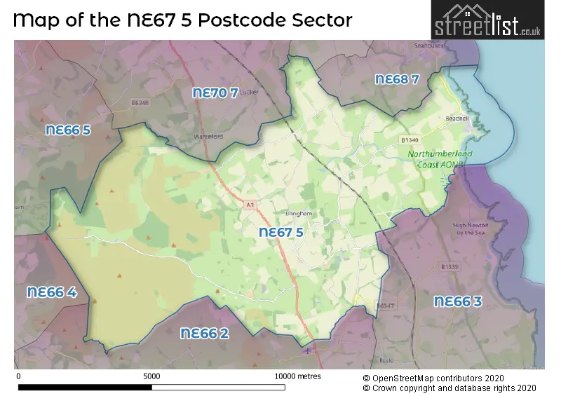
The NE67 5 postcode sector is within the county of Northumberland.
Did you know? According to the 2021 Census, the NE67 5 postcode sector is home to a bustling 877 residents!
Given that each sector allows for 400 unique postcode combinations. Letters C, I, K, M, O and V are not allowed in the last two letters of a postcode. With 109 postcodes already in use, this leaves 291 units available.
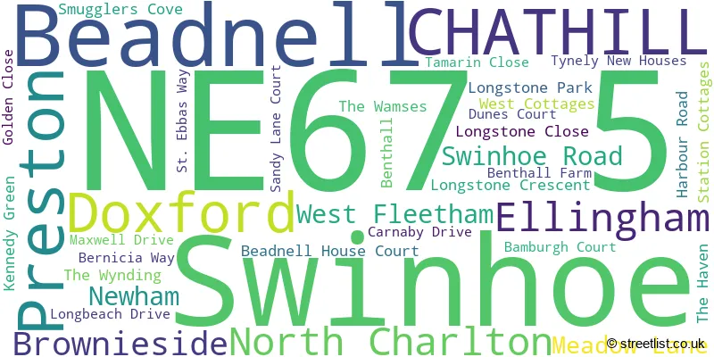
The largest settlement in the NE67 5 postal code is Beadnell followed by CHATHILL, and Ellingham.
The NE67 5 Postcode shares a border with NE66 2 (ALNWICK, Shilbottle, Alnmouth), NE66 3 (Longhoughton, Lesbury, Embleton), NE66 4 (Whittingham, Powburn, Glanton), NE66 5 (Chatton, Chillingham), NE68 7 (SEAHOUSES, North Sunderland), NE69 7 (BAMBURGH) and NE70 7 (BELFORD, Waren Mill, Lucker).
The sector is within the post town of CHATHILL.
NE67 5 is a postcode sector within the NE67 postcode district which is within the NE Newcastle upon Tyne postcode area.
The Royal Mail delivery office for the NE67 5 postal sector is the Alnwick Delivery Office.
The area of the NE67 5 postcode sector is 38.26 square miles which is 99.10 square kilometres or 24,488.04 square acres.
The NE67 5 postcode sector is crossed by the A1 Major A road.
Waterways within the NE67 5 postcode sector include the Harehope Burn, Red Burn, Cragcleugh Burn, Black Burn.

Map of the NE67 5 Postcode Sector
Explore the NE67 5 postcode sector by using our free interactive map.
| N | E | 6 | 7 | - | 5 | X | X |
| N | E | 6 | 7 | Space | 5 | Letter | Letter |
Official List of Streets
CHATHILL (3 Streets)
Beadnell (20 Streets)
Ellingham (3 Streets)
Doxford (1 Streets)
Unofficial Streets or Alternative Spellings
Weather Forecast for NE67 5
Press Button to Show Forecast for Beadnell Bay (Beach)
| Time Period | Icon | Description | Temperature | Rain Probability | Wind |
|---|---|---|---|---|---|
| 00:00 to 03:00 | Cloudy | 12.0°C (feels like 11.0°C) | 5.00% | SSW 4 mph | |
| 03:00 to 06:00 | Cloudy | 12.0°C (feels like 11.0°C) | 5.00% | SSW 4 mph | |
| 06:00 to 09:00 | Cloudy | 14.0°C (feels like 13.0°C) | 5.00% | SSW 4 mph | |
| 09:00 to 12:00 | Cloudy | 16.0°C (feels like 16.0°C) | 7.00% | S 4 mph | |
| 12:00 to 15:00 | Cloudy | 17.0°C (feels like 16.0°C) | 5.00% | SSE 9 mph | |
| 15:00 to 18:00 | Cloudy | 16.0°C (feels like 14.0°C) | 4.00% | SSE 11 mph | |
| 18:00 to 21:00 | Cloudy | 16.0°C (feels like 15.0°C) | 4.00% | SSE 7 mph | |
| 21:00 to 00:00 | Partly cloudy (night) | 13.0°C (feels like 11.0°C) | 2.00% | S 9 mph |
Press Button to Show Forecast for Beadnell Bay (Beach)
| Time Period | Icon | Description | Temperature | Rain Probability | Wind |
|---|---|---|---|---|---|
| 00:00 to 03:00 | Clear night | 12.0°C (feels like 10.0°C) | 1.00% | S 9 mph | |
| 03:00 to 06:00 | Partly cloudy (night) | 11.0°C (feels like 9.0°C) | 1.00% | SSW 7 mph | |
| 06:00 to 09:00 | Partly cloudy (day) | 13.0°C (feels like 12.0°C) | 2.00% | SSW 7 mph | |
| 09:00 to 12:00 | Partly cloudy (day) | 16.0°C (feels like 15.0°C) | 1.00% | SSE 7 mph | |
| 12:00 to 15:00 | Cloudy | 18.0°C (feels like 16.0°C) | 9.00% | SE 11 mph | |
| 15:00 to 18:00 | Light rain shower (day) | 17.0°C (feels like 15.0°C) | 30.00% | SSE 11 mph | |
| 18:00 to 21:00 | Sunny day | 16.0°C (feels like 14.0°C) | 4.00% | SSE 11 mph | |
| 21:00 to 00:00 | Clear night | 13.0°C (feels like 11.0°C) | 0.00% | SSE 11 mph |
Press Button to Show Forecast for Beadnell Bay (Beach)
| Time Period | Icon | Description | Temperature | Rain Probability | Wind |
|---|---|---|---|---|---|
| 00:00 to 03:00 | Partly cloudy (night) | 12.0°C (feels like 10.0°C) | 1.00% | SSE 11 mph | |
| 03:00 to 06:00 | Cloudy | 12.0°C (feels like 10.0°C) | 4.00% | SSE 11 mph | |
| 06:00 to 09:00 | Partly cloudy (day) | 13.0°C (feels like 11.0°C) | 1.00% | SSE 11 mph | |
| 09:00 to 12:00 | Cloudy | 15.0°C (feels like 13.0°C) | 4.00% | SSE 11 mph | |
| 12:00 to 15:00 | Cloudy | 15.0°C (feels like 13.0°C) | 5.00% | SE 13 mph | |
| 15:00 to 18:00 | Partly cloudy (day) | 15.0°C (feels like 13.0°C) | 5.00% | SE 13 mph | |
| 18:00 to 21:00 | Cloudy | 14.0°C (feels like 12.0°C) | 9.00% | SE 11 mph | |
| 21:00 to 00:00 | Cloudy | 13.0°C (feels like 11.0°C) | 11.00% | SSE 11 mph |
Press Button to Show Forecast for Beadnell Bay (Beach)
| Time Period | Icon | Description | Temperature | Rain Probability | Wind |
|---|---|---|---|---|---|
| 00:00 to 03:00 | Cloudy | 12.0°C (feels like 10.0°C) | 11.00% | SSE 11 mph | |
| 03:00 to 06:00 | Cloudy | 12.0°C (feels like 10.0°C) | 13.00% | SSE 9 mph | |
| 06:00 to 09:00 | Cloudy | 12.0°C (feels like 11.0°C) | 16.00% | SSE 9 mph | |
| 09:00 to 12:00 | Cloudy | 14.0°C (feels like 13.0°C) | 18.00% | SE 9 mph | |
| 12:00 to 15:00 | Light rain shower (day) | 14.0°C (feels like 13.0°C) | 38.00% | SE 11 mph | |
| 15:00 to 18:00 | Light rain shower (day) | 15.0°C (feels like 13.0°C) | 40.00% | SE 11 mph | |
| 18:00 to 21:00 | Light rain | 14.0°C (feels like 12.0°C) | 44.00% | SE 11 mph | |
| 21:00 to 00:00 | Cloudy | 12.0°C (feels like 10.0°C) | 10.00% | SSE 11 mph |
Schools and Places of Education Within the NE67 5 Postcode Sector
Ellingham Church of England Aided Primary School
Voluntary aided school
Ellingham, Chathill, Northumberland, NE67 5ET
Head: Mrs Diane Lakey
Ofsted Rating: Good
Inspection: 2023-06-06 (339 days ago)
Website: Visit Ellingham Church of England Aided Primary School Website
Phone: 01665589233
Number of Pupils: 38
House Prices in the NE67 5 Postcode Sector
| Type of Property | 2018 Average | 2018 Sales | 2017 Average | 2017 Sales | 2016 Average | 2016 Sales | 2015 Average | 2015 Sales |
|---|---|---|---|---|---|---|---|---|
| Detached | £360,944 | 9 | £327,032 | 14 | £234,815 | 24 | £338,533 | 15 |
| Semi-Detached | £191,567 | 11 | £242,031 | 16 | £200,215 | 16 | £228,068 | 14 |
| Terraced | £185,500 | 11 | £310,000 | 2 | £190,965 | 10 | £200,935 | 17 |
| Flats | £375,000 | 1 | £179,600 | 5 | £146,214 | 7 | £239,000 | 3 |
Important Postcodes NE67 5 in the Postcode Sector
NE67 5ET is the postcode for Ellingham C of E Aided First School, Ellingham
| The NE67 5 Sector is within these Local Authorities |
|
|---|---|
| The NE67 5 Sector is within these Counties |
|
| The NE67 5 Sector is within these Water Company Areas |
|
Tourist Attractions within the NE67 5 Postcode Area
We found 1 visitor attractions within the NE67 postcode area
| The Armstrong Household and Farming Museum |
|---|
| Museums & Art Galleries |
| Museum and / or Art Gallery |
| View The Armstrong Household and Farming Museum on Google Maps |