The OX11 postcode district is a postal district located in the OX Oxford postcode area with a population of 44,502 residents according to the 2021 England and Wales Census.
The area of the OX11 postcode district is 32.77 square miles which is 84.88 square kilometres or 20,973.56 acres.
Currently, the OX11 district has about 1108 postcode units spread across 5 geographic postcode sectors.
Given that each sector allows for 400 unique postcode combinations, the district has a capacity of 2,000 postcodes. With 1108 postcodes already in use, this leaves 892 units available.
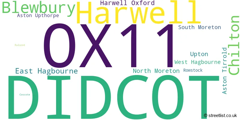
The largest settlement in the OX11 postal code is DIDCOT followed by Harwell, and Blewbury.
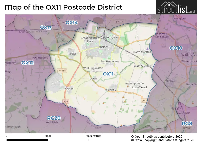
The OX11 Postcode shares a border with OX10 (WALLINGFORD, Benson, Cholsey), OX13 (Steventon, Southmoor, Marcham), OX14 (ABINGDON, Sutton Courtenay, Drayton), RG20 (Kingsclere, Woolton Hill, Compton) and RG8 (Pangbourne, Goring, Purley On Thames).
In the OX11 postcode district, the primary settlement is Didcot, located in the county of Oxfordshire in England. Other significant settlements in this district include Chilton, Coscote, Harwell, Harwell Oxford, Rowstock, and West Hagbourne. The most significant post town in this district is Didcot.
For the district OX11, we have data on 6 postcode sectors. Here's a breakdown: The sector OX11 0, covers Harwell and Chilton and Didcot in Oxfordshire. The sector OX11 1 is non-geographic. It's often designated for PO Boxes, large organisations, or special services. The sector OX11 6, covers Didcot and Harwell in Oxfordshire. The sector OX11 7, covers Didcot in Oxfordshire. The sector OX11 8, covers Didcot in Oxfordshire. The sector OX11 9, covers Blewbury and Didcot and East Hagbourne in Oxfordshire.

Map of the OX11 Postcode District
Explore the OX11 postcode district by using our free interactive map.
When it comes to local government, postal geography often disregards political borders. However, for a breakdown in the OX11 District: the district mostly encompasses the South Oxfordshire District (842 postcodes), and finally, the Vale of White Horse District area (308 postcodes).
Recent House Sales in OX11
| Date | Price | Address |
|---|---|---|
| 06/10/2023 | £372,000 | Norreys Road, Didcot, OX11 0AW |
| 06/10/2023 | £235,000 | Cottongrass Road, Harwell, Didcot, OX11 6GF |
| 05/10/2023 | £340,000 | Cherry Tree Road, Harwell, Didcot, OX11 6DG |
| 29/09/2023 | £465,000 | Bishops Orchard, East Hagbourne, Didcot, OX11 9JS |
| 26/09/2023 | £370,000 | Wessex Road, Didcot, OX11 8BT |
| 18/09/2023 | £244,000 | Medlock Grove, Didcot, OX11 7XY |
| 15/09/2023 | £350,000 | Mistletoe Mews, Harwell, Didcot, OX11 6DB |
| 14/09/2023 | £750,000 | Church Lane, Harwell, Didcot, OX11 0EZ |
| 13/09/2023 | £270,000 | Colne Drive, Didcot, OX11 7RZ |
| 08/09/2023 | £205,000 | Greenwood Way, Harwell, Didcot, OX11 6GY |
Weather Forecast for OX11
Press Button to Show Forecast for Blewbury
| Time Period | Icon | Description | Temperature | Rain Probability | Wind |
|---|---|---|---|---|---|
| 06:00 to 09:00 | Cloudy | 4.0°C (feels like 2.0°C) | 6.00% | ENE 7 mph | |
| 09:00 to 12:00 | Cloudy | 7.0°C (feels like 5.0°C) | 6.00% | ENE 9 mph | |
| 12:00 to 15:00 | Cloudy | 10.0°C (feels like 8.0°C) | 12.00% | ENE 7 mph | |
| 15:00 to 18:00 | Overcast | 10.0°C (feels like 9.0°C) | 16.00% | ENE 4 mph | |
| 18:00 to 21:00 | Cloudy | 9.0°C (feels like 8.0°C) | 12.00% | ENE 4 mph | |
| 21:00 to 00:00 | Cloudy | 6.0°C (feels like 4.0°C) | 14.00% | ENE 7 mph |
Press Button to Show Forecast for Blewbury
| Time Period | Icon | Description | Temperature | Rain Probability | Wind |
|---|---|---|---|---|---|
| 00:00 to 03:00 | Cloudy | 5.0°C (feels like 3.0°C) | 12.00% | ENE 7 mph | |
| 03:00 to 06:00 | Cloudy | 4.0°C (feels like 2.0°C) | 18.00% | ENE 7 mph | |
| 06:00 to 09:00 | Light rain | 5.0°C (feels like 2.0°C) | 51.00% | NE 7 mph | |
| 09:00 to 12:00 | Overcast | 8.0°C (feels like 5.0°C) | 23.00% | ENE 9 mph | |
| 12:00 to 15:00 | Overcast | 11.0°C (feels like 9.0°C) | 20.00% | ENE 9 mph | |
| 15:00 to 18:00 | Overcast | 11.0°C (feels like 9.0°C) | 23.00% | ENE 11 mph | |
| 18:00 to 21:00 | Light rain | 10.0°C (feels like 8.0°C) | 51.00% | ENE 9 mph | |
| 21:00 to 00:00 | Light rain | 8.0°C (feels like 6.0°C) | 53.00% | NE 11 mph |
Press Button to Show Forecast for Blewbury
| Time Period | Icon | Description | Temperature | Rain Probability | Wind |
|---|---|---|---|---|---|
| 00:00 to 03:00 | Heavy rain | 7.0°C (feels like 4.0°C) | 72.00% | NE 11 mph | |
| 03:00 to 06:00 | Heavy rain | 7.0°C (feels like 5.0°C) | 78.00% | NE 9 mph | |
| 06:00 to 09:00 | Light rain | 8.0°C (feels like 6.0°C) | 54.00% | NE 7 mph | |
| 09:00 to 12:00 | Heavy rain | 10.0°C (feels like 8.0°C) | 71.00% | SE 7 mph | |
| 12:00 to 15:00 | Light rain shower (day) | 11.0°C (feels like 9.0°C) | 44.00% | WSW 11 mph | |
| 15:00 to 18:00 | Light rain shower (day) | 11.0°C (feels like 9.0°C) | 43.00% | W 11 mph | |
| 18:00 to 21:00 | Light rain shower (day) | 10.0°C (feels like 8.0°C) | 35.00% | W 9 mph | |
| 21:00 to 00:00 | Cloudy | 8.0°C (feels like 6.0°C) | 7.00% | WSW 7 mph |
Where is the OX11 Postcode District?
The postcode district OX11 is located in Didcot, which is a town in Oxfordshire. Didcot is surrounded by several nearby towns. To the east, there is Wallingford, which is approximately 5.02 miles away. To the north, there is Abingdon, which is approximately 6.59 miles away. To the west, there is Wantage, which is approximately 8.09 miles away. To the northeast, there is Watlington, which is approximately 11.39 miles away. To the south, there is Thatcham, which is approximately 11.40 miles away. Finally, to the southeast, there is Reading, which is approximately 14.42 miles away. Didcot is also approximately 48.44 miles away from the center of London.
The district is within the post town of DIDCOT.
The sector has postcodes within the nation of England.
The OX11 Postcode District is in the Oxfordshire region of Berkshire, Buckinghamshire and Oxfordshire within the South East (England).
| Postcode Sector | Delivery Office |
|---|---|
| OX11 0 | Didcot Delivery Office |
| OX11 7 | Didcot Delivery Office |
| OX11 8 | Didcot Delivery Office |
| OX11 9 | Didcot Delivery Office |
| O | X | 1 | 1 | - | X | X | X |
| O | X | 1 | 1 | Space | Numeric | Letter | Letter |
Tourist Attractions within the Postcode Area
We found 1 visitor attractions within the OX11 postcode area
| Didcot Railway Centre |
|---|
| Museums & Art Galleries |
| Museum and / or Art Gallery |
| View Didcot Railway Centre on Google Maps |
Current Monthly Rental Prices
| # Bedrooms | Min Price | Max Price | Avg Price |
|---|---|---|---|
| £825 | £825 | £825 | |
| 1 | £915 | £1,000 | £955 |
| 2 | £1,250 | £2,780 | £1,633 |
| 3 | £1,450 | £1,800 | £1,625 |
| 4 | £1,800 | £4,000 | £2,471 |
Current House Prices
| # Bedrooms | Min Price | Max Price | Avg Price |
|---|---|---|---|
| £120,000 | £750,000 | £415,000 | |
| 1 | £99,950 | £285,000 | £173,746 |
| 2 | £75,000 | £685,000 | £273,512 |
| 3 | £220,000 | £795,000 | £422,109 |
| 4 | £390,000 | £1,750,000 | £631,115 |
| 5 | £500,000 | £1,995,000 | £955,000 |
| 6 | £1,500,000 | £1,500,000 | £1,500,000 |
| 17 | £6,000,000 | £6,000,000 | £6,000,000 |
Estate Agents who Operate in the OX11 District
| Logo | Name | Brand Name | Address | Contact Number | Total Properties |
|---|---|---|---|---|---|
 | Didcot | Chancellors | 212 Broadway, Didcot, OX11 8RS | 01235 642115 | 53 |
 | Didcot | Thomas Merrifield | 103 The Broadway, Didcot, OX11 8AL | 01235 642130 | 45 |
 | Didcot | Church Robinson | 6 Foxhall Road, Didcot, OX11 7AA | 01235 642151 | 30 |
 | Didcot | Allen & Harris | 135 Broadway, Didcot, Oxfordshire, OX11 8RQ | 01235 642137 | 28 |
 | Didcot | Hodsons | 220 Broadway, Didcot, OX11 8RS | 01235 642133 | 15 |
| Type of Property | 2018 Average | 2018 Sales | 2017 Average | 2017 Sales | 2016 Average | 2016 Sales | 2015 Average | 2015 Sales |
|---|---|---|---|---|---|---|---|---|
| Detached | £448,024 | 371 | £476,125 | 266 | £444,494 | 279 | £418,818 | 291 |
| Semi-Detached | £315,569 | 317 | £322,843 | 330 | £314,756 | 366 | £286,818 | 305 |
| Terraced | £271,969 | 183 | £281,007 | 236 | £269,730 | 215 | £249,659 | 269 |
| Flats | £214,769 | 202 | £209,520 | 122 | £193,726 | 105 | £176,077 | 97 |