The RG20 postcode district is a postal district located in the RG Reading postcode area with a population of 19,902 residents according to the 2021 England and Wales Census.
The area of the RG20 postcode district is 101.89 square miles which is 263.91 square kilometres or 65,212.65 acres.
Currently, the RG20 district has about 929 postcode units spread across 7 geographic postcode sectors.
Given that each sector allows for 400 unique postcode combinations, the district has a capacity of 2,800 postcodes. With 929 postcodes already in use, this leaves 1871 units available.
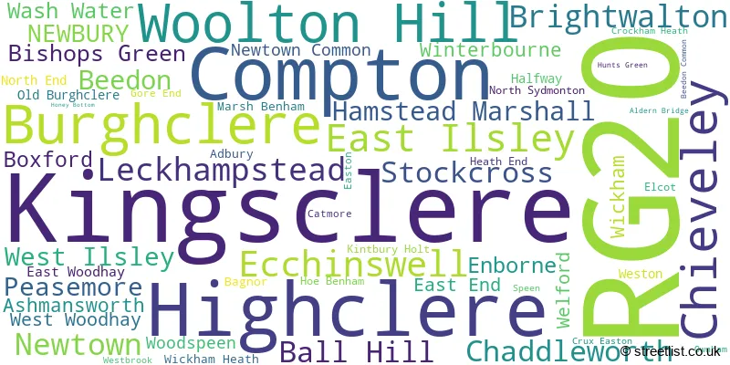
The largest settlement in the RG20 postal code is Kingsclere followed by Woolton Hill, and Compton.
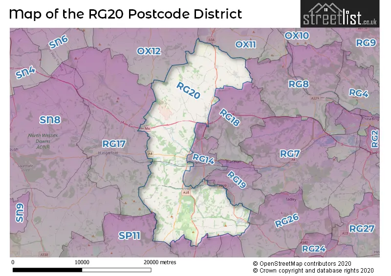
The RG20 Postcode shares a border with OX11 (DIDCOT, Harwell, Blewbury), RG14 (NEWBURY, Speen, Shaw), RG17 (HUNGERFORD, Lambourn, Kintbury), RG18 (THATCHAM, Hermitage, Cold Ash), RG19 (THATCHAM, Greenham, Headley), OX12 (WANTAGE, Grove, East Challow), RG28 (WHITCHURCH, Hurstbourne Priors, Laverstoke), SP11 (ANDOVER, Ludgershall, Picket Piece), RG25 (Overton, North Waltham, Upton Grey) and RG26 (TADLEY, Bramley, Baughurst).
The RG20 postcode district in the United Kingdom primarily consists of the settlement of Newbury in the county of Berkshire. Other significant settlements in this district include Ball Hill, Crockham Heath, East End, East Woodhay, Enborne, Gore End, Hamstead Marshall, Heath End, Kintbury Holt, Marsh Benham, North End, Wash Water, and West Woodhay. These settlements are located in either Hampshire or Berkshire counties. The postal town associated with the RG20 postcode district is Newbury.
For the district RG20, we have data on 7 postcode sectors. Here's a breakdown: The sector RG20 0, covers Ball Hill in Hampshire. The sector RG20 0, covers Hamstead Marshall and Enborne in Berkshire. The sector RG20 4, covers Ecchinswell and Kingsclere and Bishops Green in Hampshire. The sector RG20 5, covers Kingsclere in Hampshire. The sector RG20 6, covers Compton in Berkshire. The sector RG20 7, covers East Ilsley and Brightwalton and Chaddleworth and Peasemore and West Ilsley and Compton in Berkshire. The sector RG20 8, covers Chieveley and Leckhampstead in Berkshire. The sector RG20 9, covers Highclere and Burghclere and Woolton Hill in Hampshire.

Map of the RG20 Postcode District
Explore the RG20 postcode district by using our free interactive map.
When it comes to local government, postal geography often disregards political borders. However, for a breakdown in the RG20 District: the district mostly encompasses the West Berkshire (479 postcodes), and finally, the Basingstoke and Deane District (B) area (455 postcodes).
Recent House Sales in RG20
| Date | Price | Address |
|---|---|---|
| 20/10/2023 | £460,000 | George Street, Kingsclere, Newbury, RG20 5NH |
| 27/09/2023 | £335,000 | High Street, Compton, Newbury, RG20 6NJ |
| 25/09/2023 | £176,500 | Strokins Road, Kingsclere, Newbury, RG20 5RQ |
| 06/09/2023 | £845,000 | Main Street, West Ilsley, Newbury, RG20 7AJ |
| 04/09/2023 | £307,000 | Meadow Close, Compton, Newbury, RG20 6QQ |
| 25/08/2023 | £962,000 | Heatherwold, Newtown, Newbury, RG20 9BG |
| 25/08/2023 | £399,950 | Stockcross, Newbury, RG20 8JL |
| 18/08/2023 | £475,000 | Westons, Beedon, Newbury, RG20 8SL |
| 18/08/2023 | £290,000 | Fawconer Road, Kingsclere, Newbury, RG20 5RL |
| 18/08/2023 | £520,000 | Ecchinswell, Newbury, RG20 4TU |
Weather Forecast for RG20
Press Button to Show Forecast for Newbury
| Time Period | Icon | Description | Temperature | Rain Probability | Wind |
|---|---|---|---|---|---|
| 12:00 to 15:00 | Overcast | 9.0°C (feels like 7.0°C) | 13.00% | ENE 9 mph | |
| 15:00 to 18:00 | Cloudy | 11.0°C (feels like 9.0°C) | 12.00% | NE 9 mph | |
| 18:00 to 21:00 | Overcast | 10.0°C (feels like 7.0°C) | 18.00% | NNE 11 mph | |
| 21:00 to 00:00 | Heavy rain | 8.0°C (feels like 5.0°C) | 88.00% | NNE 11 mph |
Press Button to Show Forecast for Newbury
| Time Period | Icon | Description | Temperature | Rain Probability | Wind |
|---|---|---|---|---|---|
| 00:00 to 03:00 | Heavy rain | 7.0°C (feels like 4.0°C) | 84.00% | NNE 11 mph | |
| 03:00 to 06:00 | Heavy rain | 7.0°C (feels like 3.0°C) | 88.00% | N 13 mph | |
| 06:00 to 09:00 | Heavy rain | 6.0°C (feels like 3.0°C) | 89.00% | N 11 mph | |
| 09:00 to 12:00 | Heavy rain | 7.0°C (feels like 4.0°C) | 82.00% | NW 11 mph | |
| 12:00 to 15:00 | Light rain | 9.0°C (feels like 6.0°C) | 53.00% | WNW 11 mph | |
| 15:00 to 18:00 | Cloudy | 10.0°C (feels like 8.0°C) | 12.00% | W 9 mph | |
| 18:00 to 21:00 | Cloudy | 10.0°C (feels like 8.0°C) | 8.00% | WSW 7 mph | |
| 21:00 to 00:00 | Partly cloudy (night) | 7.0°C (feels like 5.0°C) | 4.00% | SW 7 mph |
Press Button to Show Forecast for Newbury
| Time Period | Icon | Description | Temperature | Rain Probability | Wind |
|---|---|---|---|---|---|
| 00:00 to 03:00 | Clear night | 5.0°C (feels like 3.0°C) | 2.00% | SW 7 mph | |
| 03:00 to 06:00 | Clear night | 4.0°C (feels like 2.0°C) | 1.00% | SSW 4 mph | |
| 06:00 to 09:00 | Sunny day | 6.0°C (feels like 4.0°C) | 1.00% | S 7 mph | |
| 09:00 to 12:00 | Partly cloudy (day) | 11.0°C (feels like 9.0°C) | 2.00% | S 11 mph | |
| 12:00 to 15:00 | Cloudy | 13.0°C (feels like 10.0°C) | 6.00% | S 13 mph | |
| 15:00 to 18:00 | Cloudy | 14.0°C (feels like 11.0°C) | 5.00% | S 13 mph | |
| 18:00 to 21:00 | Sunny day | 12.0°C (feels like 10.0°C) | 2.00% | S 9 mph | |
| 21:00 to 00:00 | Clear night | 8.0°C (feels like 6.0°C) | 3.00% | SSE 7 mph |
Press Button to Show Forecast for Newbury
| Time Period | Icon | Description | Temperature | Rain Probability | Wind |
|---|---|---|---|---|---|
| 00:00 to 03:00 | Clear night | 8.0°C (feels like 5.0°C) | 3.00% | SE 7 mph | |
| 03:00 to 06:00 | Clear night | 7.0°C (feels like 5.0°C) | 3.00% | SE 7 mph | |
| 06:00 to 09:00 | Sunny day | 8.0°C (feels like 6.0°C) | 4.00% | SE 9 mph | |
| 09:00 to 12:00 | Sunny day | 13.0°C (feels like 11.0°C) | 7.00% | SE 11 mph | |
| 12:00 to 15:00 | Partly cloudy (day) | 15.0°C (feels like 13.0°C) | 10.00% | SE 13 mph | |
| 15:00 to 18:00 | Cloudy | 16.0°C (feels like 13.0°C) | 9.00% | SSE 11 mph | |
| 18:00 to 21:00 | Partly cloudy (day) | 14.0°C (feels like 13.0°C) | 5.00% | SE 9 mph | |
| 21:00 to 00:00 | Cloudy | 11.0°C (feels like 10.0°C) | 8.00% | SE 7 mph |
Where is the RG20 Postcode District?
The postcode district for RG20 is located in the town of Newbury. It is surrounded by several nearby towns: Thatcham is located to the East, Hungerford to the West, Tadley to the South East, Wantage to the North, Whitchurch to the South, and Wallingford to the North East. Additionally, the postcode district is approximately 53.12516091258986 miles away from the centre of London.
The district is within the post town of NEWBURY.
The sector has postcodes within the nation of England.
The RG20 Postcode District is covers the following regions.
- North Hampshire - Hampshire and Isle of Wight - South East (England)
- Berkshire - Berkshire, Buckinghamshire and Oxfordshire - South East (England)
| Postcode Sector | Delivery Office |
|---|---|
| RG20 0 | Newbury Delivery Office |
| RG20 4 | Newbury Delivery Office |
| RG20 5 | Newbury Delivery Office |
| RG20 5 | Kingsclere Scale Payment Delivery Office |
| RG20 6 | Newbury Delivery Office |
| RG20 6 | Compton Scale Payment Delivery Office |
| RG20 7 | Newbury Delivery Office |
| RG20 7 | Compton Scale Payment Delivery Office |
| RG20 8 | Newbury Delivery Office |
| RG20 9 | Newbury Delivery Office |
| R | G | 2 | 0 | - | X | X | X |
| R | G | 2 | 0 | Space | Numeric | Letter | Letter |
Tourist Attractions within the Postcode Area
We found 1 visitor attractions within the RG20 postcode area
| Sandham Memorial Chapel |
|---|
| Places of Worship |
| Place of Worship (still in use) |
| View Sandham Memorial Chapel on Google Maps |
Current Monthly Rental Prices
| # Bedrooms | Min Price | Max Price | Avg Price |
|---|---|---|---|
| 2 | £850 | £1,450 | £1,238 |
| 3 | £1,500 | £2,750 | £1,950 |
| 4 | £1,695 | £4,500 | £3,408 |
| 5 | £2,750 | £4,750 | £3,924 |
| 6 | £4,850 | £4,850 | £4,850 |
| 7 | £4,750 | £4,750 | £4,750 |
Current House Prices
| # Bedrooms | Min Price | Max Price | Avg Price |
|---|---|---|---|
| £200,000 | £3,750,000 | £902,273 | |
| 1 | £195,000 | £300,000 | £265,000 |
| 2 | £135,000 | £725,000 | £299,184 |
| 3 | £250,000 | £1,200,000 | £538,814 |
| 4 | £495,000 | £1,850,000 | £811,406 |
| 5 | £795,000 | £3,000,000 | £1,299,688 |
| 6 | £1,150,000 | £2,750,000 | £1,980,000 |
| 7 | £2,900,000 | £2,900,000 | £2,900,000 |
| 8 | £1,250,000 | £6,750,000 | £4,916,667 |
| 11 | £5,750,000 | £5,750,000 | £5,750,000 |
Estate Agents who Operate in the RG20 District
| Logo | Name | Brand Name | Address | Contact Number | Total Properties |
|---|---|---|---|---|---|
 | Newbury | Jones Robinson | 118 Bartholomew Street Newbury, RG14 5DT | 01639 505688 | 14 |
 | Newbury | Carter Jonas | 51 Northbrook Street, Newbury, RG14 1DT | 01635 015779 | 12 |
 | Newbury | Strutt & Parker | 55 Northbrook Street, Newbury, RG14 1AN | 01635 886918 | 12 |
 | Newbury | Downer & Co | 44 Cheap Street, Newbury, RG14 5BX | 01635 015340 | 11 |
 | Newbury | Savills | 1 - 3 The Broadway, Newbury, RG14 1AS | 01635 884746 | 10 |
- Ashmansworth
- Bagnor
- Ball Hill
- Beedon
- Bishop's Green
- Boxford
- Brightwalton
- Burghclere Common
- Burghclere
- Chaddleworth
- Chieveley
- Clapton
- Compton
- Crockham Heath
- Earlstone Common
- East End
- East Ilsley
- Easton
- Ecchinswell
- Enborne Row
- Farnborough
- Halfway
- Hamstead Marshall
- Headley
- Highclere
- Inkpen
- Kingsclere
- Kintbury
- Leckhampstead
- Newbury
- Newtown
- North End
- North Heath
- Old Burghclere
- Peasemore
- Penwood
- Stanmore
- Stockcross
- Tot Hill
- Wash Water
- West Ilsley
- Weston
- Wickham Heath
- Wickham
- Winterbourne
- Woodspeen
- Woolton Hill
- World's End
| Type of Property | 2018 Average | 2018 Sales | 2017 Average | 2017 Sales | 2016 Average | 2016 Sales | 2015 Average | 2015 Sales |
|---|---|---|---|---|---|---|---|---|
| Detached | £742,350 | 128 | £671,280 | 136 | £693,641 | 135 | £629,742 | 126 |
| Semi-Detached | £413,301 | 43 | £428,127 | 68 | £387,277 | 67 | £386,613 | 62 |
| Terraced | £349,491 | 34 | £342,749 | 39 | £288,285 | 55 | £306,795 | 46 |
| Flats | £231,869 | 8 | £224,750 | 12 | £196,111 | 22 | £180,094 | 10 |