Given that each sector allows for 400 unique postcode combinations. Letters C, I, K, M, O and V are not allowed in the last two letters of a postcode. With 131 postcodes already in use, this leaves 269 units available.
The PA10 2 postal code covers the settlement of Kilbarchan.
The PA10 2 Postcode shares a border with PA9 1 (Howwood), PA5 0 (JOHNSTONE), PA11 3 (BRIDGE OF WEIR, Quarrier's Village), PA12 4 (LOCHWINNOCH) and PA5 8 (JOHNSTONE, Brookfield).
The sector is within the post town of JOHNSTONE.
PA10 2 is a postcode sector within the PA1 postcode district which is within the PA Paisley postcode area.
The Royal Mail delivery office for the PA10 2 postal sector is the Paisley Delivery Office.
The area of the PA10 2 postcode sector is 8.18 square miles which is 21.19 square kilometres or 5,237.12 square acres.


Map of the PA10 2 Postcode Sector
Explore the PA10 2 postcode sector by using our free interactive map.
| P | A | 1 | 0 | - | 2 | X | X |
| P | A | 1 | 0 | Space | 2 | Letter | Letter |
Official List of Streets
Kilbarchan (74 Streets)
Unofficial Streets or Alternative Spellings
JOHNSTONE
COCHRANEMILL ROAD HALLHILL CRESCENT HALLHILL DRIVE LONGMEADOW BARNSCROFT BREWERY ROAD CUNINGHAME ROAD DALRY AND NORTH JOHNSTONE RAIL TRAIL JOHNSTONE AND HOWWOOD BYPASS LISMORE GARDENS LOCHER ROAD MELFORT GARDENS TOPPERSFIELD WEAVERS COURTBrookfield
BRIDGE OF WEIR ROADBRIDGE OF WEIR
KILBARCHAN ROADHowwood
BEITH ROAD STATION ROADLOCHWINNOCH
BRIDESMILL ROAD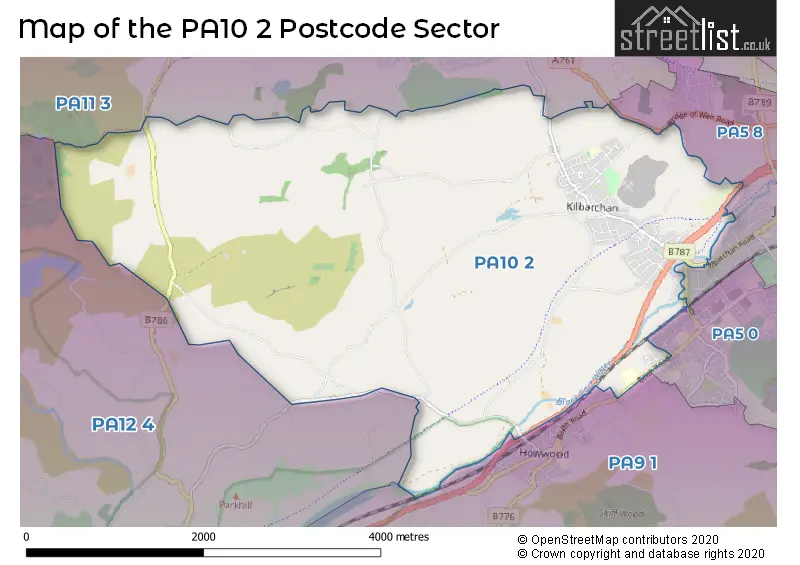
| The PA10 2 Sector is within these Local Authorities | |
|---|---|
| The PA10 2 Sector is within these Counties | |
| The PA10 2 Sector is within these Water Company Areas |