The PA1 postcode district is a postal district located in the PA Paisley postcode area with a population of 22,253 residents according to the 2011 Scotland Census.
The area of the PA1 postcode district is 2.96 square miles which is 7.67 square kilometres or 1,895.19 acres.
Currently, the PA1 district has about 590 postcode units spread across 20 geographic postcode sectors.
Given that each sector allows for 400 unique postcode combinations, the district has a capacity of 8,000 postcodes. With 590 postcodes already in use, this leaves 7410 units available.
The PA1 postal code covers the settlement of PAISLEY.
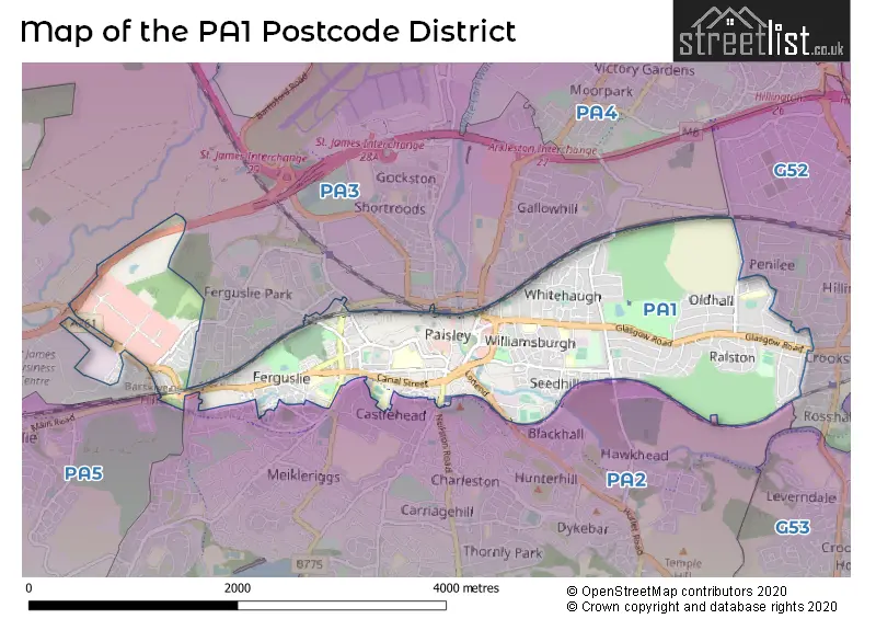
The PA1 Postcode shares a border with PA2 (PAISLEY), G52 (GLASGOW, Hillington Park) and PA3 (PAISLEY, Linwood, Abbotsinch).
The primary settlement in the PA1 postcode district is Paisley, located in the county of Renfrewshire in Scotland. There is also a significant settlement called Millarston in the same district. The main post town for the PA1 postcode district is Paisley.
For the district PA1, we have data on 3 postcode sectors. Here's a breakdown: The sector PA1 1, covers Paisley in Renfrewshire. The sector PA1 2, covers Paisley in Renfrewshire. The sector PA1 3, covers Paisley in Renfrewshire.

Map of the PA1 Postcode District
Explore the PA1 postcode district by using our free interactive map.
When it comes to local government, postal geography often disregards political borders. However, for a breakdown in the PA1 District: the district mostly encompasses the Renfrewshire area with a total of 603 postcodes.
Where is the PA1 Postcode District?
The postcode district PA1 is located in Paisley. Paisley is surrounded by several nearby towns, including Renfrew to the North, Edinburgh to the East, Johnstone to the West, Clydebank to the North East, Bishopton to the North West, and Aberdeen to the South East. Additionally, the distance from PA1 to London is approximately 347.69 miles.
The district is within the post town of PAISLEY.
The sector has postcodes within the nation of Scotland.
The PA1 Postcode District is in the Inverclyde, East Renfrewshire and Renfrewshire region of West Central Scotland within the Scotland.
Weather Forecast for PA1
Press Button to Show Forecast for Oldhall
| Time Period | Icon | Description | Temperature | Rain Probability | Wind |
|---|---|---|---|---|---|
| 03:00 to 06:00 | Heavy rain shower (night) | 14.0°C (feels like 14.0°C) | 58.00% | ENE 7 mph | |
| 06:00 to 09:00 | Light rain | 14.0°C (feels like 13.0°C) | 51.00% | ENE 7 mph | |
| 09:00 to 12:00 | Light rain | 15.0°C (feels like 13.0°C) | 53.00% | ENE 9 mph | |
| 12:00 to 15:00 | Light rain | 16.0°C (feels like 14.0°C) | 53.00% | ENE 11 mph | |
| 15:00 to 18:00 | Heavy rain | 16.0°C (feels like 14.0°C) | 77.00% | E 11 mph | |
| 18:00 to 21:00 | Heavy rain | 15.0°C (feels like 14.0°C) | 82.00% | E 9 mph | |
| 21:00 to 00:00 | Light rain | 14.0°C (feels like 13.0°C) | 53.00% | ENE 7 mph |
Press Button to Show Forecast for Oldhall
| Time Period | Icon | Description | Temperature | Rain Probability | Wind |
|---|---|---|---|---|---|
| 00:00 to 03:00 | Cloudy | 13.0°C (feels like 13.0°C) | 12.00% | ENE 4 mph | |
| 03:00 to 06:00 | Cloudy | 13.0°C (feels like 12.0°C) | 10.00% | ENE 4 mph | |
| 06:00 to 09:00 | Cloudy | 13.0°C (feels like 12.0°C) | 6.00% | ENE 4 mph | |
| 09:00 to 12:00 | Cloudy | 15.0°C (feels like 14.0°C) | 6.00% | ENE 7 mph | |
| 12:00 to 15:00 | Cloudy | 18.0°C (feels like 17.0°C) | 6.00% | ENE 9 mph | |
| 15:00 to 18:00 | Cloudy | 19.0°C (feels like 18.0°C) | 9.00% | E 9 mph | |
| 18:00 to 21:00 | Light rain shower (day) | 17.0°C (feels like 16.0°C) | 32.00% | ENE 9 mph | |
| 21:00 to 00:00 | Partly cloudy (night) | 14.0°C (feels like 13.0°C) | 5.00% | ENE 9 mph |
Press Button to Show Forecast for Oldhall
| Time Period | Icon | Description | Temperature | Rain Probability | Wind |
|---|---|---|---|---|---|
| 00:00 to 03:00 | Overcast | 12.0°C (feels like 10.0°C) | 9.00% | ENE 9 mph | |
| 03:00 to 06:00 | Overcast | 11.0°C (feels like 10.0°C) | 9.00% | NE 7 mph | |
| 06:00 to 09:00 | Overcast | 11.0°C (feels like 10.0°C) | 10.00% | NE 7 mph | |
| 09:00 to 12:00 | Cloudy | 14.0°C (feels like 12.0°C) | 5.00% | ENE 9 mph | |
| 12:00 to 15:00 | Cloudy | 18.0°C (feels like 16.0°C) | 6.00% | ENE 9 mph | |
| 15:00 to 18:00 | Cloudy | 19.0°C (feels like 18.0°C) | 12.00% | ENE 9 mph | |
| 18:00 to 21:00 | Partly cloudy (day) | 18.0°C (feels like 16.0°C) | 9.00% | ENE 9 mph | |
| 21:00 to 00:00 | Clear night | 14.0°C (feels like 13.0°C) | 3.00% | NE 9 mph |
Press Button to Show Forecast for Oldhall
| Time Period | Icon | Description | Temperature | Rain Probability | Wind |
|---|---|---|---|---|---|
| 00:00 to 03:00 | Cloudy | 12.0°C (feels like 10.0°C) | 5.00% | NE 9 mph | |
| 03:00 to 06:00 | Cloudy | 11.0°C (feels like 9.0°C) | 7.00% | NE 7 mph | |
| 06:00 to 09:00 | Cloudy | 12.0°C (feels like 10.0°C) | 8.00% | NE 9 mph | |
| 09:00 to 12:00 | Partly cloudy (day) | 15.0°C (feels like 13.0°C) | 5.00% | NE 9 mph | |
| 12:00 to 15:00 | Partly cloudy (day) | 18.0°C (feels like 16.0°C) | 6.00% | NE 9 mph | |
| 15:00 to 18:00 | Sunny day | 19.0°C (feels like 17.0°C) | 11.00% | NE 9 mph | |
| 18:00 to 21:00 | Sunny day | 18.0°C (feels like 16.0°C) | 13.00% | NNE 9 mph | |
| 21:00 to 00:00 | Clear night | 14.0°C (feels like 13.0°C) | 10.00% | NNE 7 mph |
Press Button to Show Forecast for Oldhall
| Time Period | Icon | Description | Temperature | Rain Probability | Wind |
|---|---|---|---|---|---|
| 00:00 to 03:00 | Partly cloudy (night) | 12.0°C (feels like 11.0°C) | 6.00% | NNE 7 mph | |
| 03:00 to 06:00 | Overcast | 11.0°C (feels like 10.0°C) | 9.00% | NNE 4 mph | |
| 06:00 to 09:00 | Cloudy | 12.0°C (feels like 11.0°C) | 9.00% | N 7 mph | |
| 09:00 to 12:00 | Partly cloudy (day) | 14.0°C (feels like 13.0°C) | 5.00% | NNE 7 mph | |
| 12:00 to 15:00 | Partly cloudy (day) | 17.0°C (feels like 16.0°C) | 3.00% | NNE 7 mph | |
| 15:00 to 18:00 | Partly cloudy (day) | 19.0°C (feels like 17.0°C) | 5.00% | N 7 mph | |
| 18:00 to 21:00 | Sunny day | 18.0°C (feels like 16.0°C) | 4.00% | N 7 mph | |
| 21:00 to 00:00 | Clear night | 14.0°C (feels like 13.0°C) | 2.00% | WSW 7 mph |
Postcode Sectors within the PA1 District
| Postcode Sector | Delivery Office |
|---|---|
| PA1 1 | Paisley Delivery Office |
| PA1 2 | Paisley Delivery Office |
| PA1 3 | Paisley Delivery Office |
| P | A | 1 | - | X | X | X |
| P | A | 1 | Space | Numeric | Letter | Letter |
Current Monthly Rental Prices
| # Bedrooms | Min Price | Max Price | Avg Price |
|---|---|---|---|
| 1 | £430 | £625 | £535 |
| 2 | £650 | £750 | £700 |
| 3 | £775 | £1,350 | £1,063 |
| 4 | £1,500 | £2,000 | £1,750 |
Current House Prices
| # Bedrooms | Min Price | Max Price | Avg Price |
|---|---|---|---|
| £18,000 | £18,000 | £18,000 | |
| 1 | £25,000 | £150,000 | £68,421 |
| 2 | £65,000 | £239,000 | £138,164 |
| 3 | £70,000 | £310,000 | £209,238 |
| 4 | £209,995 | £530,000 | £330,499 |
| 5 | £280,000 | £380,000 | £338,333 |
Estate Agents who Operate in the PA1 District
| Logo | Name | Brand Name | Address | Contact Number | Total Properties |
|---|---|---|---|---|---|
 | Paisley | Countrywide | 5 Causeyside Street, Paisley, Renfrewshire, PA1 1UW | 0141 673 0483 | 8 |
 | Paisley | Cochran Dickie Estate Agency | 21 Moss Street, Paisley, PA1 1BX | 0141 673 7097 | 7 |
 | Glasgow | Let Property Sales & Management | 10 Victoria Circus, Glasgow, G12 9JY | 0141 673 7973 | 5 |
 | Paisley | Slater Hogg & Howison | 17-19 Gauze Street Paisley PA1 1ES | 0141 673 4251 | 4 |
 | Paisley | Auction House Scotland | Auction House Scotland Office 2 Craigs Business Centre Macdowall Street Paisley Renfrewshire PA3 2NB | 0141 673 7275 | 4 |