Given that each sector allows for 400 unique postcode combinations. Letters C, I, K, M, O and V are not allowed in the last two letters of a postcode. With 224 postcodes already in use, this leaves 176 units available.
The PA14 5 postal code covers the settlement of PORT GLASGOW.
The PA14 5 Postcode shares a border with PA15 3 (GREENOCK), PA13 4 (KILMACOLM), PA15 2 (GREENOCK) and PA14 6 (PORT GLASGOW, Langbank).
The sector is within the post town of PORT GLASGOW.
PA14 5 is a postcode sector within the PA1 postcode district which is within the PA Paisley postcode area.
The Royal Mail delivery office for the PA14 5 postal sector is the unknown.
The area of the PA14 5 postcode sector is 2.05 square miles which is 5.30 square kilometres or 1,309.24 square acres.


Map of the PA14 5 Postcode Sector
Explore the PA14 5 postcode sector by using our free interactive map.
| P | A | 1 | 4 | - | 5 | X | X |
| P | A | 1 | 4 | Space | 5 | Letter | Letter |
Official List of Streets
PORT GLASGOW (139 Streets)
Unofficial Streets or Alternative Spellings
PORT GLASGOW
BARDRAINNEY AVENUE HIGH CARNEGIE ROAD KILMACOLM ROADInchinnan
GREENOCK ROADLangbank
GREENOCK ROADKILMACOLM,
AUCHENBOTHIE ROAD AUCHENFOIL LANE AUCHENLECK LANE AUCHENLECK ROAD AUCHMOUNTAIN ROAD BENCLUTHA BURNHEAD LANE BURNHEAD ROAD CHAPELTON STREET CLUME BRAE CLUNE PARK STREET COMET ROAD COMET ROUNDABOUT DUCHAL STREET DYKENEUK ROAD GARELOCH LANE GLEN ROUNDABOUT GRYFE ROAD HUNTLY PLACE KINGSTON ROUNDABOUT KNOCKNAIR STREET LOWER BOUVERIE STREET LURG STREET MIRRENS SHORE NEWARK PLACE NEWARK ROUNDABOUT ROSNEATH ROAD SELKIRK ROAD WATER STREET WILLIAM STREET WILLISONS LANEGREENOCK
CALEDONIA DRIVE EAST STREET POPLAR STREET PORT GLASGOW ROAD SCOTT WAY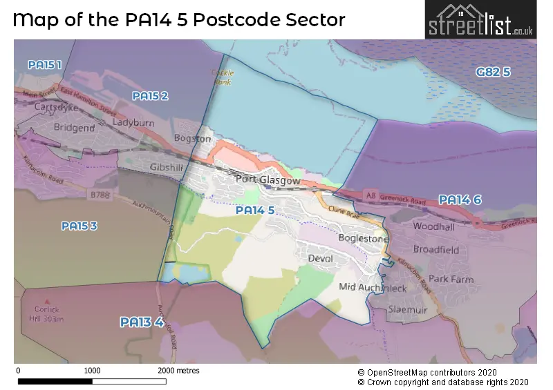
| The PA14 5 Sector is within these Local Authorities | |
|---|---|
| The PA14 5 Sector is within these Counties | |
| The PA14 5 Sector is within these Water Company Areas |