Given that each sector allows for 400 unique postcode combinations. Letters C, I, K, M, O and V are not allowed in the last two letters of a postcode. With 178 postcodes already in use, this leaves 222 units available.
The PA15 4 postal code covers the settlement of GREENOCK.
The PA15 4 Postcode shares a border with PA15 3 (GREENOCK), PA15 1 (GREENOCK), PA15 2 (GREENOCK), PA16 8 (GREENOCK) and PA16 9 (GREENOCK).
The sector is within the post town of GREENOCK.
PA15 4 is a postcode sector within the PA1 postcode district which is within the PA Paisley postcode area.
The Royal Mail delivery office for the PA15 4 postal sector is the unknown.
The area of the PA15 4 postcode sector is 0.67 square miles which is 1.74 square kilometres or 429.19 square acres.

Map of the PA15 4 Postcode Sector
Explore the PA15 4 postcode sector by using our free interactive map.
| P | A | 1 | 5 | - | 4 | X | X |
| P | A | 1 | 5 | Space | 4 | Letter | Letter |
Official List of Streets
GREENOCK (78 Streets)
Unofficial Streets or Alternative Spellings
GREENOCK
BARNHILL STREET BEARHOPE STREET BELVILLE AVENUE BRACHELSTON STREET CARNOCK STREET DUNLOP STREET GRANT STREET INVERKIP ROAD INVERKIP STREET MAIN STREET NEWTON STREET OLD LARGS ROAD ORCHARD STREET PAPERMILL ROAD RATHO STREET SIR MICHAEL STREET TERRACE ROAD WALLACE STREET BERRYYARDS ROAD CRESCENT STREET EAST STEWART STREET EMPRESS COURT HILL STREET HOLE FARM ROAD INGLESTON PARK KILMUN ROAD ORANGEFIELD PEAT ROAD SCOTT STREET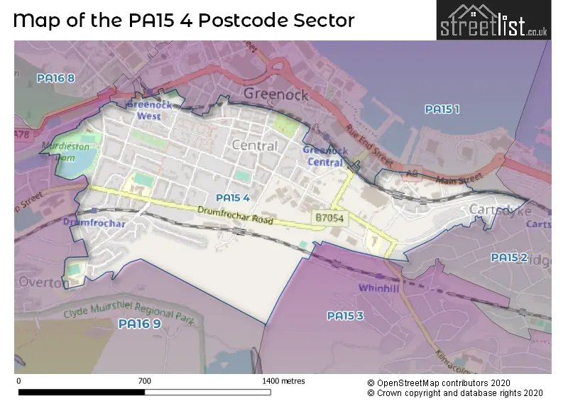
| The PA15 4 Sector is within these Local Authorities | |
|---|---|
| The PA15 4 Sector is within these Counties | |
| The PA15 4 Sector is within these Water Company Areas |