The PE12 postcode district is a postal district located in the PE Peterborough postcode area with a population of 41,880 residents according to the 2021 England and Wales Census.
The area of the PE12 postcode district is 170.35 square miles which is 441.22 square kilometres or 109,026.71 acres.
Currently, the PE12 district has about 1187 postcode units spread across 5 geographic postcode sectors.
Given that each sector allows for 400 unique postcode combinations, the district has a capacity of 2,000 postcodes. With 1187 postcodes already in use, this leaves 813 units available.
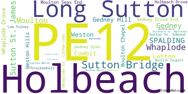
The largest settlement in the PE12 postal code is Holbeach followed by Long Sutton, and Sutton Bridge.
The postcode area has a boundary with The Wash.
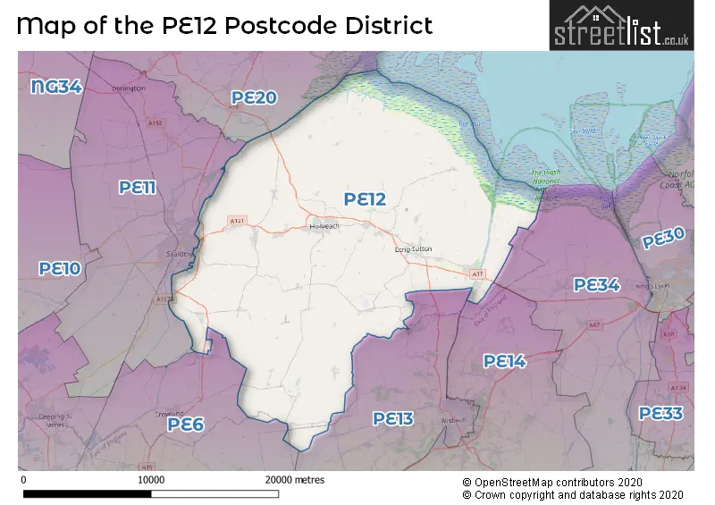
The PE12 Postcode shares a border with PE34 (Terrington St. Clement, Clenchwarton, West Lynn), PE13 (WISBECH, Leverington, Wisbech St. Mary), PE14 (Elm, Upwell, WISBECH), PE6 (Market Deeping, Deeping St. James, Crowland) and PE11 (SPALDING, Pinchbeck, Donington).
In the PE12 postcode district in Lincolnshire, England, the primary settlement is Gedney with a count of 41. Other significant settlements include Gedney Dyke, Gedney Hill, Holbeach Drove, Moulton Chapel, Moulton Eaugate, Sutton St. Edmund, Sutton St. James, Throckenholt, and Whaplode Drove. The most significant post town in this district is Spalding.
For the district PE12, we have data on 6 postcode sectors. Here's a breakdown: The sector PE12 0, covers Sutton St. James and Gedney and Gedney Hill and Whaplode Drove in Lincolnshire. The sector PE12 2 is non-geographic. It's often designated for PO Boxes, large organisations, or special services. The sector PE12 6, covers Whaplode and Moulton and Spalding and Cowbit and Weston in Lincolnshire. The sector PE12 7, covers Holbeach in Lincolnshire. The sector PE12 8, covers Holbeach in Lincolnshire. The sector PE12 9, covers Long Sutton and Sutton Bridge and Lutton in Lincolnshire.

Map of the PE12 Postcode District
Explore the PE12 postcode district by using our free interactive map.
When it comes to local government, postal geography often disregards political borders. However, for a breakdown in the PE12 District: the district mostly encompasses the South Holland District (1238 postcodes), and finally, the Fenland District area (3 postcodes).
Recent House Sales in PE12
| Date | Price | Address |
|---|---|---|
| 27/10/2023 | £190,000 | St Polycarps Drive, Holbeach Drove, Spalding, PE12 0SF |
| 18/10/2023 | £360,000 | Barrier Bank, Cowbit, Spalding, PE12 6AL |
| 13/10/2023 | £210,000 | Daniels Gate, Long Sutton, Spalding, PE12 9DN |
| 29/09/2023 | £70,000 | Peacock Court, Sutton Bridge, Spalding, PE12 9SB |
| 27/09/2023 | £125,000 | Carrington Road, Moulton Seas End, Spalding, PE12 6LS |
| 21/09/2023 | £110,000 | Bridge Road, Sutton Bridge, Spalding, PE12 9SH |
| 18/09/2023 | £240,000 | John Swains Way, Long Sutton, Spalding, PE12 9DQ |
| 15/09/2023 | £212,000 | Chalk Lane, Sutton Bridge, Spalding, PE12 9YF |
| 13/09/2023 | £198,000 | Longdon Close, Sutton Bridge, Spalding, PE12 9QX |
| 13/09/2023 | £350,000 | Rectory Lane, Gedney, Spalding, PE12 0EA |
Weather Forecast for PE12
Press Button to Show Forecast for Holbeach
| Time Period | Icon | Description | Temperature | Rain Probability | Wind |
|---|---|---|---|---|---|
| 03:00 to 06:00 | Clear night | 1.0°C (feels like -1.0°C) | 0.00% | NNW 4 mph | |
| 06:00 to 09:00 | Sunny day | 2.0°C (feels like 0.0°C) | 1.00% | NNW 7 mph | |
| 09:00 to 12:00 | Partly cloudy (day) | 8.0°C (feels like 6.0°C) | 1.00% | NNE 7 mph | |
| 12:00 to 15:00 | Cloudy | 9.0°C (feels like 7.0°C) | 7.00% | NE 7 mph | |
| 15:00 to 18:00 | Cloudy | 9.0°C (feels like 7.0°C) | 7.00% | ENE 9 mph | |
| 18:00 to 21:00 | Cloudy | 8.0°C (feels like 6.0°C) | 9.00% | ENE 9 mph | |
| 21:00 to 00:00 | Cloudy | 6.0°C (feels like 4.0°C) | 6.00% | ENE 7 mph |
Press Button to Show Forecast for Holbeach
| Time Period | Icon | Description | Temperature | Rain Probability | Wind |
|---|---|---|---|---|---|
| 00:00 to 03:00 | Cloudy | 5.0°C (feels like 3.0°C) | 8.00% | E 7 mph | |
| 03:00 to 06:00 | Partly cloudy (night) | 4.0°C (feels like 1.0°C) | 5.00% | ENE 7 mph | |
| 06:00 to 09:00 | Cloudy | 6.0°C (feels like 3.0°C) | 9.00% | ENE 7 mph | |
| 09:00 to 12:00 | Cloudy | 9.0°C (feels like 7.0°C) | 14.00% | ENE 11 mph | |
| 12:00 to 15:00 | Overcast | 10.0°C (feels like 8.0°C) | 18.00% | ENE 11 mph | |
| 15:00 to 18:00 | Cloudy | 10.0°C (feels like 8.0°C) | 15.00% | ENE 13 mph | |
| 18:00 to 21:00 | Cloudy | 9.0°C (feels like 6.0°C) | 11.00% | ENE 13 mph | |
| 21:00 to 00:00 | Light rain | 8.0°C (feels like 5.0°C) | 50.00% | NE 11 mph |
Press Button to Show Forecast for Holbeach
| Time Period | Icon | Description | Temperature | Rain Probability | Wind |
|---|---|---|---|---|---|
| 00:00 to 03:00 | Light rain | 8.0°C (feels like 5.0°C) | 50.00% | NE 13 mph | |
| 03:00 to 06:00 | Heavy rain | 9.0°C (feels like 6.0°C) | 75.00% | NE 13 mph | |
| 06:00 to 09:00 | Heavy rain | 9.0°C (feels like 7.0°C) | 76.00% | E 9 mph | |
| 09:00 to 12:00 | Light rain shower (day) | 12.0°C (feels like 9.0°C) | 40.00% | SE 11 mph | |
| 12:00 to 15:00 | Light rain shower (day) | 12.0°C (feels like 10.0°C) | 42.00% | SSE 11 mph | |
| 15:00 to 18:00 | Heavy rain shower (day) | 12.0°C (feels like 10.0°C) | 60.00% | WSW 11 mph | |
| 18:00 to 21:00 | Cloudy | 10.0°C (feels like 8.0°C) | 16.00% | WSW 11 mph | |
| 21:00 to 00:00 | Partly cloudy (night) | 9.0°C (feels like 6.0°C) | 6.00% | SSW 9 mph |
Where is the PE12 Postcode District?
The data shows that the postcode district PE12 is located in the town of Spalding. Spalding is near several other towns, with Wisbech to the South East, Boston to the North, Bourne to the West, March to the South, King's Lynn to the East, Peterborough to the South West, and Hunstanton to the North East. The distance from Spalding to London is 88.8 miles.
The district is within the post town of SPALDING.
The sector has postcodes within the nation of England.
The PE12 Postcode District is covers the following regions.
- Lincolnshire - Lincolnshire - East Midlands (England)
- Cambridgeshire CC - East Anglia - East of England
| Postcode Sector | Delivery Office |
|---|---|
| PE12 0 | Spalding Delivery Office |
| PE12 0 | Holbeach Delivery Office |
| PE12 6 | Spalding Delivery Office |
| PE12 6 | Holbeach Delivery Office |
| PE12 7 | Holbeach Delivery Office |
| PE12 8 | Holbeach Delivery Office |
| PE12 9 | Holbeach Delivery Office |
| PE12 9 | Spalding Delivery Office |
| PE12 9 | Long Sutton Scale Payment Delivery Office |
| PE12 9 | Sutton Bridge Scale Payment Delivery Office |
| P | E | 1 | 2 | - | X | X | X |
| P | E | 1 | 2 | Space | Numeric | Letter | Letter |
Current Monthly Rental Prices
| # Bedrooms | Min Price | Max Price | Avg Price |
|---|---|---|---|
| £833 | £833 | £833 | |
| 1 | £465 | £650 | £568 |
| 2 | £525 | £775 | £678 |
| 3 | £600 | £1,150 | £887 |
| 4 | £950 | £1,695 | £1,249 |
Current House Prices
| # Bedrooms | Min Price | Max Price | Avg Price |
|---|---|---|---|
| £50,000 | £550,000 | £202,938 | |
| 1 | £110,000 | £129,950 | £122,317 |
| 2 | £25,000 | £545,000 | £196,013 |
| 3 | £55,000 | £1,000,000 | £291,315 |
| 4 | £195,950 | £1,100,000 | £416,783 |
| 5 | £130,000 | £1,750,000 | £537,983 |
| 6 | £359,000 | £750,000 | £526,700 |
| 8 | £1,000,000 | £1,750,000 | £1,375,000 |
| 9 | £780,000 | £780,000 | £780,000 |
| 11 | £375,000 | £375,000 | £375,000 |
| 16 | £625,000 | £625,000 | £625,000 |
Estate Agents who Operate in the PE12 District
| Logo | Name | Brand Name | Address | Contact Number | Total Properties |
|---|---|---|---|---|---|
 | Long Sutton | William H. Brown | 34 Market Place, Long Sutton, PE12 9JF | 01406 431140 | 62 |
 | Spalding | Pygott & Crone | 10 Bridge Street, Spalding, PE11 1XA | 020 3907 3710 | 51 |
 | Spalding | Longstaff | 5 New Road Spalding PE11 1BS | 01775 661101 | 46 |
 | Long Sutton | Geoffrey Collings & Co | 13 High Street, Long Sutton, PE12 9DB | 01406 438956 | 32 |
 | Holbeach | Morriss & Mennie Estate Agents | 10 West End, Holbeach, PE12 7LW | 01406 431408 | 31 |
- Cowbit
- Dowsdale
- Fleet Hargate
- Fleet
- Fosdyke Bridge
- Garnsgate
- Gedney Broadgate
- Gedney Drove End
- Gedney Dyke
- Gedney Hill
- Gedney
- Guy's Head
- Holbeach Bank
- Holbeach Clough
- Holbeach Drove
- Holbeach Hurn
- Holbeach
- Holbeach St Johns
- Holbeach St Marks
- Holbeach St Matthew
- Little Sutton
- Long Sutton
- Loosegate
- Low Fulney
- Lutton
- Moulton Chapel
- Moulton Eaugate
- Moulton Seas End
- Moulton
- Parson Drove
- Pinchbeck
- Quadring Eaudike
- Saracen's Head
- Shepeau Stow
- Spalding
- Surfleet Seas End
- Sutton Bridge
- Sutton Crosses
- Sutton St Edmund
- Sutton St James
- Throckenholt
- Tydd St Giles
- Tydd St Mary
- Weston Hills
- Weston
- Whaplode Drove
- Whaplode
- Whaplode St Catherine
- Wykeham
| Type of Property | 2018 Average | 2018 Sales | 2017 Average | 2017 Sales | 2016 Average | 2016 Sales | 2015 Average | 2015 Sales |
|---|---|---|---|---|---|---|---|---|
| Detached | £241,896 | 499 | £222,909 | 457 | £206,744 | 539 | £194,909 | 499 |
| Semi-Detached | £158,761 | 224 | £145,432 | 180 | £139,287 | 200 | £128,338 | 199 |
| Terraced | £124,044 | 88 | £121,447 | 99 | £116,130 | 82 | £111,112 | 102 |
| Flats | £95,850 | 10 | £87,693 | 8 | £91,490 | 10 | £84,339 | 17 |