The PR1 postcode district is a postal district located in the PR Preston postcode area with a population of 73,467 residents according to the 2021 England and Wales Census.
The area of the PR1 postcode district is 8.02 square miles which is 20.77 square kilometres or 5,133.32 acres.
Currently, the PR1 district has about 1665 postcode units spread across 10 geographic postcode sectors.
Given that each sector allows for 400 unique postcode combinations, the district has a capacity of 4,000 postcodes. With 1665 postcodes already in use, this leaves 2335 units available.
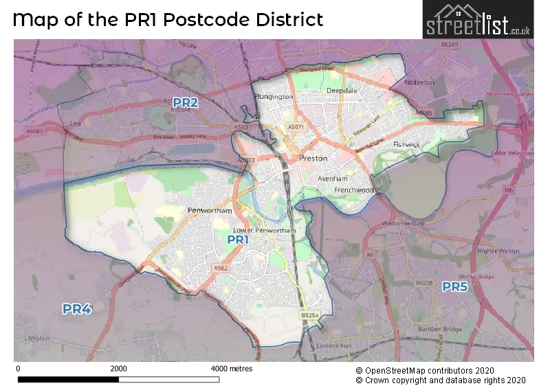
The largest settlements in the PR1 postal code are PRESTON and Penwortham.
The postcode area has a boundary with The Irish Sea.
The PR1 Postcode shares a border with PR5 (Bamber Bridge, Lostock Hall, Walton-le-Dale), PR2 (Fulwood, Ashton-on-Ribble, Ribbleton) and PR4 (Kirkham, Cottam, Freckleton).
The primary settlement in the PR1 postcode district is Preston, located in the county of Lancashire in England. Other significant settlements in this district include Penwortham. The most significant post town in the PR1 postcode district is Preston.
For the district PR1, we have data on 10 postcode sectors. Here's a breakdown: The sector PR1 0, covers Penwortham in Lancashire. The sector PR1 1, covers Preston in Lancashire. The sector PR1 2, covers Preston in Lancashire. The sector PR1 3, covers Preston in Lancashire. The sector PR1 4, covers Preston in Lancashire. The sector PR1 5, covers Preston in Lancashire. The sector PR1 6, covers Preston in Lancashire. The sector PR1 7, covers Preston in Lancashire. The sector PR1 8, covers Preston in Lancashire. The sector PR1 9, covers Penwortham in Lancashire.


Map of the PR1 Postcode District
Explore the PR1 postcode district by using our free interactive map.
When it comes to local government, postal geography often disregards political borders. However, for a breakdown in the PR1 District: the district mostly encompasses the Preston District (B) (1221 postcodes), and finally, the South Ribble District (B) area (456 postcodes).
Recent House Sales in PR1
| Date | Price | Address |
|---|---|---|
| 19/10/2023 | £150,000 | Miller Road, Preston, PR1 5QS |
| 16/10/2023 | £6,793,000 | Fox Street, Preston, PR1 2AB |
| 13/10/2023 | £85,000 | Clara Street, Preston, PR1 4BN |
| 10/10/2023 | £93,000 | Wellington Street, Preston, PR1 8TP |
| 10/10/2023 | £29,000 | Samuel Street, Preston, PR1 4YL |
| 06/10/2023 | £70,000 | Thorn Street, Preston, PR1 5EH |
| 04/10/2023 | £107,000 | River Parade, Preston, PR1 8EJ |
| 29/09/2023 | £100,000 | Lincoln Street, Preston, PR1 6RE |
| 29/09/2023 | £222,500 | Hillside Road, Preston, PR1 4NY |
| 29/09/2023 | £205,000 | The Spinney, Penwortham, Preston, PR1 0NQ |
Weather Forecast for PR1
Press Button to Show Forecast for Preston
| Time Period | Icon | Description | Temperature | Rain Probability | Wind |
|---|---|---|---|---|---|
| 06:00 to 09:00 | Sunny day | 2.0°C (feels like 0.0°C) | 1.00% | ENE 7 mph | |
| 09:00 to 12:00 | Partly cloudy (day) | 7.0°C (feels like 6.0°C) | 5.00% | ENE 4 mph | |
| 12:00 to 15:00 | Cloudy | 9.0°C (feels like 8.0°C) | 6.00% | E 4 mph | |
| 15:00 to 18:00 | Cloudy | 10.0°C (feels like 9.0°C) | 6.00% | ENE 4 mph | |
| 18:00 to 21:00 | Cloudy | 9.0°C (feels like 7.0°C) | 5.00% | NNE 7 mph | |
| 21:00 to 00:00 | Cloudy | 5.0°C (feels like 3.0°C) | 6.00% | NE 7 mph |
Press Button to Show Forecast for Preston
| Time Period | Icon | Description | Temperature | Rain Probability | Wind |
|---|---|---|---|---|---|
| 00:00 to 03:00 | Partly cloudy (night) | 4.0°C (feels like 2.0°C) | 3.00% | E 4 mph | |
| 03:00 to 06:00 | Partly cloudy (night) | 3.0°C (feels like 0.0°C) | 5.00% | E 7 mph | |
| 06:00 to 09:00 | Partly cloudy (day) | 4.0°C (feels like 1.0°C) | 4.00% | ENE 7 mph | |
| 09:00 to 12:00 | Cloudy | 8.0°C (feels like 7.0°C) | 8.00% | E 7 mph | |
| 12:00 to 15:00 | Overcast | 11.0°C (feels like 9.0°C) | 13.00% | E 9 mph | |
| 15:00 to 18:00 | Cloudy | 11.0°C (feels like 9.0°C) | 15.00% | E 7 mph | |
| 18:00 to 21:00 | Cloudy | 10.0°C (feels like 8.0°C) | 15.00% | ENE 9 mph | |
| 21:00 to 00:00 | Partly cloudy (night) | 7.0°C (feels like 5.0°C) | 11.00% | ENE 9 mph |
Press Button to Show Forecast for Preston
| Time Period | Icon | Description | Temperature | Rain Probability | Wind |
|---|---|---|---|---|---|
| 00:00 to 03:00 | Cloudy | 5.0°C (feels like 3.0°C) | 14.00% | NE 9 mph | |
| 03:00 to 06:00 | Cloudy | 5.0°C (feels like 2.0°C) | 15.00% | NNE 7 mph | |
| 06:00 to 09:00 | Cloudy | 6.0°C (feels like 4.0°C) | 20.00% | NNE 7 mph | |
| 09:00 to 12:00 | Cloudy | 8.0°C (feels like 6.0°C) | 21.00% | NE 9 mph | |
| 12:00 to 15:00 | Light rain | 9.0°C (feels like 7.0°C) | 54.00% | NNE 9 mph | |
| 15:00 to 18:00 | Heavy rain | 10.0°C (feels like 8.0°C) | 75.00% | N 9 mph | |
| 18:00 to 21:00 | Light rain shower (day) | 10.0°C (feels like 8.0°C) | 37.00% | NNW 9 mph | |
| 21:00 to 00:00 | Partly cloudy (night) | 7.0°C (feels like 5.0°C) | 12.00% | SSE 7 mph |
Where is the PR1 Postcode District?
The PR1 postcode district is located in PRESTON. It is in close proximity to several nearby towns. To the South, there is LEYLAND, which is approximately 4.62 miles away. To the South East, there is CHORLEY, which is about 7.01 miles away. To the East, there is BLACKBURN, which is around 9.60 miles away. To the West, there is LYTHAM ST. ANNES, which is approximately 11.22 miles away. To the North West, there is POULTON-LE-FYLDE, which is about 12.85 miles away. To the South West, there is SOUTHPORT, which is around 13.33 miles away. The PR1 postcode district is located about 189.49 miles away from the center of London.
The district is within the post town of PRESTON.
The sector has postcodes within the nation of England.
The PR1 Postcode District is in the Mid Lancashire region of Lancashire within the North West (England).
Postcode Sectors within the PR1 District
| Postcode Sector | Delivery Office |
|---|---|
| PR1 0 | Preston Central Delivery Office |
| PR1 1 | Preston Central Delivery Office |
| PR1 2 | Preston Central Delivery Office |
| PR1 3 | Preston Central Delivery Office |
| PR1 4 | Preston Central Delivery Office |
| PR1 5 | Preston Central Delivery Office |
| PR1 6 | Preston Central Delivery Office |
| PR1 7 | Preston Central Delivery Office |
| PR1 8 | Preston Central Delivery Office |
| PR1 9 | Preston Central Delivery Office |
| P | R | 1 | - | X | X | X |
| P | R | 1 | Space | Numeric | Letter | Letter |
Tourist Attractions within the Postcode Area
We found 1 visitor attractions within the PR1 postcode area
| Lancashire Archives |
|---|
| Other |
| View Lancashire Archives on Google Maps |
Current Monthly Rental Prices
| # Bedrooms | Min Price | Max Price | Avg Price |
|---|---|---|---|
| £1 | £862 | £641 | |
| 1 | £320 | £1,750 | £683 |
| 2 | £525 | £2,000 | £1,088 |
| 3 | £442 | £1,955 | £1,209 |
| 4 | £373 | £6,760 | £1,563 |
| 5 | £368 | £2,750 | £1,964 |
| 6 | £373 | £3,900 | £2,360 |
| 7 | £368 | £3,943 | £2,219 |
Current House Prices
| # Bedrooms | Min Price | Max Price | Avg Price |
|---|---|---|---|
| £28,500 | £2,000,000 | £349,854 | |
| 1 | £30,000 | £195,000 | £95,651 |
| 2 | £30,000 | £330,000 | £123,619 |
| 3 | £99,950 | £450,000 | £210,003 |
| 4 | £75,000 | £499,950 | £287,883 |
| 5 | £289,950 | £575,000 | £426,238 |
| 6 | £164,950 | £650,000 | £327,492 |
| 8 | £300,000 | £400,000 | £350,000 |
| 9 | £120,000 | £120,000 | £120,000 |
| 10 | £370,000 | £370,000 | £370,000 |
| 12 | £575,000 | £575,000 | £575,000 |
| 42 | £750,000 | £750,000 | £750,000 |
Estate Agents who Operate in the PR1 District
| Logo | Name | Brand Name | Address | Contact Number | Total Properties |
|---|---|---|---|---|---|
 | Preston | North West Homes | 71 Fylde Road, Preston, PR1 2XQ | 01772 963632 | 231 |
 | Fulwood | Kingswood | 77 Watling Street Road, Fulwood, PR2 8EA | 01772 419788 | 102 |
 | Preston | Jones Cameron Estate Agents | 86 Plungington Road Preston PR1 7RA | 01772 888887 | 40 |
 | covering Preston | Farrell Heyworth | 309 Garstang Road Fulwood Preston PR2 9XJ | 01772 283466 | 33 |
 | Preston | Entwistle Green | 13/14 Chapel Street Preston PR1 8BU | 01772 284722 | 28 |
| Type of Property | 2018 Average | 2018 Sales | 2017 Average | 2017 Sales | 2016 Average | 2016 Sales | 2015 Average | 2015 Sales |
|---|---|---|---|---|---|---|---|---|
| Detached | £257,482 | 116 | £245,889 | 87 | £248,852 | 119 | £234,234 | 137 |
| Semi-Detached | £158,927 | 294 | £159,372 | 291 | £151,448 | 320 | £148,690 | 281 |
| Terraced | £98,366 | 441 | £90,550 | 397 | £91,375 | 406 | £92,461 | 389 |
| Flats | £82,617 | 70 | £72,573 | 120 | £83,700 | 146 | £73,447 | 137 |