The RM14 2 postcode sector stands on the Greater London and Essex border.
Did you know? According to the 2021 Census, the RM14 2 postcode sector is home to a bustling 8,781 residents!
Given that each sector allows for 400 unique postcode combinations. Letters C, I, K, M, O and V are not allowed in the last two letters of a postcode. With 207 postcodes already in use, this leaves 193 units available.
The largest settlements in the RM14 2 postal code are UPMINSTER and HORNCHURCH.
The RM14 2 Postcode shares a border with RM11 3 (HORNCHURCH ), RM12 6 (HORNCHURCH ), RM15 5 (SOUTH OCKENDON ), RM13 9 (RAINHAM ), RM14 1 (UPMINSTER), RM14 3 (UPMINSTER, Bulphan, NORTH OCKENDON) and RM15 4 (AVELEY , PURFLEET ).
The sector is within the post town of UPMINSTER.
RM14 2 is a postcode sector within the RM14 postcode district which is within the RM Romford postcode area.
The Royal Mail delivery office for the RM14 2 postal sector is the Upminster Delivery Office.
The area of the RM14 2 postcode sector is 4.29 square miles which is 11.12 square kilometres or 2,748.13 square acres.
The RM14 2 postcode sector is crossed by the M25 motorway.
Waterways within the RM14 2 postcode sector include the River Ingrebourne.

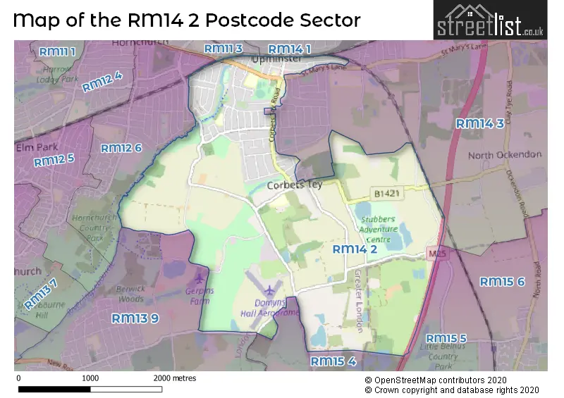
Map of the RM14 2 Postcode Sector
Explore the RM14 2 postcode sector by using our free interactive map.
| R | M | 1 | 4 | - | 2 | X | X |
| R | M | 1 | 4 | Space | 2 | Letter | Letter |
Official List of Streets
UPMINSTER (80 Streets)
Unofficial Streets or Alternative Spellings
UPMINSTER
CRANSTON PARK AVENUE HALL LANE HUNTSMANS DRIVE MEADOW WAY MEADOWSIDE ROAD PARK DRIVENorth Ockendon
OCKENDON ROADHORNCHURCH
GATWICK WAYHORNCHURCH,
HACTON LANE UPMINSTER ROADRAINHAM
WARWICK LANERAINHAM,
BERWICK POND ROADSchools and Places of Education Within the RM14 2 Postcode Sector
Branfil Primary School
Community school
Cedar Avenue, Upminster, Essex, RM14 2LW
Head: Mrs Natalie Sansom
Ofsted Rating: Good
Inspection: 2018-11-15 (2016 days ago)
Website: Visit Branfil Primary School Website
Phone: 01708225186
Number of Pupils: 579
Corbets Tey School
Foundation special school
Harwood Hall Lane, Upminster, Essex, RM14 2YQ
Head: Mrs Emma Allen
Ofsted Rating: Good
Inspection: 2018-03-22 (2254 days ago)
Website: Visit Corbets Tey School Website
Phone: 01708225888
Number of Pupils: 156
Sacred Heart of Mary Girls' School
Academy converter
St Mary's Lane, Upminster, Essex, RM14 2QR
Head: Ms Vivienne Qurrey
Ofsted Rating: Outstanding
Inspection: 2013-11-22 (3835 days ago)
Website: Visit Sacred Heart of Mary Girls' School Website
Phone: 01708222660
Number of Pupils: 834
St Joseph's Catholic Primary School
Voluntary aided school
115 St Mary's Lane, Upminster, Essex, RM14 2QB
Head: Mr Michael Ross
Ofsted Rating: Good
Inspection: 2022-11-02 (568 days ago)
Website: Visit St Joseph's Catholic Primary School Website
Phone: 01708220277
Number of Pupils: 418
House Prices in the RM14 2 Postcode Sector
| Type of Property | 2018 Average | 2018 Sales | 2017 Average | 2017 Sales | 2016 Average | 2016 Sales | 2015 Average | 2015 Sales |
|---|---|---|---|---|---|---|---|---|
| Detached | £696,190 | 21 | £681,250 | 18 | £644,121 | 18 | £611,521 | 19 |
| Semi-Detached | £545,187 | 64 | £518,539 | 65 | £534,419 | 66 | £467,559 | 88 |
| Terraced | £489,861 | 18 | £479,367 | 15 | £416,556 | 9 | £392,615 | 13 |
| Flats | £322,759 | 26 | £354,143 | 28 | £334,518 | 28 | £265,772 | 34 |
Important Postcodes RM14 2 in the Postcode Sector
RM14 2BB is the postcode for London Borough of Havering, Upminster Library, 26 Corbets Tey Road
RM14 2LW is the postcode for KS 2, Branfil Primary School, Cedar Avenue, and Branfil Primary School, Cedar Avenue
RM14 2QB is the postcode for St. Josephs School, 115 St. Marys Lane
RM14 2QR is the postcode for A BLOCK, Sacred Heart of Mary Girls School, St. Marys Lane, F BLOCK, Sacred Heart of Mary Girls School, St. Marys Lane, LIBRARY, Sacred Heart of Mary Girls School, St. Marys Lane, B BLOCK, Sacred Heart of Mary Girls School, St. Marys Lane, SPORTS HALL, Sacred Heart of Mary Girls School, St. Marys Lane, A D & E BLOCKS, Sacred Heart of Mary Girls School, St. Marys Lane, D BLOCK, Sacred Heart of Mary Girls School, St. Marys Lane, and H BLOCK, Sacred Heart of Mary Girls School, St. Marys Lane
RM14 2UB is the postcode for ROOMES FURNITURE STORE, Roomes Stores Ltd, 22-24 Station Road, and Roomes Stores Ltd, 22-24 Station Road
RM14 2UY is the postcode for London Borough of Havering, South Essex Crematorium, Ockendon Road
RM14 2YQ is the postcode for MAIN BUILDING, Corbets Tey School, Harwood Hall Lane, and Corbets Tey School, Harwood Hall Lane
| The RM14 2 Sector is within these Local Authorities |
|
|---|---|
| The RM14 2 Sector is within these Counties |
|
| The RM14 2 Sector is within these Water Company Areas |
|