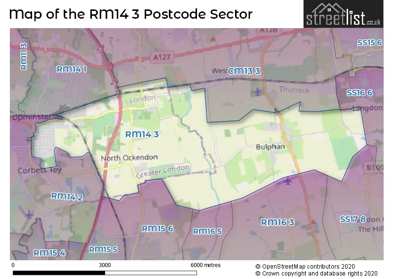
The RM14 3 postcode sector stands on the Essex and Greater London border.
Did you know? According to the 2021 Census, the RM14 3 postcode sector is home to a bustling 7,666 residents!
Given that each sector allows for 400 unique postcode combinations. Letters C, I, K, M, O and V are not allowed in the last two letters of a postcode. With 176 postcodes already in use, this leaves 224 units available.
The largest settlement in the RM14 3 postal code is UPMINSTER followed by Bulphan, and NORTH OCKENDON.
The RM14 3 Postcode shares a border with RM15 5 (SOUTH OCKENDON ), RM16 5 (NORTH STIFFORD, GRAYS, SOUTH OCKENDON), SS16 6 (Langdon Hills, BASILDON), RM14 1 (UPMINSTER), RM14 2 (UPMINSTER, HORNCHURCH), RM15 6 (SOUTH OCKENDON ), RM16 3 (Orsett, CHADWELL ST MARY, NORTH STIFFORD), SS17 8 (STANFORD-LE-HOPE, Horndon-on-the-Hill, Corringham) and CM13 3 (WEST HORNDON, GREAT WARLEY, WARLEY).
The sector is within the post town of UPMINSTER.
RM14 3 is a postcode sector within the RM14 postcode district which is within the RM Romford postcode area.
The Royal Mail delivery office for the RM14 3 postal sector is the Upminster Delivery Office.
The area of the RM14 3 postcode sector is 10.58 square miles which is 27.40 square kilometres or 6,769.63 square acres.
The RM14 3 postcode sector is crossed by the M25 motorway.
Waterways within the RM14 3 postcode sector include the Mardyke.

Map of the RM14 3 Postcode Sector
Explore the RM14 3 postcode sector by using our free interactive map.
| R | M | 1 | 4 | - | 3 | X | X |
| R | M | 1 | 4 | Space | 3 | Letter | Letter |
Official List of Streets
Bulphan (19 Streets)
UPMINSTER (48 Streets)
Unofficial Streets or Alternative Spellings
Little Warley
LITTLE WARLEY HALL LANELangdon Hills
OLD CHURCH HILLUPMINSTER
AYLETT ROAD CORBETS TEY ROAD GARBUTT ROAD HOWARD ROADGreat Warley
WARLEY STREETSchools and Places of Education Within the RM14 3 Postcode Sector
Bulphan Church of England Academy
Academy sponsor led
Fen Lane, Bulphan, Essex, RM14 3RL
Head: Miss Ellie Taylor
Ofsted Rating: Requires improvement
Inspection: 2022-01-26 (848 days ago)
Website: Visit Bulphan Church of England Academy Website
Phone: 01375891220
Number of Pupils: 67
Gaynes School
Academy sponsor led
Brackendale Gardens, Upminster, Essex, RM14 3UX
Head: Annabelle Kirkpatrick
Ofsted Rating: Good
Inspection: 2022-11-30 (540 days ago)
Website: Visit Gaynes School Website
Phone: 01708502900
Number of Pupils: 288
The Coopers' Company and Coborn School
Academy converter
St Mary's Lane, Upminster, Essex, RM14 3HS
Head: Ms Sue Hay
Ofsted Rating: Good
Inspection: 2022-09-22 (609 days ago)
Website: Visit The Coopers' Company and Coborn School Website
Phone: 01708250500
Number of Pupils: 1543
The James Oglethorpe Primary School
Community school
Ashvale Gardens, Upminster, Essex, RM14 3NB
Head: Mrs Hayley Durrant
Ofsted Rating: Good
Inspection: 2023-06-21 (337 days ago)
Website: Visit The James Oglethorpe Primary School Website
Phone: 01708225202
Number of Pupils: 398
Upminster Infant School
Academy converter
St Mary's Lane, Upminster, Essex, RM14 3BS
Head: Helen Lendon
Ofsted Rating: Good
Inspection: 2023-11-16 (189 days ago)
Website: Visit Upminster Infant School Website
Phone: 01708227320
Number of Pupils: 261
Upminster Junior School
Academy converter
, UPMINSTER, Essex, RM14 3BS
Head: Ms Alison Edgcombe
Ofsted Rating: Good
Inspection: 2022-01-27 (847 days ago)
Website: Visit Upminster Junior School Website
Phone: 01708227320
Number of Pupils: 359
House Prices in the RM14 3 Postcode Sector
| Type of Property | 2018 Average | 2018 Sales | 2017 Average | 2017 Sales | 2016 Average | 2016 Sales | 2015 Average | 2015 Sales |
|---|---|---|---|---|---|---|---|---|
| Detached | £802,824 | 17 | £668,260 | 26 | £673,353 | 17 | £613,957 | 21 |
| Semi-Detached | £560,371 | 58 | £542,319 | 59 | £526,304 | 59 | £443,378 | 53 |
| Terraced | £527,458 | 12 | £524,055 | 9 | £517,500 | 5 | £387,000 | 8 |
| Flats | £316,875 | 4 | £281,000 | 6 | £246,405 | 5 | £238,833 | 6 |
Important Postcodes RM14 3 in the Postcode Sector
RM14 3BS is the postcode for BLOCK B, Upminster Junior and Infant School, St. Marys Lane, and BLOCK A, Upminster Junior and Infant School, St. Marys Lane
RM14 3HS is the postcode for MUSIC BUILDING, Coopers Company & Coborn School, St. Marys Lane, MAIN BUILDING, Coopers Company & Coborn School, St. Marys Lane, SIXTH FORM BUILDING, Coopers Company & Coborn School, St. Marys Lane, ART & CDT BUILDING, Coopers Company & Coborn School, St. Marys Lane, SCIENCE BUILDING, Coopers Company & Coborn School, St. Marys Lane, HUMANITIES BUILDING, Coopers Company & Coborn School, St. Marys Lane, and LOWER SCHOOL BUILDING, Coopers Company & Coborn School, St. Marys Lane
RM14 3NB is the postcode for The James Oglethorpe Primary School, Ashvale Gardens
RM14 3RL is the postcode for MAIN BUILDING, Bulphan Primary School, Fen Lane
RM14 3UX is the postcode for MAIN BUILDING (A-C), Gaynes School, Brackendale Gardens, SPORTS BLOCK, Gaynes School, Brackendale Gardens, BLOCK D, Gaynes School, Brackendale Gardens, and Gaynes School, Brackendale Gardens
| The RM14 3 Sector is within these Local Authorities |
|
|---|---|
| The RM14 3 Sector is within these Counties |
|
| The RM14 3 Sector is within these Water Company Areas |
|
Tourist Attractions within the RM14 3 Postcode Area
We found 1 visitor attractions within the RM14 postcode area
| Thames Chase Forest Centre |
|---|
| Country Parks |
| Country Park |
| View Thames Chase Forest Centre on Google Maps |