The S11 7 postcode sector stands on the Derbyshire and South Yorkshire border.
Did you know? According to the 2021 Census, the S11 7 postcode sector is home to a bustling 10,658 residents!
Given that each sector allows for 400 unique postcode combinations. Letters C, I, K, M, O and V are not allowed in the last two letters of a postcode. With 179 postcodes already in use, this leaves 221 units available.
The S11 7 postal code covers the settlement of SHEFFIELD.
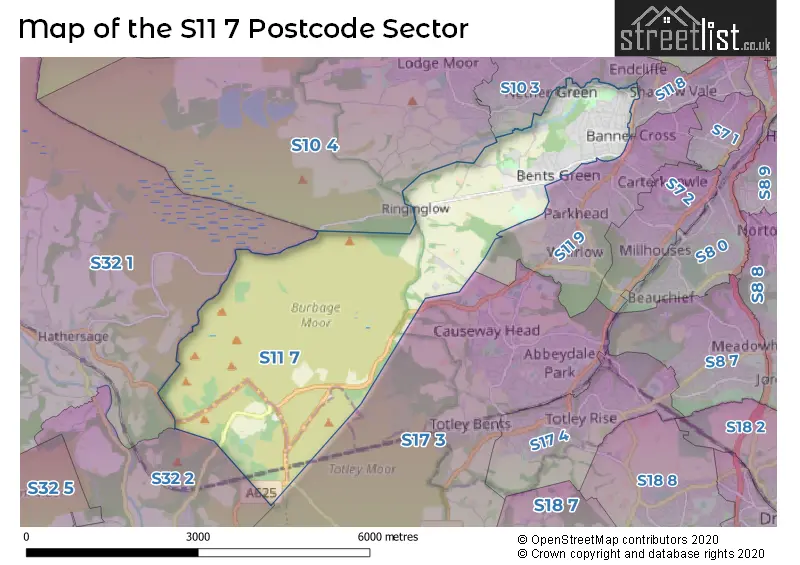
The S11 7 Postcode shares a border with S11 8 (SHEFFIELD), S10 3 (SHEFFIELD), S10 4 (SHEFFIELD), S11 9 (SHEFFIELD), S17 3 (SHEFFIELD, Dore, Totley Rise), S32 1 (Hathersage) and S32 2 (Grindleford).
The sector is within the post town of SHEFFIELD.
S11 7 is a postcode sector within the S11 postcode district which is within the S Sheffield postcode area.
The Royal Mail delivery office for the S11 7 postal sector is the Sheffield Swpostal Delivery Office.
The area of the S11 7 postcode sector is 7.63 square miles which is 19.76 square kilometres or 4,882.71 square acres.
Waterways within the S11 7 postcode sector include the Burbage Brook, Redcar Brook, Porter Brook.

Map of the S11 7 Postcode Sector
Explore the S11 7 postcode sector by using our free interactive map.
| S | 1 | 1 | - | 7 | X | X |
| S | 1 | 1 | Space | 7 | Letter | Letter |
Official List of Streets
SHEFFIELD (86 Streets)
Unofficial Streets or Alternative Spellings
SHEFFIELD
BENTS DRIVE BENTS ROAD BENTS VIEW CLARENDON ROAD ECCLESALL ROAD GRAHAM ROAD HOOBER AVENUE KNOWLE LANE MARSH HOUSE ROAD MOSS ROAD RIVERDALE ROAD WHITELOW LANE BANNER COURT BENTS GREEN PLACE BURBAGE BRIDGE CLARENDON COURT COIT LANE COW LANE DEVILS ELBOW DOBBIN COURT GREYFRIARS GREYSTONES GRANGE HANGING WATER CLOSE HOLLOWGATE JUMBLE ROAD LADY CANNINGS COOKING ON GAS MARMION ROAD OAKBROOK COURT OWLER BAR ROAD PACKHORSE BRIDGE PIPER HOUSE GATE DESCENT PORTER BROOK TRAIL STONY RIDGE ROAD WOOD CLIFFE WRAGBY ROADDore
HATHERSAGE ROADWeather Forecast for S11 7
Press Button to Show Forecast for Dore
| Time Period | Icon | Description | Temperature | Rain Probability | Wind |
|---|---|---|---|---|---|
| 06:00 to 09:00 | Mist | 10.0°C (feels like 8.0°C) | 19.00% | NNW 7 mph | |
| 09:00 to 12:00 | Light rain | 11.0°C (feels like 10.0°C) | 51.00% | NNW 7 mph | |
| 12:00 to 15:00 | Light rain | 13.0°C (feels like 12.0°C) | 59.00% | NW 7 mph | |
| 15:00 to 18:00 | Heavy rain | 13.0°C (feels like 12.0°C) | 74.00% | WNW 9 mph | |
| 18:00 to 21:00 | Light rain | 12.0°C (feels like 11.0°C) | 53.00% | W 9 mph | |
| 21:00 to 00:00 | Heavy rain | 11.0°C (feels like 9.0°C) | 71.00% | W 9 mph |
Press Button to Show Forecast for Dore
| Time Period | Icon | Description | Temperature | Rain Probability | Wind |
|---|---|---|---|---|---|
| 00:00 to 03:00 | Cloudy | 10.0°C (feels like 8.0°C) | 15.00% | WSW 9 mph | |
| 03:00 to 06:00 | Cloudy | 9.0°C (feels like 7.0°C) | 15.00% | WSW 7 mph | |
| 06:00 to 09:00 | Cloudy | 9.0°C (feels like 7.0°C) | 10.00% | SW 9 mph | |
| 09:00 to 12:00 | Cloudy | 11.0°C (feels like 10.0°C) | 7.00% | SW 9 mph | |
| 12:00 to 15:00 | Cloudy | 14.0°C (feels like 12.0°C) | 8.00% | SW 11 mph | |
| 15:00 to 18:00 | Cloudy | 15.0°C (feels like 13.0°C) | 10.00% | SSW 9 mph | |
| 18:00 to 21:00 | Cloudy | 14.0°C (feels like 13.0°C) | 10.00% | SSW 7 mph | |
| 21:00 to 00:00 | Partly cloudy (night) | 11.0°C (feels like 10.0°C) | 8.00% | WSW 4 mph |
Press Button to Show Forecast for Dore
| Time Period | Icon | Description | Temperature | Rain Probability | Wind |
|---|---|---|---|---|---|
| 00:00 to 03:00 | Cloudy | 9.0°C (feels like 9.0°C) | 11.00% | WSW 4 mph | |
| 03:00 to 06:00 | Cloudy | 8.0°C (feels like 7.0°C) | 11.00% | WSW 4 mph | |
| 06:00 to 09:00 | Cloudy | 9.0°C (feels like 9.0°C) | 11.00% | SE 4 mph | |
| 09:00 to 12:00 | Cloudy | 12.0°C (feels like 11.0°C) | 15.00% | SE 7 mph | |
| 12:00 to 15:00 | Cloudy | 14.0°C (feels like 12.0°C) | 14.00% | SE 7 mph | |
| 15:00 to 18:00 | Cloudy | 14.0°C (feels like 13.0°C) | 16.00% | SE 7 mph | |
| 18:00 to 21:00 | Partly cloudy (day) | 13.0°C (feels like 12.0°C) | 12.00% | SE 7 mph | |
| 21:00 to 00:00 | Cloudy | 11.0°C (feels like 10.0°C) | 12.00% | WSW 7 mph |
Schools and Places of Education Within the S11 7 Postcode Sector
Bents Green School
Community special school
Ringinglow Road, Sheffield, South Yorkshire, S11 7TB
Head: Co Headteacher Aileen Hosty Laura Rzepinski
Ofsted Rating: Good
Inspection: 2018-09-25 (2047 days ago)
Website: Visit Bents Green School Website
Phone: 01142363545
Number of Pupils: 302
Ecclesall Primary School
Community school
High Storrs Road, Sheffield, South Yorkshire, S11 7LG
Head: Mrs Emma Hardy
Ofsted Rating: Good
Inspection: 2023-01-19 (470 days ago)
Website: Visit Ecclesall Primary School Website
Phone: 01142663137
Number of Pupils: 620
Greystones Primary School
Community school
Tullibardine Road, Sheffield, South Yorkshire, S11 7GL
Head: Ms Sinead Gaffney
Ofsted Rating: Good
Inspection: 2022-07-06 (667 days ago)
Website: Visit Greystones Primary School Website
Phone: 01142663413
Number of Pupils: 621
High Storrs School
Academy converter
High Storrs Road, Sheffield, South Yorkshire, S11 7LH
Head: Dr Claire Tasker
Ofsted Rating: Good
Inspection: 2022-03-30 (765 days ago)
Website: Visit High Storrs School Website
Phone: 01142670000
Number of Pupils: 1695
House Prices in the S11 7 Postcode Sector
| Type of Property | 2018 Average | 2018 Sales | 2017 Average | 2017 Sales | 2016 Average | 2016 Sales | 2015 Average | 2015 Sales |
|---|---|---|---|---|---|---|---|---|
| Detached | £416,943 | 25 | £384,985 | 17 | £487,131 | 24 | £338,735 | 18 |
| Semi-Detached | £343,207 | 76 | £320,375 | 100 | £305,449 | 56 | £283,244 | 72 |
| Terraced | £258,518 | 73 | £254,480 | 69 | £237,803 | 72 | £226,617 | 90 |
| Flats | £222,536 | 14 | £196,009 | 17 | £178,125 | 12 | £165,719 | 23 |
Important Postcodes S11 7 in the Postcode Sector
S11 7BJ is the postcode for Greystones Medical Centre, 33 Greystones Road
S11 7EJ is the postcode for Nethergreen Surgery, 34-36 Nethergreen Road
S11 7GL is the postcode for Greystones Primary School, Tullibardine Road, GREYSTONES & DOBBIN BUILDING A BLOCKS 1 & 11, Greystones Primary School, Tullibardine Road, and TULLIBARDINE BUILDING B BLOCK 2, Greystones Primary School, Tullibardine Road
S11 7LG is the postcode for Ecclesall Infant School, High Storrs Road
S11 7LH is the postcode for High Storrs School, High Storrs Road
S11 7PQ is the postcode for Ecclesall C of E Junior School, Ringinglow Road
S11 7TB is the postcode for Bents Green Special School, Ringinglow Road, and Bents Green Secondary School, Ringinglow Road
| The S11 7 Sector is within these Local Authorities |
|
|---|---|
| The S11 7 Sector is within these Counties |
|
| The S11 7 Sector is within these Water Company Areas |
|