The S11 9 postcode sector is within the county of South Yorkshire.
Did you know? According to the 2021 Census, the S11 9 postcode sector is home to a bustling 10,495 residents!
Given that each sector allows for 400 unique postcode combinations. Letters C, I, K, M, O and V are not allowed in the last two letters of a postcode. With 228 postcodes already in use, this leaves 172 units available.
The S11 9 postal code covers the settlement of SHEFFIELD.
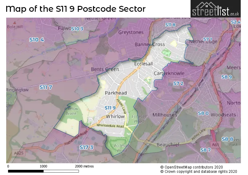
The S11 9 Postcode shares a border with S7 1 (SHEFFIELD), S7 2 (SHEFFIELD), S11 8 (SHEFFIELD), S11 7 (SHEFFIELD) and S17 3 (SHEFFIELD, Dore, Totley Rise).
The sector is within the post town of SHEFFIELD.
S11 9 is a postcode sector within the S11 postcode district which is within the S Sheffield postcode area.
The Royal Mail delivery office for the S11 9 postal sector is the Sheffield Swpostal Delivery Office.
The area of the S11 9 postcode sector is 1.93 square miles which is 5.00 square kilometres or 1,234.90 square acres.

Map of the S11 9 Postcode Sector
Explore the S11 9 postcode sector by using our free interactive map.
| S | 1 | 1 | - | 9 | X | X |
| S | 1 | 1 | Space | 9 | Letter | Letter |
Official List of Streets
SHEFFIELD (133 Streets)
Unofficial Streets or Alternative Spellings
SHEFFIELD
ADELAIDE ROAD ECCLESALL ROAD EDALE ROAD EDGEBROOK ROAD GISBORNE ROAD GLENALMOND ROAD KENWOOD ROAD KNAB ROAD MACHON BANK ROAD MEADOW BANK AVENUE MONTROSE ROAD NETHER EDGE ROAD OAKDALE ROAD OAKHILL ROAD PSALTER LANE RINGINGLOW ROAD SPRINGFIELD AVENUE SPRINGFIELD GLEN SPRINGFIELD ROAD TULLIBARDINE ROAD BARKERS ROAD BROOMSCROFT HOUSE CHARNLEY DRIVE COIT LANE COW LANE EDGEHILL ROAD FENNEY LANE MOORVIEW LANE OSBORNE COURT PARKHEAD COURT RYEFIELDS GARDENS SYCAMORE COURT WOODHOLM PLACEWeather Forecast for S11 9
Press Button to Show Forecast for Parkhead (South Yorkshire)
| Time Period | Icon | Description | Temperature | Rain Probability | Wind |
|---|---|---|---|---|---|
| 15:00 to 18:00 | Cloudy | 8.0°C (feels like 6.0°C) | 30.00% | NE 4 mph | |
| 18:00 to 21:00 | Cloudy | 6.0°C (feels like 4.0°C) | 9.00% | ENE 7 mph | |
| 21:00 to 00:00 | Cloudy | 5.0°C (feels like 3.0°C) | 9.00% | ENE 7 mph |
Press Button to Show Forecast for Parkhead (South Yorkshire)
| Time Period | Icon | Description | Temperature | Rain Probability | Wind |
|---|---|---|---|---|---|
| 00:00 to 03:00 | Cloudy | 4.0°C (feels like 2.0°C) | 4.00% | NE 4 mph | |
| 03:00 to 06:00 | Cloudy | 3.0°C (feels like 1.0°C) | 4.00% | NNE 4 mph | |
| 06:00 to 09:00 | Cloudy | 3.0°C (feels like 1.0°C) | 6.00% | NNE 7 mph | |
| 09:00 to 12:00 | Cloudy | 6.0°C (feels like 3.0°C) | 7.00% | NE 9 mph | |
| 12:00 to 15:00 | Overcast | 8.0°C (feels like 5.0°C) | 22.00% | ENE 9 mph | |
| 15:00 to 18:00 | Overcast | 8.0°C (feels like 5.0°C) | 22.00% | ENE 9 mph | |
| 18:00 to 21:00 | Overcast | 7.0°C (feels like 4.0°C) | 14.00% | ENE 9 mph | |
| 21:00 to 00:00 | Overcast | 6.0°C (feels like 3.0°C) | 11.00% | NE 9 mph |
Press Button to Show Forecast for Parkhead (South Yorkshire)
| Time Period | Icon | Description | Temperature | Rain Probability | Wind |
|---|---|---|---|---|---|
| 00:00 to 03:00 | Cloudy | 5.0°C (feels like 1.0°C) | 6.00% | NNE 9 mph | |
| 03:00 to 06:00 | Cloudy | 4.0°C (feels like 1.0°C) | 52.00% | N 11 mph | |
| 06:00 to 09:00 | Heavy rain | 4.0°C (feels like 0.0°C) | 79.00% | N 13 mph | |
| 09:00 to 12:00 | Heavy rain | 5.0°C (feels like 1.0°C) | 80.00% | NNW 11 mph | |
| 12:00 to 15:00 | Light rain | 7.0°C (feels like 3.0°C) | 46.00% | NNW 11 mph | |
| 15:00 to 18:00 | Cloudy | 9.0°C (feels like 6.0°C) | 13.00% | WNW 11 mph | |
| 18:00 to 21:00 | Partly cloudy (day) | 9.0°C (feels like 6.0°C) | 4.00% | W 9 mph | |
| 21:00 to 00:00 | Clear night | 6.0°C (feels like 3.0°C) | 2.00% | WSW 7 mph |
Press Button to Show Forecast for Parkhead (South Yorkshire)
| Time Period | Icon | Description | Temperature | Rain Probability | Wind |
|---|---|---|---|---|---|
| 00:00 to 03:00 | Clear night | 4.0°C (feels like 2.0°C) | 1.00% | SW 7 mph | |
| 03:00 to 06:00 | Clear night | 3.0°C (feels like 0.0°C) | 1.00% | SW 7 mph | |
| 06:00 to 09:00 | Sunny day | 4.0°C (feels like 1.0°C) | 1.00% | SSW 9 mph | |
| 09:00 to 12:00 | Partly cloudy (day) | 9.0°C (feels like 6.0°C) | 1.00% | S 11 mph | |
| 12:00 to 15:00 | Cloudy | 12.0°C (feels like 9.0°C) | 4.00% | S 13 mph | |
| 15:00 to 18:00 | Overcast | 13.0°C (feels like 10.0°C) | 9.00% | S 13 mph | |
| 18:00 to 21:00 | Sunny day | 12.0°C (feels like 10.0°C) | 3.00% | S 11 mph | |
| 21:00 to 00:00 | Clear night | 9.0°C (feels like 7.0°C) | 2.00% | SSE 9 mph |
Press Button to Show Forecast for Parkhead (South Yorkshire)
| Time Period | Icon | Description | Temperature | Rain Probability | Wind |
|---|---|---|---|---|---|
| 00:00 to 03:00 | Clear night | 7.0°C (feels like 5.0°C) | 2.00% | SSE 9 mph | |
| 03:00 to 06:00 | Partly cloudy (night) | 6.0°C (feels like 4.0°C) | 2.00% | SE 7 mph | |
| 06:00 to 09:00 | Sunny day | 6.0°C (feels like 4.0°C) | 3.00% | ESE 7 mph | |
| 09:00 to 12:00 | Partly cloudy (day) | 10.0°C (feels like 8.0°C) | 5.00% | ESE 9 mph | |
| 12:00 to 15:00 | Cloudy | 13.0°C (feels like 11.0°C) | 8.00% | ESE 11 mph | |
| 15:00 to 18:00 | Cloudy | 15.0°C (feels like 12.0°C) | 19.00% | ESE 11 mph | |
| 18:00 to 21:00 | Cloudy | 13.0°C (feels like 11.0°C) | 8.00% | ESE 9 mph | |
| 21:00 to 00:00 | Cloudy | 11.0°C (feels like 9.0°C) | 10.00% | E 7 mph |
Schools and Places of Education Within the S11 9 Postcode Sector
Silverdale School
Academy converter
Bents Crescent, Sheffield, South Yorkshire, S11 9QH
Head: Mrs Sarah Sims
Ofsted Rating: Good
Inspection: 2022-10-07 (567 days ago)
Website: Visit Silverdale School Website
Phone: 01142369991
Number of Pupils: 1450
House Prices in the S11 9 Postcode Sector
| Type of Property | 2018 Average | 2018 Sales | 2017 Average | 2017 Sales | 2016 Average | 2016 Sales | 2015 Average | 2015 Sales |
|---|---|---|---|---|---|---|---|---|
| Detached | £545,614 | 70 | £497,542 | 79 | £519,994 | 75 | £457,398 | 73 |
| Semi-Detached | £398,890 | 48 | £380,724 | 49 | £364,828 | 41 | £339,569 | 43 |
| Terraced | £413,444 | 9 | £371,625 | 8 | £333,232 | 18 | £365,025 | 25 |
| Flats | £203,830 | 54 | £189,798 | 52 | £194,132 | 53 | £171,384 | 63 |
Important Postcodes S11 9 in the Postcode Sector
S11 9AA is the postcode for Sheffield Childrens NHS Foundation Trust, Shirle Hill Hospital Rcu53
S11 9AL is the postcode for Hollies Medical Centre, 20 St. Andrews Road
S11 9AQ is the postcode for The Kenwood Centre, Clifford Unit, 2 Clifford Road
S11 9AR is the postcode for 9, Williamson Road
S11 9BF is the postcode for Michael Carlisle Centre, 75 Osborne Road, SHEFFIELD ADULT AUTISM & NEURODEVELOPMENTAL SERVICE, Sheffield Health & Social Care NHS Foundation Trust, Michael Carlisle Centre, MICHAEL CARLISLE CENTRE, 75 OSBORNE ROAD, SHEFFIELD, and Sheffield Health & Social Care NHS Foundation Trust, Michael Carlisle Centre
S11 9EF is the postcode for Flockton Community C A M H S, 18 Union Road
S11 9JD is the postcode for Ecclesall Medical Centre, 334 Millhouses Lane
S11 9PL is the postcode for Sheffield City Council, Ecclesall Branch Library, 120 Ecclesall Road South
S11 9QH is the postcode for Silverdale School, Bents Crescent, and SILVERDALE SCHOOL, BENTS CRESCENT, SHEFFIELD
| The S11 9 Sector is within these Local Authorities |
|
|---|---|
| The S11 9 Sector is within these Counties |
|
| The S11 9 Sector is within these Water Company Areas |
|