The S36 6 postcode sector is within the county of South Yorkshire.
Did you know? According to the 2021 Census, the S36 6 postcode sector is home to a bustling 7,019 residents!
Given that each sector allows for 400 unique postcode combinations. Letters C, I, K, M, O and V are not allowed in the last two letters of a postcode. With 151 postcodes already in use, this leaves 249 units available.
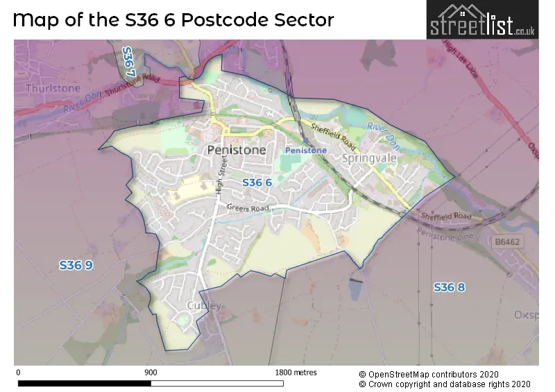
The S36 6 postal code covers the settlement of Penistone.
The S36 6 Postcode shares a border with S36 8 (Oxspring, Penistone, Hoylandswaine), S36 9 (Thurlstone, Millhouse Green, Penistone) and S36 7 (Hoylandswaine, Penistone, Thurlstone).
The sector is within the post town of SHEFFIELD.
S36 6 is a postcode sector within the S36 postcode district which is within the S Sheffield postcode area.
The Royal Mail delivery office for the S36 6 postal sector is the Penistone Scale Payment Delivery Office.
The area of the S36 6 postcode sector is 0.90 square miles which is 2.33 square kilometres or 576.96 square acres.
Waterways within the S36 6 postcode sector include the River Don.


Map of the S36 6 Postcode Sector
Explore the S36 6 postcode sector by using our free interactive map.
| S | 3 | 6 | - | 6 | X | X |
| S | 3 | 6 | Space | 6 | Letter | Letter |
Official List of Streets
Penistone (122 Streets)
Unofficial Streets or Alternative Spellings
Penistone
BRIDGE SIDE CUBLEY WOOD DRIVE FEARNS BUILDINGS HARTCLIFF ROAD HUDDERSFIELD ROAD KIRKHILL BANK LYTTLETON COURT NEW CHAPEL STREET NOOK LANE PENNINE COURT TALBOT ROAD WATER HALL LANE BLACK PATH BOGGARD LANE BOULDER BRIDGE CALLIS LANE COCKPIT LANE CUBLEY RISE ROAD CUBLEY WOOD CLOSE CUBLEY WOOD WAY DON VALLEY TRAIL GARSIDES BUILDINGS HEATHERCLIFFE WAY HINCHLIFF MEWS LONG LANE MARKET GINNEL NEW CHAPEL LANE NEW CHAPEL ROAD PENISTONE BRIDGE REGENT COURT RUD BROOM LANE SCHOLE HILL LANE THE MALTINGS THE OLD VICARAGE VALLEY VIEW WEAVERS COURT WENTWORTH MEWS WEST ACREOxspring
SHEFFIELD ROADHoylandswaine
BARNSLEY ROADSchools and Places of Education Within the S36 6 Postcode Sector
Penistone St John's Voluntary Aided Primary School
Voluntary aided school
High Street, Sheffield, South Yorkshire, S36 6BS
Head: Mrs Susie Arnold
Ofsted Rating: Outstanding
Inspection: 2013-02-27 (4117 days ago)
Website: Visit Penistone St John's Voluntary Aided Primary School Website
Phone: 01226762496
Number of Pupils: 565
Springvale Primary School
Community school
Sheffield Road, Barnsley, South Yorkshire, S36 6HJ
Head: Mr Lee McClure
Ofsted Rating: Good
Inspection: 2023-06-08 (364 days ago)
Website: Visit Springvale Primary School Website
Phone: 01226760930
Number of Pupils: 244
House Prices in the S36 6 Postcode Sector
| Type of Property | 2018 Average | 2018 Sales | 2017 Average | 2017 Sales | 2016 Average | 2016 Sales | 2015 Average | 2015 Sales |
|---|---|---|---|---|---|---|---|---|
| Detached | £270,063 | 43 | £237,556 | 34 | £227,375 | 33 | £240,268 | 30 |
| Semi-Detached | £165,752 | 63 | £163,833 | 46 | £154,855 | 39 | £157,574 | 36 |
| Terraced | £142,217 | 52 | £139,856 | 64 | £145,696 | 59 | £134,226 | 39 |
| Flats | £115,063 | 8 | £94,792 | 12 | £100,439 | 9 | £122,073 | 13 |
Important Postcodes S36 6 in the Postcode Sector
S36 6BR is the postcode for Barnsley Metropolitan Borough Council, Penistone Library, High Street
S36 6BS is the postcode for St. John the Baptist C of E (Aided) Junior School, 82 High Street, ST JOHN THE BAPTIST CHURCH OF ENGLAND JUNIOR SCHOOL, HIGH STREET, PENISTONE, and St. John the Baptist C of E (Aided) Junior School, 82 High Street, Penistone
S36 6BZ is the postcode for Spread Eagle, Market Street
S36 6FS is the postcode for ST JOHN THE BAPTIST CHURCH OF ENGLAND INFANT SCHOOL, CHAPELFIELD LANE, PENISTONE, St. Johns C of E Infant School, Chapel Field Lane, and St. Johns C of E Infant School, Chapel Field Lane, Penistone
S36 6HJ is the postcode for Penistone Springvale Jmi School, Sheffield Road, SPRINGVALE PRIMARY, Penistone Springvale Jmi School, Sheffield Road, and SPRINGVALE PRIMARY SCHOOL, SHEFFIELD ROAD, SPRING VALE
| The S36 6 Sector is within these Local Authorities |
|
|---|---|
| The S36 6 Sector is within these Counties |
|
| The S36 6 Sector is within these Water Company Areas |
|