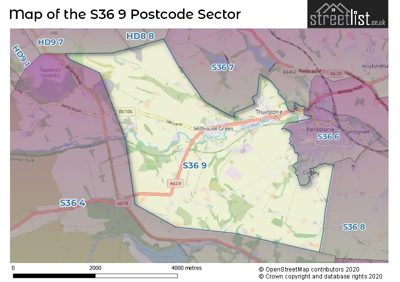
The S36 9 postcode sector is within the county of South Yorkshire.
Did you know? According to the 2021 Census, the S36 9 postcode sector is home to a bustling 3,748 residents!
Given that each sector allows for 400 unique postcode combinations. Letters C, I, K, M, O and V are not allowed in the last two letters of a postcode. With 110 postcodes already in use, this leaves 290 units available.
The largest settlement in the S36 9 postal code is Thurlstone followed by Millhouse Green, and Penistone.
The S36 9 Postcode shares a border with S36 8 (Oxspring, Penistone, Hoylandswaine), S36 4 (Crow Edge, Stocksbridge, Dunford Bridge), S36 6 (Penistone), HD8 8 (Denby Dale, Shepley, Shelley), S36 7 (Hoylandswaine, Penistone, Thurlstone) and HD9 7 (New Mill, Brockholes, Thongsbridge).
The sector is within the post town of SHEFFIELD.
S36 9 is a postcode sector within the S36 postcode district which is within the S Sheffield postcode area.
The Royal Mail delivery office for the S36 9 postal sector is the Penistone Scale Payment Delivery Office.
The area of the S36 9 postcode sector is 6.61 square miles which is 17.13 square kilometres or 4,233.30 square acres.
Waterways within the S36 9 postcode sector include the River Don.

Map of the S36 9 Postcode Sector
Explore the S36 9 postcode sector by using our free interactive map.
| S | 3 | 6 | - | 9 | X | X |
| S | 3 | 6 | Space | 9 | Letter | Letter |
Official List of Streets
Millhouse Green (27 Streets)
Thurlstone (34 Streets)
Penistone (28 Streets)
Unofficial Streets or Alternative Spellings
Penistone
CRANBERRY ROAD FULSHAW LANE MORTIMER DRIVE OLD ANNA LANE OXSPRING ROAD STOTTERCLIFFE ROAD ANNAT ROYD LANE BENT STREET BIRKS COTTAGES BULLHOUSE LANE CALF HEY LANE DOUBTING LANE ECKLANDS LONG LANE FIELD LANE GILBERT HILL HARTCLIFFE LANE HEDGE HILL ROAD HEDGEHILL ROAD HIGH BANK LANE HILL SIDE LANE MYREFIELD PARKIN HOUSE LANE PLUMPTON WAY ROCK SIDE ROAD ROYD FIELD LANE ROYD MOOR HILL ROYDMOOR COURT RUD BROOM LANE SAVILE LANE SCHOLE HILL LANE SIKE LANE SLANT GATE SPICER HOUSE LANE STARLING BRIDGE THE OLD DYE HOUSES WESTFIELD LANE WIND MILL LANEThurlstone
CHAPEL VIEWSchools and Places of Education Within the S36 9 Postcode Sector
Millhouse Primary School
Community school
Lee Lane, Sheffield, South Yorkshire, S36 9LN
Head: Mrs Karen Gray
Ofsted Rating: Good
Inspection: 2023-07-13 (315 days ago)
Website: Visit Millhouse Primary School Website
Phone: 01226763019
Number of Pupils: 122
Thurlstone Primary School
Community school
Royd Moor Road, Sheffield, South Yorkshire, S36 9RD
Head: Mrs Charlotte Gibbins
Ofsted Rating: Good
Inspection: 2023-06-21 (337 days ago)
Website: Visit Thurlstone Primary School Website
Phone: 01226762018
Number of Pupils: 183
House Prices in the S36 9 Postcode Sector
| Type of Property | 2018 Average | 2018 Sales | 2017 Average | 2017 Sales | 2016 Average | 2016 Sales | 2015 Average | 2015 Sales |
|---|---|---|---|---|---|---|---|---|
| Detached | £281,849 | 39 | £254,459 | 55 | £270,821 | 53 | £284,346 | 27 |
| Semi-Detached | £181,975 | 26 | £160,111 | 34 | £149,480 | 34 | £135,733 | 6 |
| Terraced | £175,086 | 11 | £126,876 | 35 | £140,826 | 24 | £152,604 | 14 |
| Flats | £90,500 | 4 | £111,500 | 2 | £0 | 0 | £78,801 | 2 |
Important Postcodes S36 9 in the Postcode Sector
S36 9LN is the postcode for MILLHOUSE PRIMARY SCHOOL, LEE LANE, MILLHOUSE GREEN, and Millhouse School, Lee Lane
S36 9RD is the postcode for Dewers, Old Thurlstone School, Royd Moor Road
| The S36 9 Sector is within these Local Authorities |
|
|---|---|
| The S36 9 Sector is within these Counties |
|
| The S36 9 Sector is within these Water Company Areas |
|