The S72 postcode district is a postal district located in the S Sheffield postcode area with a population of 25,925 residents according to the 2021 England and Wales Census.
The area of the S72 postcode district is 14.98 square miles which is 38.80 square kilometres or 9,588.46 acres.
Currently, the S72 district has about 707 postcode units spread across 4 geographic postcode sectors.
Given that each sector allows for 400 unique postcode combinations, the district has a capacity of 1,600 postcodes. With 707 postcodes already in use, this leaves 893 units available.
The largest settlement in the S72 postal code is Cudworth followed by Grimethorpe, and Shafton.
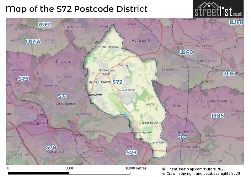
The S72 Postcode shares a border with WF4 (Horbury, Crofton, Crigglestone), WF9 (South Elmsall, Hemsworth, South Kirkby), S73 (Wombwell, Darfield, Brampton), DN5 (DONCASTER, Bentley, Sprotbrough), S63 (Wath-upon-Dearne, Thurnscoe, Goldthorpe) and S71 (BARNSLEY, Royston, Carlton).
The primary settlement in the S72 postcode district is Cudworth, which is located in the county of South Yorkshire, England. Other significant settlements in this district include Grimethorpe and Shafton, also located in South Yorkshire. The most significant post town in the district is Barnsley.
For the district S72, we have data on 4 postcode sectors. Here's a breakdown: The sector S72 0, covers Great Houghton and Little Houghton in South Yorkshire. The sector S72 7, covers Grimethorpe in South Yorkshire. The sector S72 8, covers Cudworth and Shafton in South Yorkshire. The sector S72 9, covers Brierley in South Yorkshire. The sector S72 9, covers South Hiendley in West Yorkshire.

Map of the S72 Postcode District
Explore the S72 postcode district by using our free interactive map.
When it comes to local government, postal geography often disregards political borders. However, for a breakdown in the S72 District: the district mostly encompasses the Barnsley District (B) (646 postcodes), and finally, the Wakefield District (B) area (66 postcodes).
Recent House Sales in S72
| Date | Price | Address |
|---|---|---|
| 18/10/2023 | £138,000 | Clifton Road, Grimethorpe, Barnsley, S72 7EP |
| 17/10/2023 | £212,000 | Shafton Hall Drive, Shafton, Barnsley, S72 8NY |
| 13/10/2023 | £115,000 | Snydale Road, Cudworth, Barnsley, S72 8EX |
| 22/09/2023 | £150,000 | Gilder Way, Shafton, Barnsley, S72 8WP |
| 08/09/2023 | £120,000 | Wood Street, South Hiendley, Barnsley, S72 9AL |
| 08/09/2023 | £197,500 | Burntwood Road, Grimethorpe, Barnsley, S72 7JF |
| 04/09/2023 | £398,000 | Cross Hill, Brierley, Barnsley, S72 9LE |
| 01/09/2023 | £100,000 | Charles Street, Cudworth, Barnsley, S72 8AW |
| 01/09/2023 | £135,000 | Hawthorne Way, Shafton, Barnsley, S72 8PS |
| 01/09/2023 | £280,000 | Willowgarth Drive, Grimethorpe, Barnsley, S72 7FP |
Weather Forecast for S72
Press Button to Show Forecast for Cudworth
| Time Period | Icon | Description | Temperature | Rain Probability | Wind |
|---|---|---|---|---|---|
| 00:00 to 03:00 | Partly cloudy (night) | 3.0°C (feels like 1.0°C) | 1.00% | NNE 2 mph | |
| 03:00 to 06:00 | Partly cloudy (night) | 2.0°C (feels like 0.0°C) | 1.00% | NNW 4 mph | |
| 06:00 to 09:00 | Partly cloudy (day) | 2.0°C (feels like 0.0°C) | 1.00% | NNW 4 mph | |
| 09:00 to 12:00 | Partly cloudy (day) | 6.0°C (feels like 5.0°C) | 37.00% | NE 4 mph | |
| 12:00 to 15:00 | Overcast | 8.0°C (feels like 7.0°C) | 17.00% | NE 4 mph | |
| 15:00 to 18:00 | Cloudy | 9.0°C (feels like 8.0°C) | 10.00% | ENE 4 mph | |
| 18:00 to 21:00 | Cloudy | 7.0°C (feels like 5.0°C) | 10.00% | E 7 mph | |
| 21:00 to 00:00 | Cloudy | 5.0°C (feels like 4.0°C) | 9.00% | NE 4 mph |
Press Button to Show Forecast for Cudworth
| Time Period | Icon | Description | Temperature | Rain Probability | Wind |
|---|---|---|---|---|---|
| 00:00 to 03:00 | Cloudy | 5.0°C (feels like 3.0°C) | 8.00% | NE 4 mph | |
| 03:00 to 06:00 | Partly cloudy (night) | 3.0°C (feels like 1.0°C) | 6.00% | NNE 4 mph | |
| 06:00 to 09:00 | Cloudy | 4.0°C (feels like 2.0°C) | 11.00% | NNE 4 mph | |
| 09:00 to 12:00 | Cloudy | 8.0°C (feels like 6.0°C) | 11.00% | ENE 7 mph | |
| 12:00 to 15:00 | Overcast | 9.0°C (feels like 7.0°C) | 18.00% | ENE 9 mph | |
| 15:00 to 18:00 | Overcast | 10.0°C (feels like 8.0°C) | 20.00% | ENE 9 mph | |
| 18:00 to 21:00 | Cloudy | 9.0°C (feels like 7.0°C) | 18.00% | ENE 9 mph | |
| 21:00 to 00:00 | Cloudy | 7.0°C (feels like 4.0°C) | 16.00% | NE 9 mph |
Press Button to Show Forecast for Cudworth
| Time Period | Icon | Description | Temperature | Rain Probability | Wind |
|---|---|---|---|---|---|
| 00:00 to 03:00 | Cloudy | 6.0°C (feels like 3.0°C) | 22.00% | NNE 9 mph | |
| 03:00 to 06:00 | Light rain | 6.0°C (feels like 3.0°C) | 51.00% | NNE 11 mph | |
| 06:00 to 09:00 | Heavy rain | 7.0°C (feels like 4.0°C) | 77.00% | NNE 11 mph | |
| 09:00 to 12:00 | Heavy rain | 8.0°C (feels like 5.0°C) | 79.00% | NNE 11 mph | |
| 12:00 to 15:00 | Heavy rain | 9.0°C (feels like 7.0°C) | 78.00% | NNE 11 mph | |
| 15:00 to 18:00 | Light rain | 10.0°C (feels like 7.0°C) | 50.00% | NNW 11 mph | |
| 18:00 to 21:00 | Overcast | 9.0°C (feels like 7.0°C) | 19.00% | NW 9 mph | |
| 21:00 to 00:00 | Partly cloudy (night) | 7.0°C (feels like 6.0°C) | 9.00% | SE 7 mph |
Where is the S72 Postcode District?
The postcode district S72 is located in the town of Barnsley. Barnsley is situated near several nearby towns, including Pontefract to the North East (6.31 miles away), Mexborough to the South East (7.00 miles away), Wakefield to the North West (7.95 miles away), Normanton to the North (8.85 miles away), Rotherham to the South (10.23 miles away), and Doncaster to the East (11.42 miles away). Additionally, Barnsley is approximately 152.50 miles away from the center of London.
The district is within the post town of BARNSLEY.
The sector has postcodes within the nation of England.
The S72 Postcode District is covers the following regions.
- Barnsley, Doncaster and Rotherham - South Yorkshire - Yorkshire and The Humber
- Wakefield - West Yorkshire - Yorkshire and The Humber
| Postcode Sector | Delivery Office |
|---|---|
| S72 0 | Barnsley Delivery Office |
| S72 1 | Barnsley Delivery Office |
| S72 2 | Barnsley Delivery Office |
| S72 3 | Barnsley Delivery Office |
| S72 4 | Barnsley Delivery Office |
| S72 5 | Barnsley Delivery Office |
| S72 6 | Barnsley Delivery Office |
| S72 7 | Barnsley Delivery Office |
| S72 7 | Grimethorpe Scale Payment Delivery Office |
| S72 8 | Barnsley Delivery Office |
| S72 8 | Cudworth Scale Payment Delivery Office |
| S72 9 | Barnsley Delivery Office |
| S72 9 | South Hiendley Scale Payment Delivery Office |
| S72 9 | Brierley Scale Payment Delivery Office |
| S | 7 | 2 | - | X | X | X |
| S | 7 | 2 | Space | Numeric | Letter | Letter |
Current Monthly Rental Prices
| # Bedrooms | Min Price | Max Price | Avg Price |
|---|---|---|---|
| 1 | £410 | £750 | £580 |
| 2 | £550 | £650 | £617 |
| 3 | £695 | £900 | £829 |
| 5 | £498 | £498 | £498 |
Current House Prices
| # Bedrooms | Min Price | Max Price | Avg Price |
|---|---|---|---|
| £70,000 | £350,000 | £200,000 | |
| 2 | £60,300 | £285,000 | £130,358 |
| 3 | £60,000 | £795,000 | £197,549 |
| 4 | £125,000 | £1,500,000 | £366,725 |
| 5 | £290,000 | £700,000 | £445,714 |
| 6 | £950,000 | £950,000 | £950,000 |
| 7 | £480,000 | £500,000 | £490,000 |
Estate Agents who Operate in the S72 District
| Logo | Name | Brand Name | Address | Contact Number | Total Properties |
|---|---|---|---|---|---|
 | Barnsley | William H. Brown | 24 Market Hill, Barnsley, S70 2QE | 01226 447524 | 24 |
 | Barnsley | Hunters | 1-3 Church Street Barnsley S70 2AB | 01226 107160 | 15 |
 | Barnsley | NestledIn | The Business Village, BarnsleyBIC, Innovation Way, Barnsley, S75 1JL. | 01226 448844 | 12 |
 | Pontefract | Kestrel Estates | Langthwaite House Langthwaite Road, South Kirkby, WF9 3AE | 01977 803515 | 9 |
 | Yorkshire | Strike | Nationwide | 0113 519 9126 | 8 |
| Type of Property | 2018 Average | 2018 Sales | 2017 Average | 2017 Sales | 2016 Average | 2016 Sales | 2015 Average | 2015 Sales |
|---|---|---|---|---|---|---|---|---|
| Detached | £196,944 | 95 | £197,399 | 87 | £184,556 | 83 | £155,755 | 71 |
| Semi-Detached | £112,111 | 167 | £111,085 | 140 | £97,543 | 127 | £96,910 | 168 |
| Terraced | £83,163 | 133 | £86,922 | 153 | £80,481 | 132 | £82,041 | 106 |
| Flats | £55,890 | 5 | £82,600 | 5 | £66,796 | 11 | £55,683 | 6 |