The SG18 0 postcode sector is within the county of Bedfordshire.
Did you know? According to the 2021 Census, the SG18 0 postcode sector is home to a bustling 9,491 residents!
Given that each sector allows for 400 unique postcode combinations. Letters C, I, K, M, O and V are not allowed in the last two letters of a postcode. With 196 postcodes already in use, this leaves 204 units available.
The SG18 0 postal code covers the settlement of BIGGLESWADE.
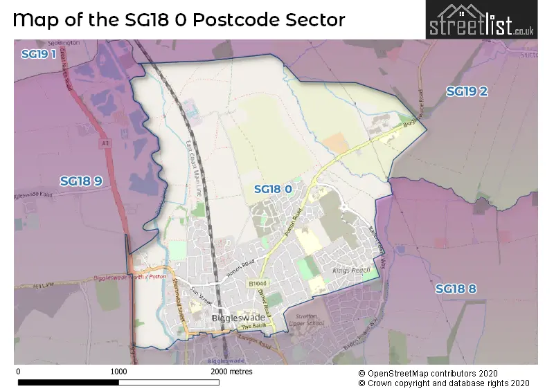
The SG18 0 Postcode shares a border with SG18 8 (BIGGLESWADE, Dunton, Stratton Business Park), SG18 9 (Langford, Upper Caldecote, Broom), SG19 1 (SANDY, Beeston, Hatch) and SG19 2 (Potton, SANDY, Wrestlingworth).
The sector is within the post town of BIGGLESWADE.
SG18 0 is a postcode sector within the SG18 postcode district which is within the SG Stevenage postcode area.
The Royal Mail delivery office for the SG18 0 postal sector is the Biggleswade Delivery Office.
The area of the SG18 0 postcode sector is 2.35 square miles which is 6.09 square kilometres or 1,504.43 square acres.
The SG18 0 postcode sector is crossed by the A1 Major A road.
Waterways within the SG18 0 postcode sector include the River Ivel.

Map of the SG18 0 Postcode Sector
Explore the SG18 0 postcode sector by using our free interactive map.
| S | G | 1 | 8 | - | 0 | X | X |
| S | G | 1 | 8 | Space | 0 | Letter | Letter |
Official List of Streets
BIGGLESWADE (111 Streets)
Unofficial Streets or Alternative Spellings
BIGGLESWADE
ASTON CROFT DILLEY CROFT ERLENSEE WAY HAWKING DRIVE HERSCHEL GREEN HITCHIN STREET LONDON ROAD MARKET SQUARE MAUNDER AVENUE STATION ROAD WALTON GROVE WILLIAMS COURT ABBOTS WALK ARNOLD RISE ASH ROAD BADEN-POWELL WAY BANTOCK WAY BIGGLESWADE BYPASS BIGGLESWADE NORTH ROUNDABOUT BLACKBURN WAY BOSE AVENUE CAMPION GROVE CHAMBERLAIN PARK CHURCHILL COURT COATES ROAD COMPTON MEAD CRICK ROAD CROWN YARD DAVIES CROFT DELIUS ROAD DERING CORNER DEVON ROAD DILLY CROFT ELLICOTT GROVE ELPHICK COURT EVANS GROVE FAIR HOLME FINZI GROVE FRANKEL WAY GIBBENS CROFT HANDEL WAY HOLBROOK GROVE HUNT ROAD KINGFISHER WAY LABURNAM ROAD LONG TWITCHELL LUDFORD LANE LYNTON EDGE MACMILLAN GROVE MASKIN DRIVE MILLERS COURT MITCHELL GREEN NEWTOWN COURT NOVELLO DRIVE PARKLAND PLACE PARRY RISE POPLE ROAD RAILWAY VIEW SAND LANE SHERRINGTON GROVE SHUTTLEWORTH COURT SIMPSON LANE SMYTH VIEW SOMERVILLE CROFT ST ANDREWS STREET SULLIVAN COURT TALLIS LANE TATE DRIVE TAVENER DRIVE TAVISTOCK GREEN THE CLOSE TRINITY CLOSE VICTORIA PLACE WALKER MEAD WELLS COURT WILSON CLOSE WISEMAN ROADOld Warden
HILL LANEPotton
BIGGLESWADE ROADWeather Forecast for SG18 0
Press Button to Show Forecast for Biggleswade
| Time Period | Icon | Description | Temperature | Rain Probability | Wind |
|---|---|---|---|---|---|
| 09:00 to 12:00 | Light rain | 8.0°C (feels like 6.0°C) | 55.00% | WNW 11 mph | |
| 12:00 to 15:00 | Overcast | 7.0°C (feels like 3.0°C) | 56.00% | WNW 16 mph | |
| 15:00 to 18:00 | Cloudy | 9.0°C (feels like 6.0°C) | 48.00% | W 11 mph | |
| 18:00 to 21:00 | Cloudy | 10.0°C (feels like 8.0°C) | 7.00% | SW 9 mph | |
| 21:00 to 00:00 | Clear night | 8.0°C (feels like 5.0°C) | 1.00% | SSW 9 mph |
Press Button to Show Forecast for Biggleswade
| Time Period | Icon | Description | Temperature | Rain Probability | Wind |
|---|---|---|---|---|---|
| 00:00 to 03:00 | Clear night | 6.0°C (feels like 3.0°C) | 1.00% | SW 9 mph | |
| 03:00 to 06:00 | Clear night | 5.0°C (feels like 2.0°C) | 0.00% | S 7 mph | |
| 06:00 to 09:00 | Sunny day | 6.0°C (feels like 3.0°C) | 0.00% | S 9 mph | |
| 09:00 to 12:00 | Partly cloudy (day) | 12.0°C (feels like 9.0°C) | 1.00% | SSW 13 mph | |
| 12:00 to 15:00 | Cloudy | 14.0°C (feels like 11.0°C) | 5.00% | S 16 mph | |
| 15:00 to 18:00 | Cloudy | 15.0°C (feels like 11.0°C) | 5.00% | SSW 16 mph | |
| 18:00 to 21:00 | Sunny day | 13.0°C (feels like 11.0°C) | 0.00% | S 11 mph | |
| 21:00 to 00:00 | Clear night | 9.0°C (feels like 7.0°C) | 1.00% | SSE 9 mph |
Press Button to Show Forecast for Biggleswade
| Time Period | Icon | Description | Temperature | Rain Probability | Wind |
|---|---|---|---|---|---|
| 00:00 to 03:00 | Clear night | 8.0°C (feels like 6.0°C) | 1.00% | SE 9 mph | |
| 03:00 to 06:00 | Clear night | 7.0°C (feels like 5.0°C) | 1.00% | SE 9 mph | |
| 06:00 to 09:00 | Sunny day | 9.0°C (feels like 7.0°C) | 1.00% | SE 9 mph | |
| 09:00 to 12:00 | Cloudy | 14.0°C (feels like 12.0°C) | 7.00% | SE 9 mph | |
| 12:00 to 15:00 | Light rain shower (day) | 16.0°C (feels like 13.0°C) | 31.00% | SE 11 mph | |
| 15:00 to 18:00 | Cloudy | 16.0°C (feels like 14.0°C) | 9.00% | SSE 11 mph | |
| 18:00 to 21:00 | Cloudy | 15.0°C (feels like 13.0°C) | 10.00% | SE 9 mph | |
| 21:00 to 00:00 | Cloudy | 12.0°C (feels like 11.0°C) | 14.00% | SE 7 mph |
Press Button to Show Forecast for Biggleswade
| Time Period | Icon | Description | Temperature | Rain Probability | Wind |
|---|---|---|---|---|---|
| 00:00 to 03:00 | Cloudy | 11.0°C (feels like 10.0°C) | 17.00% | SE 4 mph | |
| 03:00 to 06:00 | Cloudy | 10.0°C (feels like 9.0°C) | 17.00% | ESE 4 mph | |
| 06:00 to 09:00 | Mist | 10.0°C (feels like 10.0°C) | 22.00% | ESE 2 mph | |
| 09:00 to 12:00 | Cloudy | 14.0°C (feels like 13.0°C) | 11.00% | E 7 mph | |
| 12:00 to 15:00 | Cloudy | 17.0°C (feels like 16.0°C) | 18.00% | E 7 mph | |
| 15:00 to 18:00 | Cloudy | 18.0°C (feels like 17.0°C) | 15.00% | NE 7 mph | |
| 18:00 to 21:00 | Cloudy | 15.0°C (feels like 15.0°C) | 13.00% | ESE 7 mph | |
| 21:00 to 00:00 | Light rain shower (night) | 13.0°C (feels like 12.0°C) | 29.00% | NE 7 mph |
Schools and Places of Education Within the SG18 0 Postcode Sector
Edward Peake CofE VC Middle School
Voluntary controlled school
Potton Road, Biggleswade, Bedfordshire, SG18 0EJ
Head: Miss Z J Linington
Ofsted Rating: Requires improvement
Inspection: 2022-05-25 (704 days ago)
Website: Visit Edward Peake CofE VC Middle School Website
Phone: 01767314562
Number of Pupils: 548
Ivel Valley School & College
Community special school
Hitchmead Road, Biggleswade, Bedfordshire, SG18 0NL
Head: Mr Joe Creswick
Ofsted Rating: Good
Inspection: 2023-09-20 (221 days ago)
Website: Visit Ivel Valley School & College Website
Phone: 01767601010
Number of Pupils: 243
Lawnside Academy
Academy converter
Lawnside, Biggleswade, Bedfordshire, SG18 0LX
Head: Headteacher Cheryl Johnson
Ofsted Rating: Good
Inspection: 2023-03-29 (396 days ago)
Website: Visit Lawnside Academy Website
Phone: 01767312313
Number of Pupils: 171
St Andrew's CofE VC Lower School
Voluntary controlled school
Brunts Lane, Biggleswade, Bedfordshire, SG18 0LY
Head: Mrs Sue Rolfe
Ofsted Rating: Good
Inspection: 2021-11-19 (891 days ago)
Website: Visit St Andrew's CofE VC Lower School Website
Phone: 01767312311
Number of Pupils: 792
House Prices in the SG18 0 Postcode Sector
| Type of Property | 2018 Average | 2018 Sales | 2017 Average | 2017 Sales | 2016 Average | 2016 Sales | 2015 Average | 2015 Sales |
|---|---|---|---|---|---|---|---|---|
| Detached | £456,187 | 45 | £465,019 | 74 | £389,044 | 73 | £298,145 | 24 |
| Semi-Detached | £310,875 | 54 | £303,504 | 71 | £278,407 | 72 | £241,545 | 42 |
| Terraced | £257,405 | 53 | £264,544 | 64 | £239,781 | 64 | £202,291 | 60 |
| Flats | £244,378 | 93 | £166,297 | 34 | £162,483 | 39 | £139,192 | 33 |
Important Postcodes SG18 0 in the Postcode Sector
SG18 0EJ is the postcode for Edward Peake School, Potton Road
SG18 0EL is the postcode for HALSEY WARD, Biggleswade Hospital, Potton Road, WHITBREAD/LINDSALL WARD, Biggleswade Hospital, Potton Road, SPRING HOUSE, Biggleswade Hospital, Potton Road, and Bedfordshire PCT, Biggleswade Hospital
SG18 0JH is the postcode for 73 High Street
SG18 0LL is the postcode for Biggleswade Library, Chestnut Avenue, and Bedfordshire County Council, Fire Station, Chestnut Avenue
SG18 0LX is the postcode for Lawnside Lower School, Lawnside
SG18 0LY is the postcode for St. Andrews School, Brunts Lane, and St Andrews VC Lower School, Brunts Lane
SG18 0NL is the postcode for Ivel Valley School, Hitchmead Road, Biggleswade, and Ivel Valley School, Hitchmead Road
SG18 0PT is the postcode for The Lawns Nursery School & Childrens Centre, The Baulk, Maythorn Care Home, The Baulk, and Ivel Valley School, The Baulk
SG18 0RA is the postcode for Ivel Medical Centre, Chestnut Avenue
| The SG18 0 Sector is within these Local Authorities |
|
|---|---|
| The SG18 0 Sector is within these Counties |
|
| The SG18 0 Sector is within these Water Company Areas |
|