The SL3 0 postcode sector lies where the four counties of Berkshire, Buckinghamshire, Greater London, and Surrey meet.
Did you know? According to the 2021 Census, the SL3 0 postcode sector is home to a bustling 3,941 residents!
Given that each sector allows for 400 unique postcode combinations. Letters C, I, K, M, O and V are not allowed in the last two letters of a postcode. With 164 postcodes already in use, this leaves 236 units available.
The largest settlements in the SL3 0 postal code are POYLE and COLNBROOK.
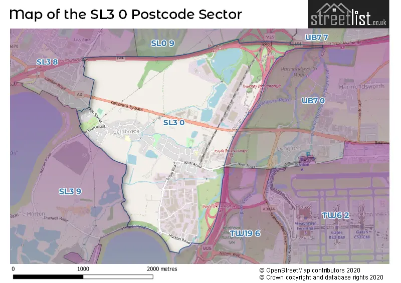
The SL3 0 Postcode shares a border with SL0 9 (IVER ), SL3 8 (SLOUGH, LANGLEY), SL3 9 (Datchet, HORTON), TW19 6 (STANWELL MOOR, STAINES-UPON-THAMES, WRAYSBURY), UB7 0 (WEST DRAYTON , LONGFORD , SIPSON ) and UB7 7 (WEST DRAYTON , YIEWSLEY ).
The sector is within the post town of SLOUGH.
SL3 0 is a postcode sector within the SL3 postcode district which is within the SL Slough postcode area.
The Royal Mail delivery office for the SL3 0 postal sector is the Slough Delivery Office.
The area of the SL3 0 postcode sector is 2.02 square miles which is 5.22 square kilometres or 1,291.01 square acres.
The SL3 0 postcode sector is crossed by the M4 motorway.
The SL3 0 postcode sector is crossed by the M25 motorway.
Waterways within the SL3 0 postcode sector include the Wraysbury River, Duke of Northumberland's River.

Map of the SL3 0 Postcode Sector
Explore the SL3 0 postcode sector by using our free interactive map.
| S | L | 3 | - | 0 | X | X |
| S | L | 3 | Space | 0 | Letter | Letter |
Official List of Streets
Colnbrook (59 Streets)
SLOUGH (1 Streets)
Unofficial Streets or Alternative Spellings
Schools and Places of Education Within the SL3 0 Postcode Sector
Colnbrook Church of England Primary School
Academy sponsor led
High Street, Colnbrook, Berkshire, SL3 0JZ
Head: Mr Tom Brunson
Ofsted Rating: Good
Inspection: 2018-11-08 (2023 days ago)
Website: Visit Colnbrook Church of England Primary School Website
Phone: 01753683661
Number of Pupils: 223
Pippins School
Foundation school
Raymond Close, Colnbrook, Berkshire, SL3 0PR
Head: Mr Maninder Jalaf
Ofsted Rating: Good
Inspection: 2022-09-14 (617 days ago)
Website: Visit Pippins School Website
Phone: 01753682937
Number of Pupils: 200
House Prices in the SL3 0 Postcode Sector
| Type of Property | 2018 Average | 2018 Sales | 2017 Average | 2017 Sales | 2016 Average | 2016 Sales | 2015 Average | 2015 Sales |
|---|---|---|---|---|---|---|---|---|
| Detached | £0 | 0 | £0 | 0 | £398,500 | 2 | £0 | 0 |
| Semi-Detached | £340,286 | 14 | £401,342 | 13 | £357,025 | 14 | £347,500 | 12 |
| Terraced | £274,600 | 10 | £298,306 | 24 | £315,826 | 17 | £248,869 | 27 |
| Flats | £222,334 | 25 | £215,962 | 13 | £177,621 | 12 | £179,369 | 24 |
Important Postcodes SL3 0 in the Postcode Sector
SL3 0JZ is the postcode for MAIN BUILDING, Colnbrook C of E Primary School, High Street, Colnbrook C of E Primary School, High Street, LIBRARY BUILDING, Colnbrook C of E Primary School, High Street, and ANNEX BUILDING, Colnbrook C of E Primary School, High Street
SL3 0PR is the postcode for A BLOCK, Pippins School, Raymond Close
| The SL3 0 Sector is within these Local Authorities |
|
|---|---|
| The SL3 0 Sector is within these Counties |
|
| The SL3 0 Sector is within these Water Company Areas |
|