The SN26 8 postcode sector is within the county of Wiltshire.
Did you know? According to the 2021 Census, the SN26 8 postcode sector is home to a bustling 642 residents!
Given that each sector allows for 400 unique postcode combinations. Letters C, I, K, M, O and V are not allowed in the last two letters of a postcode. With 20 postcodes already in use, this leaves 380 units available.
The SN26 8 postal code covers the settlement of Blunsdon.
The SN26 8 Postcode shares a border with SN5 4 (Purton, Purton Stoke), SN6 6 (Cricklade, Ashton Keynes, Leigh), SN6 7 (Highworth, Hannington, Coleshill), SN25 4 (SWINDON), SN26 7 (Blunsdon) and SN25 2 (SWINDON, Tadpole Garden Village, Blunsdon).
The sector is within the post town of SWINDON.
SN26 8 is a postcode sector within the SN2 postcode district which is within the SN Swindon postcode area.
The Royal Mail delivery office for the SN26 8 postal sector is the Hawksworth Delivery Office and Delivery Officercan Postal Delivery Office.
The area of the SN26 8 postcode sector is 3.32 square miles which is 8.61 square kilometres or 2,127.23 square acres.
The SN26 8 postcode sector is crossed by the A419 Major A road.
Waterways within the SN26 8 postcode sector include the River Ray.

Map of the SN26 8 Postcode Sector
Explore the SN26 8 postcode sector by using our free interactive map.
| S | N | 2 | 6 | - | 8 | X | X |
| S | N | 2 | 6 | Space | 8 | Letter | Letter |
Official List of Streets
Blunsdon (14 Streets)
Unofficial Streets or Alternative Spellings
Blunsdon
FORTUNA ROAD HIGH STREET LADY LANE SKYLARK TURNPIKE ROAD ANVIL STREET ARMFIELD ROAD BACK LANE BALLIE CLOSE BARNSLEY CLOSE BAYES CLOSE BLACKWELL CLOSE BLANCHARD ROAD CHAPEL HILL LANE CHERWELL CHURN CLOSE COOPER CLOSE DANEWAY DEARLE ROAD DRESSER CLOSE FARRIER STREET FAULKNER ROAD FRONT LANE GREAT ROSE LANE HANKER CLOSE HEYGATE HIGH GROUND HORTA CLOSE ILETT CRESCENT IMAGE ROAD IRVINE CLOSE JEKYLL CLOSE KEMPE LANE KEOHLER CLOSE KINSLEY CLOSE LALIQUE CLOSE LOWER WIDHILL FARM LANE LUMB CLOSE MATHEWS CLOSE MERCER CLOSE MUCHA CLOSE NEWILL CLOSE PARSONS PLACE PUGIN CLOSE RAY LANE ROBINSCROFT RODMARTON CLOSE SAPPHIRE ROAD SEXTON CLOSE SHAPLAND SHERRER LANE SMITHY CLOSE SOUTH MEADOW LANE STEINLEN CLOSE STICKLEY CLOSE STONEYWELL STONYWELL TADPOLE FARM ROAD THE LEASOWES TIFFANY CLOSE VAN ERP CLOSE WELBY CLOSE WHALL CLOSE WIDHILL LANESWINDON
EMERALD CRESCENT RUBY CLOSETadpole Garden Village
AUGUSTUS CLOSE BAILLIE CLOSE CHATFIELD EASTLAKE GIMSON CRESCENT HORNE CLOSE JEFFREY CLOSE MACKAY CRESCENT MACKMURDO AVENUE NEWLYN CLOSE PEARSON ROAD SCOTT CLOSE SELWYN ROAD WILLIAM MORRIS WAY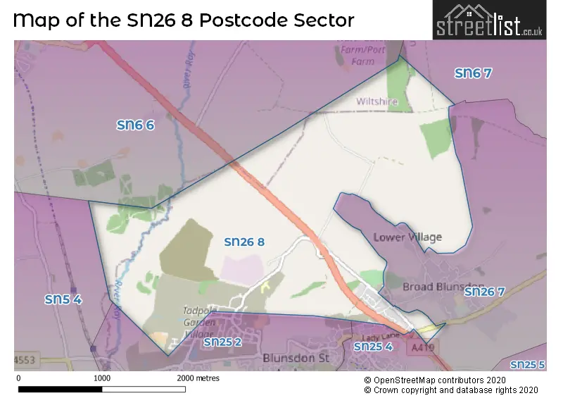
House Prices in the SN26 8 Postcode Sector
| Type of Property | 2018 Average | 2018 Sales | 2017 Average | 2017 Sales | 2016 Average | 2016 Sales | 2015 Average | 2015 Sales |
|---|---|---|---|---|---|---|---|---|
| Detached | £386,000 | 31 | £389,299 | 38 | £388,700 | 5 | £465,000 | 1 |
| Semi-Detached | £235,000 | 2 | £237,175 | 8 | £195,000 | 2 | £202,000 | 1 |
| Terraced | £0 | 0 | £198,283 | 3 | £0 | 0 | £0 | 0 |
| Flats | £0 | 0 | £0 | 0 | £0 | 0 | £0 | 0 |
| The SN26 8 Sector is within these Local Authorities |
|
|---|---|
| The SN26 8 Sector is within these Counties |
|
| The SN26 8 Sector is within these Water Company Areas |
|