The SY3 5 postcode sector is within the county of Shropshire.
Did you know? According to the 2021 Census, the SY3 5 postcode sector is home to a bustling 4,612 residents!
Given that each sector allows for 400 unique postcode combinations. Letters C, I, K, M, O and V are not allowed in the last two letters of a postcode. With 139 postcodes already in use, this leaves 261 units available.
The largest settlement in the SY3 5 postal code is Bicton Heath followed by SHREWSBURY, and Bowbrook.
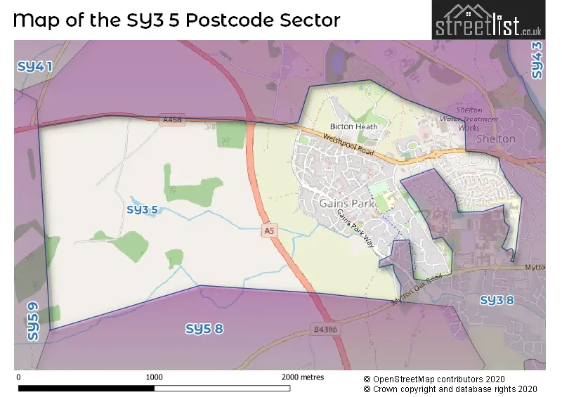
The SY3 5 Postcode shares a border with SY5 8 (Hanwood, Bowbrook, Longden), SY3 8 (SHREWSBURY, Bicton, Bicton Heath) and SY5 9 (Westbury, Ford, Halfway House).
The sector is within the post town of SHREWSBURY.
SY3 5 is a postcode sector within the SY3 postcode district which is within the SY Shrewsbury postcode area.
The Royal Mail delivery office for the SY3 5 postal sector is the Shrewsbury Delivery Office.
The area of the SY3 5 postcode sector is 1.62 square miles which is 4.20 square kilometres or 1,037.08 square acres.

Map of the SY3 5 Postcode Sector
Explore the SY3 5 postcode sector by using our free interactive map.
| S | Y | 3 | - | 5 | X | X |
| S | Y | 3 | Space | 5 | Letter | Letter |
Official List of Streets
Bicton Heath (87 Streets)
Bowbrook (4 Streets)
SHREWSBURY (10 Streets)
Bicton (1 Streets)
Unofficial Streets or Alternative Spellings
Bicton Heath
CLAYTON WAY PENSFOLD COURT SOMERBY DRIVESHREWSBURY
HURSTEAD COURT SANDOWN CRESCENT SHACKLETON WAYBowbrook
HARPERS MEADOW MYTTON OAK ROAD BADGERS WAY BOWBROOK GARDENS CASSELS WAY DARWIN COURT HOLSWORTH PARK LITTLE OXON LANE THE COPSE THE OAKLANDS THEORCHARD WESTSIDE DRIVE WINGFIELD ROAD WORROW CLOSE YEWBREY CLOSESchools and Places of Education Within the SY3 5 Postcode Sector
Oxon CofE Primary School
Voluntary controlled school
Racecourse Lane, Shrewsbury, Shropshire, SY3 5BJ
Head: Mr Mark Rogers
Ofsted Rating: Outstanding
Inspection: 2023-06-07 (362 days ago)
Website: Visit Oxon CofE Primary School Website
Phone: 01743351948
Number of Pupils: 427
House Prices in the SY3 5 Postcode Sector
| Type of Property | 2018 Average | 2018 Sales | 2017 Average | 2017 Sales | 2016 Average | 2016 Sales | 2015 Average | 2015 Sales |
|---|---|---|---|---|---|---|---|---|
| Detached | £308,401 | 61 | £312,094 | 39 | £304,943 | 58 | £261,578 | 40 |
| Semi-Detached | £184,234 | 22 | £170,116 | 28 | £160,467 | 27 | £162,416 | 19 |
| Terraced | £141,503 | 39 | £140,845 | 42 | £122,901 | 37 | £113,870 | 23 |
| Flats | £165,743 | 42 | £176,164 | 32 | £175,438 | 26 | £44,857 | 7 |
Important Postcodes SY3 5 in the Postcode Sector
SY3 5BJ is the postcode for Oxon C of E Primary School, Racecourse Lane, and Oxon C of E Primary School, Racecourse Lane, Bicton Heath
SY3 5HJ is the postcode for HM Revenue & Customs, New Mayfield House, Holsworth Park, Oxon Business Park, H M Customs & Excise, New Mayfield House, Oxon Business Park, Holsworth Park, and West Mercia Supplies, Holsworth Park, Oxon Business Park
SY3 5LZ is the postcode for Mytton Oak Medical Practice, Racecourse Lane
| The SY3 5 Sector is within these Local Authorities |
|
|---|---|
| The SY3 5 Sector is within these Counties |
|
| The SY3 5 Sector is within these Water Company Areas |
|