The SY3 7 postcode sector is within the county of Shropshire.
Did you know? According to the 2021 Census, the SY3 7 postcode sector is home to a bustling 7,174 residents!
Given that each sector allows for 400 unique postcode combinations. Letters C, I, K, M, O and V are not allowed in the last two letters of a postcode. With 225 postcodes already in use, this leaves 175 units available.
The SY3 7 postal code covers the settlement of SHREWSBURY.
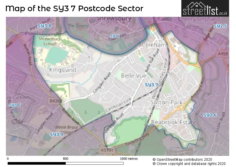
The SY3 7 Postcode shares a border with SY1 1 (SHREWSBURY), SY2 6 (SHREWSBURY), SY3 8 (SHREWSBURY, Bicton, Bicton Heath) and SY3 9 (SHREWSBURY, Meole Brace).
The sector is within the post town of SHREWSBURY.
SY3 7 is a postcode sector within the SY3 postcode district which is within the SY Shrewsbury postcode area.
The Royal Mail delivery office for the SY3 7 postal sector is the Shrewsbury Delivery Office.
The area of the SY3 7 postcode sector is 1.00 square miles which is 2.59 square kilometres or 640.66 square acres.

Map of the SY3 7 Postcode Sector
Explore the SY3 7 postcode sector by using our free interactive map.
| S | Y | 3 | - | 7 | X | X |
| S | Y | 3 | Space | 7 | Letter | Letter |
Official List of Streets
SHREWSBURY (95 Streets)
Kingsland (1 Streets)
Unofficial Streets or Alternative Spellings
SHREWSBURY
ABBEY FOREGATE ALMS COURT BESFORD GARDENS LONGDEN GROVE MEOLE RISE OAKLEY MANOR GARDENS OLD ROMAN ROAD ROMAN ROAD THE OLD MEADOW UPPER ROAD ALTON TERRACE BACK LIME STREET BAGE WAY BROOK GARDENS BROUGHAM SQUARE COLEHAM ROW EGLAND LANE ENGLISH BRIDGE ENGLISH BRIDGE GYRATORY GOATLANDS GREYFRIARS BRIDGE HAZLEDINE WAY KINGSLAND BRIDGE KINGSLAND COTTAGES LIME TERRACE LINDEN GARDENS LORNE TERRACE MANSELL WILLIAMS WAY MORETON COTTAGES POUND CLOSE POUNTNEY GARDENS PRITCHARD WAY REABROOK ROUNDABOUT RIVERSIDE CLOSE SABRINA COURT STONE SQUARE SUTTON FARM ROUNDABOUT SUTTON LODGE GARDENS THE ROCKS TORONTO TERRACE WILLIAMS CLOSEBayston Hill
HEREFORD ROADSchools and Places of Education Within the SY3 7 Postcode Sector
Coleham Primary School
Academy converter
Greyfriars Road, Shrewsbury, Shropshire, SY3 7EN
Head: Mr Tom Larkham
Ofsted Rating: Good
Inspection: 2021-12-08 (908 days ago)
Website: Visit Coleham Primary School Website
Phone: 01743362668
Number of Pupils: 420
House Prices in the SY3 7 Postcode Sector
| Type of Property | 2018 Average | 2018 Sales | 2017 Average | 2017 Sales | 2016 Average | 2016 Sales | 2015 Average | 2015 Sales |
|---|---|---|---|---|---|---|---|---|
| Detached | £421,542 | 27 | £358,760 | 23 | £296,540 | 24 | £378,517 | 27 |
| Semi-Detached | £270,092 | 33 | £267,838 | 34 | £310,133 | 33 | £265,125 | 49 |
| Terraced | £171,759 | 64 | £175,472 | 50 | £154,108 | 60 | £159,413 | 71 |
| Flats | £149,673 | 28 | £149,816 | 19 | £131,738 | 26 | £143,468 | 34 |
Important Postcodes SY3 7 in the Postcode Sector
SY3 7EN is the postcode for Coleham Primary School, Greyfriars Road
SY3 7JS is the postcode for MEDICAL CENTRE, 16 SOUTH HERMITAGE, SHREWSBURY
SY3 7QR is the postcode for Marysville Medical Practice, Brook Street
SY3 7TP is the postcode for Kempsfield, Primrose Drive, and Aquamira, Primrose Drive
| The SY3 7 Sector is within these Local Authorities |
|
|---|---|
| The SY3 7 Sector is within these Counties |
|
| The SY3 7 Sector is within these Water Company Areas |
|
Tourist Attractions within the SY3 7 Postcode Area
We found 1 visitor attractions within the SY3 postcode area
| Coleham Pumping Station |
|---|
| Workplace |
| Industrial / Craft Workplace |
| View Coleham Pumping Station on Google Maps |