The SY3 9 postcode sector is within the county of Shropshire.
Did you know? According to the 2021 Census, the SY3 9 postcode sector is home to a bustling 6,171 residents!
Given that each sector allows for 400 unique postcode combinations. Letters C, I, K, M, O and V are not allowed in the last two letters of a postcode. With 196 postcodes already in use, this leaves 204 units available.
The largest settlements in the SY3 9 postal code are SHREWSBURY and Meole Brace.
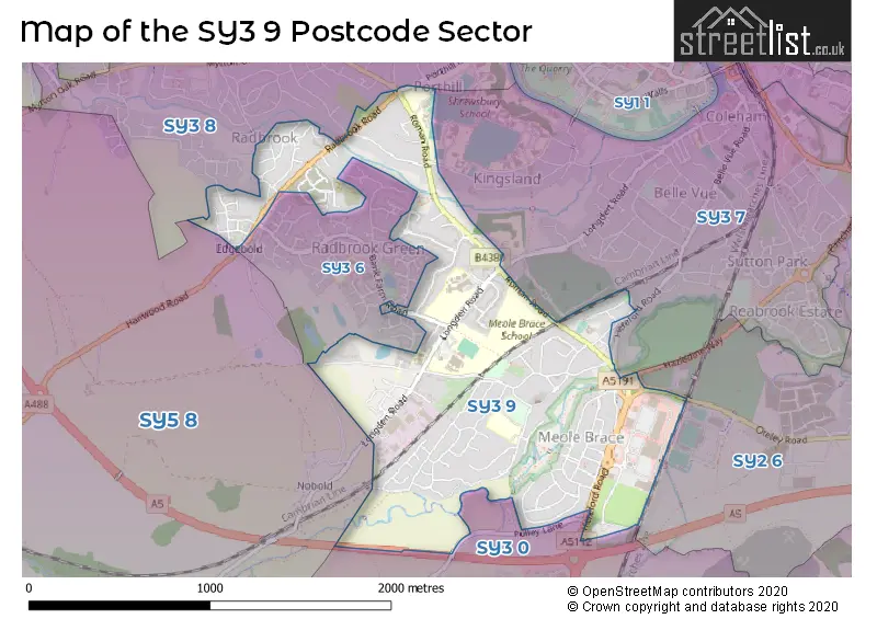
The SY3 9 Postcode shares a border with SY3 6 (SHREWSBURY), SY5 8 (Hanwood, Bowbrook, Longden), SY2 6 (SHREWSBURY), SY3 0 (Bayston Hill, Lyth Bank), SY3 7 (SHREWSBURY) and SY3 8 (SHREWSBURY, Bicton, Bicton Heath).
The sector is within the post town of SHREWSBURY.
SY3 9 is a postcode sector within the SY3 postcode district which is within the SY Shrewsbury postcode area.
The Royal Mail delivery office for the SY3 9 postal sector is the Shrewsbury Delivery Office.
The area of the SY3 9 postcode sector is 1.06 square miles which is 2.75 square kilometres or 679.21 square acres.

Map of the SY3 9 Postcode Sector
Explore the SY3 9 postcode sector by using our free interactive map.
| S | Y | 3 | - | 9 | X | X |
| S | Y | 3 | Space | 9 | Letter | Letter |
Official List of Streets
SHREWSBURY (93 Streets)
Meole Brace (4 Streets)
Unofficial Streets or Alternative Spellings
SHREWSBURY
CROWMEOLE LANE HENLOW RISE KENNEDY ROAD MEOLE HALL GARDENS OAKFIELD ROAD OTELEY ROAD PEMBROKE WAY ROMAN CLOSE SHELTON ROAD SIX ACRES WILTON GREEN COOKERY PLACE GREEN LANE HANWOOD ROAD HAZLEDINE WAY MEOLE BRACE ROUNDABOUT MOOR WAY MOUSECROFT GRANGE PORTHILL ROAD PORTHILL ROUNDABOUT SQUINTER PIP WAY SWEETLAKE THE GREENBayston Hill
HEREFORD ROADSchools and Places of Education Within the SY3 9 Postcode Sector
Bettws Lifehouse
Other independent special school
Kingsland Grange, Shropshire, , SY3 9AH
Head: Mrs Nici Jones
Ofsted Rating: Requires improvement
Inspection: 2023-05-12 (388 days ago)
Website: Visit Bettws Lifehouse Website
Phone: 01686651166
Number of Pupils: 51
Meole Brace Church of England Primary and Nursery
Voluntary controlled school
Church Road, Shrewsbury, Shropshire, SY3 9HG
Head: Mr Henry Bray
Ofsted Rating: Good
Inspection: 2019-11-13 (1664 days ago)
Website: Visit Meole Brace Church of England Primary and Nursery Website
Phone: 01743351027
Number of Pupils: 446
Meole Brace School
Academy converter
Longden Road, Shrewsbury, Shropshire, SY3 9DW
Head: Alan Doust
Ofsted Rating: Serious Weaknesses
Inspection: 2023-05-11 (389 days ago)
Website: Visit Meole Brace School Website
Phone: 01743235961
Number of Pupils: 1343
The Priory School
Academy converter
Longden Road, Shrewsbury, Shropshire, SY3 9EE
Head: Mrs Alison Pope
Ofsted Rating: Outstanding
Inspection: 2013-06-14 (4007 days ago)
Website: Visit The Priory School Website
Phone: 01743284000
Number of Pupils: 849
House Prices in the SY3 9 Postcode Sector
| Type of Property | 2018 Average | 2018 Sales | 2017 Average | 2017 Sales | 2016 Average | 2016 Sales | 2015 Average | 2015 Sales |
|---|---|---|---|---|---|---|---|---|
| Detached | £355,788 | 41 | £371,564 | 59 | £362,472 | 66 | £343,071 | 60 |
| Semi-Detached | £244,571 | 56 | £228,118 | 52 | £254,275 | 29 | £202,612 | 43 |
| Terraced | £190,071 | 14 | £201,712 | 17 | £183,021 | 12 | £142,125 | 12 |
| Flats | £91,000 | 10 | £110,400 | 5 | £104,685 | 3 | £120,000 | 1 |
Important Postcodes SY3 9 in the Postcode Sector
SY3 9BJ is the postcode for Bourne House, Radbrook Centre, Schools Information Technology Support, Bourne House Radbrook Centre, Radbrook Road, and Winston Churchill Building, Radbrook Office Complex
SY3 9BL is the postcode for MAIN BLOCK, Radbrook College, Radbrook Road, and 1950S/SCOLA BLOCK, Radbrook College, Radbrook Road
SY3 9DP is the postcode for Shropshire Nuffield Hospital, Longden Road
SY3 9DS is the postcode for Shropshire County Council, Longden Road
SY3 9DW is the postcode for Roman Road Sports Centre, Longden Road, Meole Brace School, Longden Road, DESIGN AND TECHNOLOGY BLOCK, Meole Brace School, Longden Road, and WEST WING, Meole Brace School, Longden Road
SY3 9EE is the postcode for The Priory School, Longden Road, and SPORTS HALL, The Priory School, Longden Road
SY3 9HG is the postcode for Meole Brace Junior School, Church Road, Meole Brace C.E. Primary and Nursery School, Church Road, Meole Brace C.E. Primary and Nursery School, Church Road, Meole Brace, and Meole Brace C of E Infant School, Church Road
SY3 9JN is the postcode for Louise House, Roman Road, Shaw Healthcare, Louise House, Roman Road, Meole Brace Resource Centre, Roman Road, LOUISE HOUSE, ROMAN ROAD, SHREWSBURY, and Shropshire Council, Louise House, Roman Road
| The SY3 9 Sector is within these Local Authorities |
|
|---|---|
| The SY3 9 Sector is within these Counties |
|
| The SY3 9 Sector is within these Water Company Areas |
|