The SY6 6 postcode sector is within the county of Shropshire.
Did you know? According to the 2021 Census, the SY6 6 postcode sector is home to a bustling 4,206 residents!
Given that each sector allows for 400 unique postcode combinations. Letters C, I, K, M, O and V are not allowed in the last two letters of a postcode. With 202 postcodes already in use, this leaves 198 units available.
The largest settlement in the SY6 6 postal code is CHURCH STRETTON followed by All Stretton, and Leebotwood.
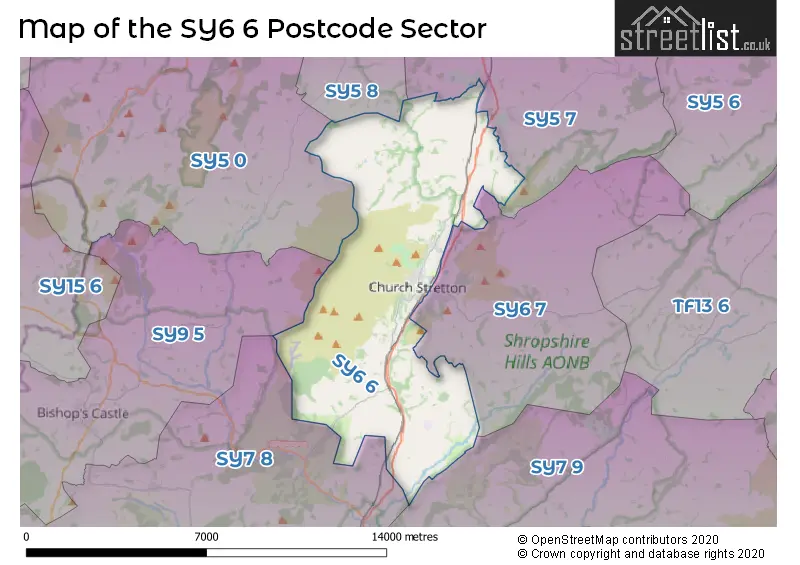
The SY6 6 Postcode shares a border with SY5 0 (Minsterley, Pontesbury, Snailbeach), SY5 7 (Dorrington, Condover, Longnor), SY5 8 (Hanwood, Bowbrook, Longden), SY9 5 (BISHOPS CASTLE, Wentnor, Norbury), SY6 7 (CHURCH STRETTON, Cardington, Wall-under-Heywood), SY7 8 (Clun, Newcastle, LYDBURY NORTH) and SY7 9 (CRAVEN ARMS, Onibury, Diddlebury).
The sector is within the post town of CHURCH STRETTON.
SY6 6 is a postcode sector within the SY6 postcode district which is within the SY Shrewsbury postcode area.
The Royal Mail delivery office for the SY6 6 postal sector is the Church Stretton Delivery Office.
The area of the SY6 6 postcode sector is 30.56 square miles which is 79.14 square kilometres or 19,556.46 square acres.

Map of the SY6 6 Postcode Sector
Explore the SY6 6 postcode sector by using our free interactive map.
| S | Y | 6 | - | 6 | X | X |
| S | Y | 6 | Space | 6 | Letter | Letter |
Official List of Streets
Alcaston (2 Streets)
CHURCH STRETTON (46 Streets)
All Stretton (10 Streets)
Acton Scott (1 Streets)
Leebotwood (2 Streets)
Little Stretton (2 Streets)
Crossways (1 Streets)
Schools and Places of Education Within the SY6 6 Postcode Sector
Church Stretton School
Academy converter
Shrewsbury Road, Church Stretton, Shropshire, SY6 6EX
Head: Mr John Parr
Ofsted Rating: Good
Inspection: 2019-02-06 (1936 days ago)
Website: Visit Church Stretton School Website
Phone: 01694722209
Number of Pupils: 541
St Lawrence CofE Primary School
Voluntary controlled school
Shrewsbury Road, Church Stretton, Shropshire, SY6 6EX
Head: Mr Alan Brannen
Ofsted Rating: Good
Inspection: 2018-10-03 (2062 days ago)
Website: Visit St Lawrence CofE Primary School Website
Phone: 01694722682
Number of Pupils: 256
House Prices in the SY6 6 Postcode Sector
| Type of Property | 2018 Average | 2018 Sales | 2017 Average | 2017 Sales | 2016 Average | 2016 Sales | 2015 Average | 2015 Sales |
|---|---|---|---|---|---|---|---|---|
| Detached | £373,026 | 40 | £362,708 | 36 | £337,457 | 29 | £335,617 | 38 |
| Semi-Detached | £241,471 | 17 | £227,425 | 20 | £209,702 | 32 | £210,142 | 18 |
| Terraced | £261,250 | 6 | £228,680 | 10 | £184,571 | 7 | £164,000 | 7 |
| Flats | £138,735 | 17 | £134,941 | 17 | £125,977 | 24 | £123,002 | 29 |
Important Postcodes SY6 6 in the Postcode Sector
SY6 6BL is the postcode for Church Stretton Medical Centre, Easthope Road
SY6 6DQ is the postcode for Church Stretton Library, Church Street
SY6 6EX is the postcode for SCOLA BLOCK, Church Stretton School, Shrewsbury Road, St. Lawrence C of E Primary School, Shrewsbury Road, and Church Stretton School, Shrewsbury Road
| The SY6 6 Sector is within these Local Authorities |
|
|---|---|
| The SY6 6 Sector is within these Counties |
|
| The SY6 6 Sector is within these Water Company Areas |
|