The TA11 7 postcode sector is within the county of Somerset.
Did you know? According to the 2021 Census, the TA11 7 postcode sector is home to a bustling 2,814 residents!
Given that each sector allows for 400 unique postcode combinations. Letters C, I, K, M, O and V are not allowed in the last two letters of a postcode. With 158 postcodes already in use, this leaves 242 units available.
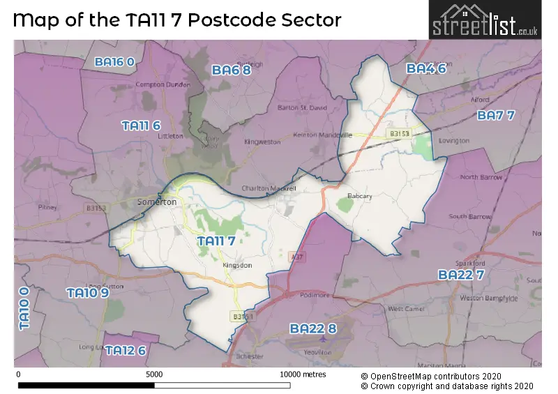
The largest settlement in the TA11 7 postal code is SOMERTON followed by Charlton Adam, and Kingsdon.
The TA11 7 Postcode shares a border with TA10 9 (LANGPORT, Long Sutton, Pitney), TA11 6 (SOMERTON, Keinton Mandeville, Compton Dundon), BA4 6 (Evercreech, Ditcheat, East Pennard), BA6 8 (GLASTONBURY, Baltonsborough, Butleigh), BA7 7 (CASTLE CARY, Ansford, Lovington), BA22 7 (Sparkford, Queen Camel, North Cadbury) and BA22 8 (Ilchester, Houndstone, Tintinhull).
The sector is within the post town of SOMERTON.
TA11 7 is a postcode sector within the TA11 postcode district which is within the TA Taunton postcode area.
The Royal Mail delivery office for the TA11 7 postal sector is the Somerton Delivery Office.
The area of the TA11 7 postcode sector is 17.83 square miles which is 46.19 square kilometres or 11,413.80 square acres.
Waterways within the TA11 7 postcode sector include the River Cary.


Map of the TA11 7 Postcode Sector
Explore the TA11 7 postcode sector by using our free interactive map.
| T | A | 1 | 1 | - | 7 | X | X |
| T | A | 1 | 1 | Space | 7 | Letter | Letter |
Official List of Streets
SOMERTON (28 Streets)
Babcary (7 Streets)
Charlton Mackrell (4 Streets)
Charlton Adam (16 Streets)
Kingsdon (10 Streets)
East Lydford (2 Streets)
West Lydford (5 Streets)
Unofficial Streets or Alternative Spellings
West Camel
STEART HILLKeinton Mandeville
BABCARY LANECharlton Adam
ARNOT COURTSOMERTON
BRUNEL CLOSE COW SQUARE LION MEWS PERRY HILL ROAD SUTTON ROADSchools and Places of Education Within the TA11 7 Postcode Sector
Charlton Mackrell CofE Primary School
Voluntary controlled school
Bonfire Lane, Somerton, Somerset, TA11 7BN
Head: Mrs Rebecca Cawley
Ofsted Rating: Good
Inspection: 2023-02-03 (490 days ago)
Website: Visit Charlton Mackrell CofE Primary School Website
Phone: 01458223329
Number of Pupils: 84
House Prices in the TA11 7 Postcode Sector
| Type of Property | 2018 Average | 2018 Sales | 2017 Average | 2017 Sales | 2016 Average | 2016 Sales | 2015 Average | 2015 Sales |
|---|---|---|---|---|---|---|---|---|
| Detached | £545,769 | 18 | £492,780 | 22 | £428,513 | 23 | £377,950 | 18 |
| Semi-Detached | £342,375 | 12 | £293,708 | 15 | £286,827 | 11 | £256,773 | 11 |
| Terraced | £360,742 | 6 | £235,750 | 8 | £230,592 | 14 | £266,842 | 19 |
| Flats | £98,333 | 3 | £0 | 0 | £0 | 0 | £87,500 | 1 |
Important Postcodes TA11 7 in the Postcode Sector
TA11 7NL is the postcode for Monteclefe C of E Academy, School Lane, Kirkham Street
TA11 7PB is the postcode for Buttercross Health Centre, Behind Berry
| The TA11 7 Sector is within these Local Authorities |
|
|---|---|
| The TA11 7 Sector is within these Counties |
|
| The TA11 7 Sector is within these Water Company Areas |
|
Tourist Attractions within the TA11 7 Postcode Area
We found 1 visitor attractions within the TA11 postcode area
| Lytes Cary Manor |
|---|
| Historic Properties |
| Historic House / House and Garden / Palace |
| View Lytes Cary Manor on Google Maps |