The TF1 6 postcode sector is within the county of Shropshire.
Did you know? According to the 2021 Census, the TF1 6 postcode sector is home to a bustling 10,466 residents!
Given that each sector allows for 400 unique postcode combinations. Letters C, I, K, M, O and V are not allowed in the last two letters of a postcode. With 205 postcodes already in use, this leaves 195 units available.
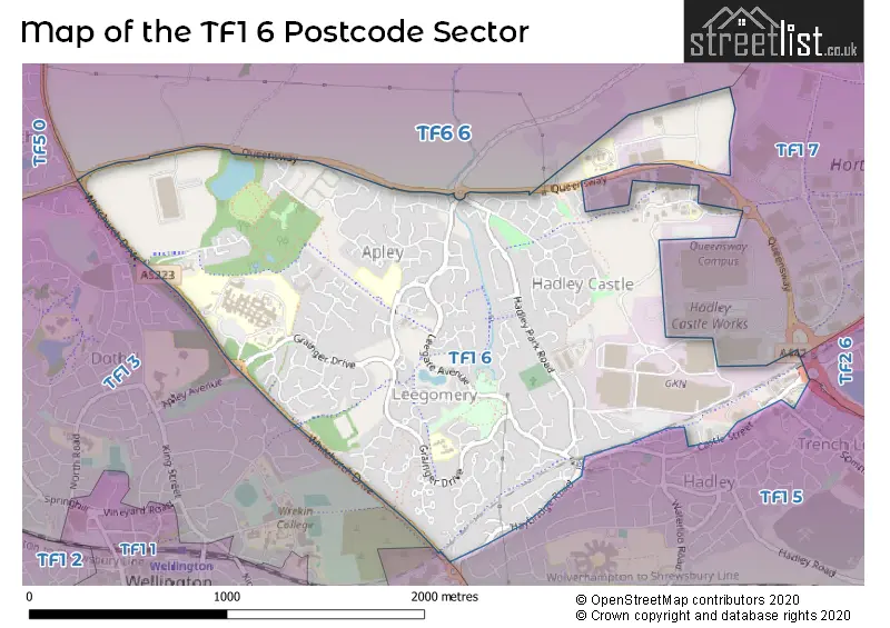
The largest settlement in the TF1 6 postal code is Leegomery followed by Apley, and Hadley.
The TF1 6 Postcode shares a border with TF1 3 (Wellington, TELFORD), TF1 5 (Hadley, Ketley, TELFORD), TF2 6 (Oakengates, Trench, TELFORD), TF5 0 (TELFORD, Admaston, Bratton), TF6 6 (High Ercall, Waters Upton, Crudgington) and TF1 2 (Wellington, Arleston).
The sector is within the post town of TELFORD.
TF1 6 is a postcode sector within the TF1 postcode district which is within the TF Telford postcode area.
The Royal Mail delivery office for the TF1 6 postal sector is the Wellington (tf) Delivery Office.
The area of the TF1 6 postcode sector is 1.66 square miles which is 4.30 square kilometres or 1,062.42 square acres.

Map of the TF1 6 Postcode Sector
Explore the TF1 6 postcode sector by using our free interactive map.
| T | F | 1 | - | 6 | X | X |
| T | F | 1 | Space | 6 | Letter | Letter |
Official List of Streets
Leegomery (60 Streets)
Apley (65 Streets)
Hadley (16 Streets)
Unofficial Streets or Alternative Spellings
Weather Forecast for TF1 6
Press Button to Show Forecast for Telford
| Time Period | Icon | Description | Temperature | Rain Probability | Wind |
|---|---|---|---|---|---|
| 03:00 to 06:00 | Cloudy | 8.0°C (feels like 5.0°C) | 6.00% | SSE 13 mph | |
| 06:00 to 09:00 | Cloudy | 8.0°C (feels like 5.0°C) | 5.00% | SE 16 mph | |
| 09:00 to 12:00 | Cloudy | 11.0°C (feels like 8.0°C) | 5.00% | SSE 18 mph | |
| 12:00 to 15:00 | Cloudy | 14.0°C (feels like 10.0°C) | 9.00% | SSE 18 mph | |
| 15:00 to 18:00 | Cloudy | 14.0°C (feels like 11.0°C) | 14.00% | S 13 mph | |
| 18:00 to 21:00 | Light rain shower (day) | 12.0°C (feels like 10.0°C) | 33.00% | S 9 mph | |
| 21:00 to 00:00 | Overcast | 10.0°C (feels like 9.0°C) | 16.00% | SSE 7 mph |
Press Button to Show Forecast for Telford
| Time Period | Icon | Description | Temperature | Rain Probability | Wind |
|---|---|---|---|---|---|
| 00:00 to 03:00 | Cloudy | 9.0°C (feels like 8.0°C) | 10.00% | SSE 4 mph | |
| 03:00 to 06:00 | Cloudy | 8.0°C (feels like 7.0°C) | 8.00% | SSE 4 mph | |
| 06:00 to 09:00 | Cloudy | 8.0°C (feels like 7.0°C) | 6.00% | SSE 4 mph | |
| 09:00 to 12:00 | Cloudy | 11.0°C (feels like 10.0°C) | 6.00% | SSE 4 mph | |
| 12:00 to 15:00 | Cloudy | 13.0°C (feels like 13.0°C) | 10.00% | SE 4 mph | |
| 15:00 to 18:00 | Cloudy | 15.0°C (feels like 14.0°C) | 14.00% | ESE 4 mph | |
| 18:00 to 21:00 | Overcast | 14.0°C (feels like 13.0°C) | 17.00% | NE 4 mph | |
| 21:00 to 00:00 | Cloudy | 11.0°C (feels like 10.0°C) | 10.00% | NNW 7 mph |
Press Button to Show Forecast for Telford
| Time Period | Icon | Description | Temperature | Rain Probability | Wind |
|---|---|---|---|---|---|
| 00:00 to 03:00 | Cloudy | 10.0°C (feels like 9.0°C) | 17.00% | NNW 7 mph | |
| 03:00 to 06:00 | Cloudy | 9.0°C (feels like 8.0°C) | 17.00% | NNW 7 mph | |
| 06:00 to 09:00 | Overcast | 9.0°C (feels like 8.0°C) | 15.00% | NNW 7 mph | |
| 09:00 to 12:00 | Overcast | 12.0°C (feels like 11.0°C) | 13.00% | NW 9 mph | |
| 12:00 to 15:00 | Cloudy | 15.0°C (feels like 14.0°C) | 9.00% | NNW 9 mph | |
| 15:00 to 18:00 | Cloudy | 16.0°C (feels like 14.0°C) | 8.00% | N 9 mph | |
| 18:00 to 21:00 | Partly cloudy (day) | 15.0°C (feels like 13.0°C) | 5.00% | NNW 9 mph | |
| 21:00 to 00:00 | Clear night | 12.0°C (feels like 10.0°C) | 3.00% | N 9 mph |
Schools and Places of Education Within the TF1 6 Postcode Sector
Millbrook Primary School
Community school
Grainger Drive, Telford, Shropshire, TF1 6UJ
Head: Miss Kirsty Osman
Ofsted Rating: Good
Inspection: 2023-10-25 (188 days ago)
Website: Visit Millbrook Primary School Website
Phone: 01952387640
Number of Pupils: 465
House Prices in the TF1 6 Postcode Sector
| Type of Property | 2018 Average | 2018 Sales | 2017 Average | 2017 Sales | 2016 Average | 2016 Sales | 2015 Average | 2015 Sales |
|---|---|---|---|---|---|---|---|---|
| Detached | £239,523 | 62 | £240,026 | 105 | £225,271 | 115 | £210,919 | 107 |
| Semi-Detached | £148,869 | 43 | £139,889 | 41 | £151,604 | 82 | £145,634 | 59 |
| Terraced | £122,777 | 31 | £131,133 | 41 | £127,005 | 37 | £128,391 | 37 |
| Flats | £70,850 | 10 | £67,625 | 4 | £60,000 | 4 | £61,000 | 4 |
Important Postcodes TF1 6 in the Postcode Sector
TF1 6AJ is the postcode for The Jigsaw School, Queensway, The Jigsaw School, Queensway, Hadley, and Queensway North School, Queensway, Hadley
TF1 6FQ is the postcode for Apley Wood Primary School, Pool Farm Avenue, and APLEY WOOD PRIMARY SCHOOL, POOL FARM AVENUE, APLEY
TF1 6RH is the postcode for Severn Hospice, Apley Castle
TF1 6TF is the postcode for Shrewsbury and Telford Hospital NHS Trust, Princess Royal Hospital, and Shrewsbury and Telford Hospital NHS Trust, Princess Royal Hospital, Grainger Drive
TF1 6UJ is the postcode for Millbrook Primary School, Grainger Drive, and Millbrook Primary School, Grainger Drive, Apley
| The TF1 6 Sector is within these Local Authorities |
|
|---|---|
| The TF1 6 Sector is within these Counties |
|
| The TF1 6 Sector is within these Water Company Areas |
|