The TN29 0 postcode sector is within the county of Kent.
Did you know? According to the 2021 Census, the TN29 0 postcode sector is home to a bustling 7,184 residents!
Given that each sector allows for 400 unique postcode combinations. Letters C, I, K, M, O and V are not allowed in the last two letters of a postcode. With 260 postcodes already in use, this leaves 140 units available.
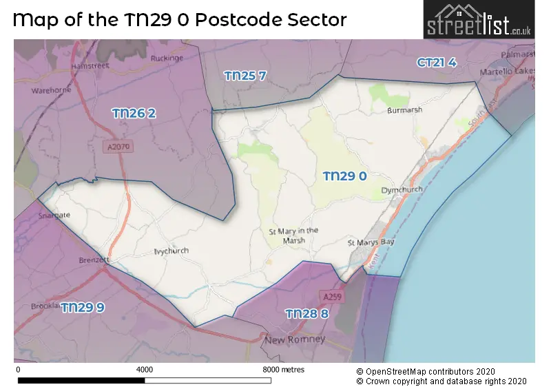
The largest settlement in the TN29 0 postal code is Dymchurch followed by St. Marys Bay, and Burmarsh.
The TN29 0 Postcode shares a border with TN25 7 (Aldington, Kingsnorth, Finberry), TN26 2 (Hamstreet, Ruckinge, Appledore), CT21 4 (HYTHE, Lympne, Saltwood), TN28 8 (NEW ROMNEY, Greatstone, Littlestone) and TN29 9 (Lydd, Lydd On Sea, Brookland).
The sector is within the post town of ROMNEY MARSH.
TN29 0 is a postcode sector within the TN29 postcode district which is within the TN Tonbridge postcode area.
The Royal Mail delivery office for the TN29 0 postal sector is the New Romney Delivery Office.
The area of the TN29 0 postcode sector is 20.69 square miles which is 53.59 square kilometres or 13,241.19 square acres.
The TN29 0 postcode sector is crossed by the A2070 Major A road.


Map of the TN29 0 Postcode Sector
Explore the TN29 0 postcode sector by using our free interactive map.
| T | N | 2 | 9 | - | 0 | X | X |
| T | N | 2 | 9 | Space | 0 | Letter | Letter |
Official List of Streets
Ivychurch (7 Streets)
Old Romney (3 Streets)
St. Marys Bay (47 Streets)
Dymchurch (59 Streets)
Burmarsh (8 Streets)
St. Mary In The Marsh (8 Streets)
Brenzett (2 Streets)
Newchurch (9 Streets)
Snargate (2 Streets)
Unofficial Streets or Alternative Spellings
NEW ROMNEY
HOPE LANEHYTHE
DYMCHURCH ROADSchools and Places of Education Within the TN29 0 Postcode Sector
Dymchurch Primary School
Academy converter
New Hall Close, Romney Marsh, Kent, TN29 0LE
Head: Mr Iain Rudgyard
Ofsted Rating: Requires improvement
Inspection: 2022-04-27 (771 days ago)
Website: Visit Dymchurch Primary School Website
Phone: 01303872377
Number of Pupils: 159
House Prices in the TN29 0 Postcode Sector
| Type of Property | 2018 Average | 2018 Sales | 2017 Average | 2017 Sales | 2016 Average | 2016 Sales | 2015 Average | 2015 Sales |
|---|---|---|---|---|---|---|---|---|
| Detached | £347,300 | 57 | £318,582 | 82 | £344,257 | 59 | £267,029 | 83 |
| Semi-Detached | £258,774 | 38 | £241,628 | 61 | £224,278 | 54 | £203,267 | 56 |
| Terraced | £245,600 | 10 | £167,400 | 5 | £218,000 | 5 | £173,667 | 6 |
| Flats | £164,874 | 4 | £150,000 | 1 | £213,214 | 7 | £138,317 | 3 |
Important Postcodes TN29 0 in the Postcode Sector
TN29 0LE is the postcode for Dymchurch Primary School, New Hall Close, and Dymchurch Cp School, New Hall Close
TN29 0TD is the postcode for Martello Medical Practice, 20 Chapel Road
| The TN29 0 Sector is within these Local Authorities |
|
|---|---|
| The TN29 0 Sector is within these Counties |
|
| The TN29 0 Sector is within these Water Company Areas |
|