The TW8 0 postcode sector is within the county of Greater London.
Did you know? According to the 2021 Census, the TW8 0 postcode sector is home to a bustling 12,447 residents!
Given that each sector allows for 400 unique postcode combinations. Letters C, I, K, M, O and V are not allowed in the last two letters of a postcode. With 211 postcodes already in use, this leaves 189 units available.
The TW8 0 postal code covers the settlement of BRENTFORD .
The TW8 0 Postcode shares a border with TW8 8 (BRENTFORD , ISLEWORTH ), W4 5 (CHISWICK ), TW8 9 (BRENTFORD ) and W4 3 (CHISWICK ).
The sector is within the post town of BRENTFORD.
TW8 0 is a postcode sector within the TW8 postcode district which is within the TW Twickenham postcode area.
The Royal Mail delivery office for the TW8 0 postal sector is the Brentford & Isleworth Delivery Office.
The area of the TW8 0 postcode sector is 0.38 square miles which is 0.99 square kilometres or 245.03 square acres.
The TW8 0 postcode sector is crossed by the M4 motorway.

Map of the TW8 0 Postcode Sector
Explore the TW8 0 postcode sector by using our free interactive map.
| T | W | 8 | - | 0 | X | X |
| T | W | 8 | Space | 0 | Letter | Letter |
Official List of Streets
BRENTFORD (60 Streets)
Unofficial Streets or Alternative Spellings
BRENTFORD
CLAYPONDS AVENUE DOCK ROAD HALF ACRE BACK LANE BRENTFORD HIGH STREET CENTAUR COURT CHISWICK HIGH ROAD (NORTH CIRCULAR ROAD) DAHLIA BRIDGE FERRY WHARF HERITAGE WALK MERCURY ROAD PEGASUS COURT PHOENIX COURT POINT WHARF RIVERS HOUSE SMITH HILL STRAND-ON-THE-GREEN THAMES ROW THAMESSIDE CENTRE TITAN COURT WATERMANS COURTHounslow
CHISWICK HIGH ROAD KEW BRIDGE COURT SPRING GROVERICHMOND
KEW ROADHammersmith and Fulham
GREAT WEST ROADEaling
WINDMILL ROAD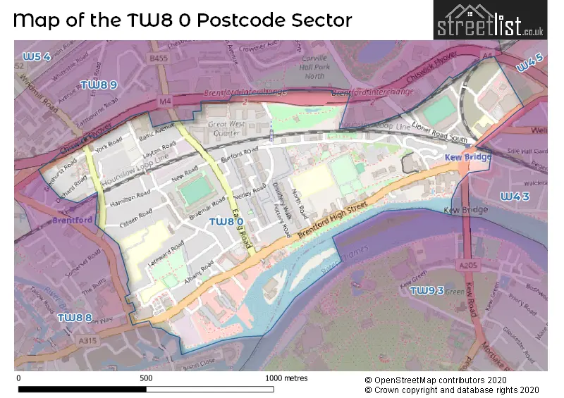
House Prices in the TW8 0 Postcode Sector
| Type of Property | 2018 Average | 2018 Sales | 2017 Average | 2017 Sales | 2016 Average | 2016 Sales | 2015 Average | 2015 Sales |
|---|---|---|---|---|---|---|---|---|
| Detached | £0 | 0 | £0 | 0 | £563,000 | 1 | £0 | 0 |
| Semi-Detached | £666,250 | 4 | £527,500 | 2 | £558,333 | 3 | £516,667 | 3 |
| Terraced | £537,260 | 19 | £561,437 | 23 | £601,609 | 21 | £523,884 | 37 |
| Flats | £484,442 | 119 | £539,722 | 196 | £596,790 | 376 | £515,510 | 526 |
Important Postcodes TW8 0 in the Postcode Sector
TW8 0BJ is the postcode for Green Dragon School, North Road
TW8 0DS is the postcode for Watermans Arts Centre, 40 High Street
TW8 0HJ is the postcode for Brentford Fountain Leisure Centre, 658 ChiswickHigh Road, Chiswick, and Brentford Fountain Leisure Centre, 658 Chiswick High Road
TW8 0JJ is the postcode for Brentford County Court, Alexandra Road
TW8 0ND is the postcode for Alexandra House, Albany Road, and ALEXANDRA HOUSE, ALBANY ROAD, BRENTFORD
TW8 0PG is the postcode for CURIE BUILDING, Brentford School for Girls, 5 Boston Manor Road, PANKHURST BUILDING, Brentford School for Girls, 5 Boston Manor Road, and MOLES BUILDING, Brentford School for Girls, 5 Boston Manor Road
TW8 0PN is the postcode for ST PAULS C OF E PRIMARY SCHOOL, ST PAULS ROAD, BRENTFORD, St. Pauls C of E Primary School, St. Pauls Road, and St Pauls C of E Primary School, St Pauls Road
| The TW8 0 Sector is within these Local Authorities |
|
|---|---|
| The TW8 0 Sector is within these Counties |
|
| The TW8 0 Sector is within these Water Company Areas |
|