The WA10 2 postcode sector is within the county of Merseyside.
Did you know? According to the 2021 Census, the WA10 2 postcode sector is home to a bustling 5,202 residents!
Given that each sector allows for 400 unique postcode combinations. Letters C, I, K, M, O and V are not allowed in the last two letters of a postcode. With 197 postcodes already in use, this leaves 203 units available.
The largest settlements in the WA10 2 postal code are ST. HELENS and Dentons Green.
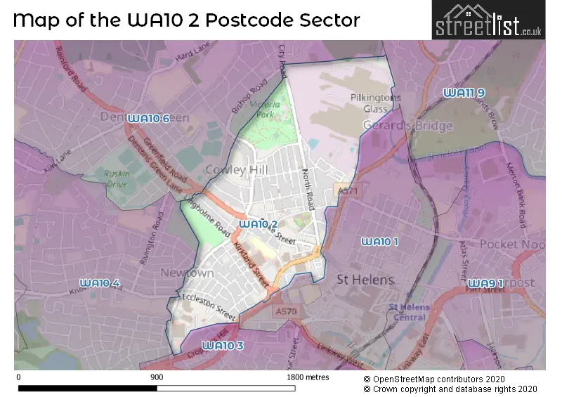
The WA10 2 Postcode shares a border with WA10 1 (ST. HELENS), WA10 3 (ST. HELENS, Grange Park), WA10 4 (ST. HELENS, Eccleston), WA10 6 (ST. HELENS, Dentons Green, Windle) and WA11 9 (ST. HELENS, Haydock).
The sector is within the post town of ST. HELENS.
WA10 2 is a postcode sector within the WA10 postcode district which is within the WA Warrington postcode area.
The Royal Mail delivery office for the WA10 2 postal sector is the St Helens Delivery Office.
The area of the WA10 2 postcode sector is 0.54 square miles which is 1.39 square kilometres or 344.48 square acres.

Map of the WA10 2 Postcode Sector
Explore the WA10 2 postcode sector by using our free interactive map.
| W | A | 1 | 0 | - | 2 | X | X |
| W | A | 1 | 0 | Space | 2 | Letter | Letter |
Official List of Streets
ST. HELENS (98 Streets)
Unofficial Streets or Alternative Spellings
ST. HELENS
BISHOP ROAD CAMBRIDGE ROAD CARLTON STREET CLAUGHTON STREET COLLEGE STREET DOULTON STREET HORACE STREET KITCHENER STREET KNOWSLEY ROAD NEW CROSS STREET SOUTH PRESCOT ROAD SILKSTONE STREET WESTFIELD STREETSchools and Places of Education Within the WA10 2 Postcode Sector
St Mary & St Thomas' CofE Primary School
Academy converter
Barton Close, St Helens, Merseyside, WA10 2HS
Head: Lyndsey Lewis
Ofsted Rating: Outstanding
Inspection: 2019-02-27 (1912 days ago)
Website: Visit St Mary & St Thomas' CofE Primary School Website
Phone: 01744734320
Number of Pupils: 224
House Prices in the WA10 2 Postcode Sector
| Type of Property | 2018 Average | 2018 Sales | 2017 Average | 2017 Sales | 2016 Average | 2016 Sales | 2015 Average | 2015 Sales |
|---|---|---|---|---|---|---|---|---|
| Detached | £181,500 | 2 | £196,883 | 13 | £193,061 | 30 | £172,806 | 25 |
| Semi-Detached | £135,841 | 11 | £158,486 | 29 | £147,266 | 45 | £138,216 | 29 |
| Terraced | £88,102 | 58 | £90,388 | 62 | £100,845 | 42 | £87,725 | 50 |
| Flats | £90,167 | 6 | £91,000 | 1 | £62,000 | 4 | £69,000 | 5 |
Important Postcodes WA10 2 in the Postcode Sector
WA10 2AP is the postcode for St. Helens & Knowsley Community Health NHS Trust, The Beeches, St. Helens & Knowsley Community Health NHS Trust, The Balker, St. Helens & Knowsley Community Health NHS Trust, The Hollies, Cowley Hill Lane, and St. Helens & Knowsley Community Health NHS Trust, The Gables
WA10 2AW is the postcode for 5 Boroughs Partnership NHS Foundation Trust, The Elms
WA10 2DJ is the postcode for LOWE HOUSE PRIMARY CARE RESOURCE CENTRE, 103, Crab Street, and Lowe House Health Care Resource Centre, 103 Crab Street
WA10 2EW is the postcode for St. Helens Council, 130 Napier Street
WA10 2HS is the postcode for St. Marys & St. Thomas C of E Primary School, Barton Close
WA10 2JZ is the postcode for Windle Pilkington House, King Street
WA10 2LT is the postcode for Queens Park Health And Fitness, Boundary Road, Queens Park Leisure Centre, Boundary Road, and St. Helens Metropolitan Borough Council, Queens Park Leisure Centre, Boundary Road
WA10 2SP is the postcode for St. Helens Metropolitan Borough Council, Lord Street Day Centre, Lord Street
| The WA10 2 Sector is within these Local Authorities |
|
|---|---|
| The WA10 2 Sector is within these Counties |
|
| The WA10 2 Sector is within these Water Company Areas |
|