The WA5 4 postcode sector stands on the Cheshire and Merseyside border.
Did you know? According to the 2021 Census, the WA5 4 postcode sector is home to a bustling 3,778 residents!
Given that each sector allows for 400 unique postcode combinations. Letters C, I, K, M, O and V are not allowed in the last two letters of a postcode. With 126 postcodes already in use, this leaves 274 units available.
The largest settlements in the WA5 4 postal code are Burtonwood and Collins Green.
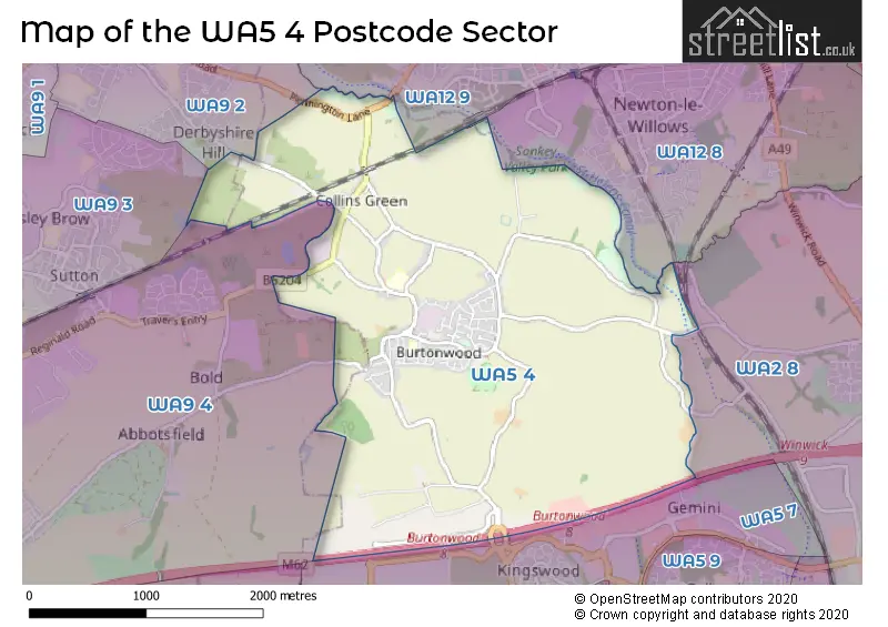
The WA5 4 Postcode shares a border with WA9 3 (ST. HELENS), WA2 8 (WARRINGTON, Winwick, Winwick Quay), WA5 7 (Westbrook), WA9 2 (ST. HELENS), WA9 4 (Clock Face, ST. HELENS, Sutton Manor), WA12 8 (NEWTON-LE-WILLOWS) and WA12 9 (NEWTON-LE-WILLOWS).
The sector is within the post town of WARRINGTON.
WA5 4 is a postcode sector within the WA5 postcode district which is within the WA Warrington postcode area.
The Royal Mail delivery office for the WA5 4 postal sector is the Newton Le Willows Delivery Office.
The area of the WA5 4 postcode sector is 4.04 square miles which is 10.45 square kilometres or 2,583.12 square acres.
The WA5 4 postcode sector is crossed by the M62 motorway.
Waterways within the WA5 4 postcode sector include the Sankey Brook.

Map of the WA5 4 Postcode Sector
Explore the WA5 4 postcode sector by using our free interactive map.
| W | A | 5 | - | 4 | X | X |
| W | A | 5 | Space | 4 | Letter | Letter |
Official List of Streets
Burtonwood (66 Streets)
Unofficial Streets or Alternative Spellings
NEWTON-LE-WILLOWS
COMMON ROAD BURTONWOOD ROUNDABOUT CAMBOURNE ROAD CROSS STREET GLEAVE ROAD LIMEKILN LANE LIMEKILN ROUNDABOUT OLD ALDER LANE TERRY ONEILL WAY WRIGHTS LANEST. HELENS
FLEET LANE PENNINGTON LANEBold
GORSEY LANESchools and Places of Education Within the WA5 4 Postcode Sector
Burtonwood Community Primary School
Academy converter
Green Lane, Warrington, Cheshire, WA5 4AQ
Head: Mr Jason Heatley
Ofsted Rating: Good
Inspection: 2023-05-24 (365 days ago)
Website: Visit Burtonwood Community Primary School Website
Phone: 01925224072
Number of Pupils: 210
St Paul of the Cross Catholic Primary School
Voluntary aided school
Milnthorpe Road, Warrington, Cheshire, WA5 4PN
Head: Mrs Clare Abram
Ofsted Rating: Good
Inspection: 2021-07-07 (1051 days ago)
Website: Visit St Paul of the Cross Catholic Primary School Website
Phone: 01925224686
Number of Pupils: 143
House Prices in the WA5 4 Postcode Sector
| Type of Property | 2018 Average | 2018 Sales | 2017 Average | 2017 Sales | 2016 Average | 2016 Sales | 2015 Average | 2015 Sales |
|---|---|---|---|---|---|---|---|---|
| Detached | £239,994 | 9 | £251,600 | 5 | £308,000 | 7 | £204,500 | 4 |
| Semi-Detached | £133,308 | 20 | £142,194 | 31 | £142,167 | 26 | £125,938 | 17 |
| Terraced | £114,522 | 23 | £85,928 | 18 | £123,043 | 15 | £108,405 | 11 |
| Flats | £0 | 0 | £0 | 0 | £0 | 0 | £108,000 | 1 |
Important Postcodes WA5 4 in the Postcode Sector
WA5 4AQ is the postcode for Burtonwood Community Primary School, Green Lane, and Burtonwood Community Primary School, Green Lane, Burtonwood
WA5 4LH is the postcode for Warrington Borough Council, Burtonwood Community Centre, Green Jones Brow
WA5 4PN is the postcode for St. Paul of the Cross Catholic Primary School, Milnthorpe Road, and St. Paul of the Cross Catholic Primary School, Milnthorpe Road, Burtonwood
| The WA5 4 Sector is within these Local Authorities |
|
|---|---|
| The WA5 4 Sector is within these Counties |
|
| The WA5 4 Sector is within these Water Company Areas |
|