The WD7 7 postcode sector is within the county of Hertfordshire.
Did you know? According to the 2021 Census, the WD7 7 postcode sector is home to a bustling 3,363 residents!
Given that each sector allows for 400 unique postcode combinations. Letters C, I, K, M, O and V are not allowed in the last two letters of a postcode. With 124 postcodes already in use, this leaves 276 units available.
The largest settlements in the WD7 7 postal code are RADLETT and SHENLEY .
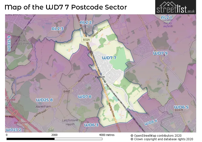
The WD7 7 Postcode shares a border with WD7 9 (SHENLEY ), WD6 4 (BOREHAMWOOD ), AL2 2 (PARK STREET, FROGMORE, ST ALBANS), AL2 3 (BRICKET WOOD, CHISWELL GREEN, ST ALBANS), WD6 3 (ELSTREE ), WD25 8 (ALDENHAM , WATFORD , LETCHMORE HEATH ) and WD7 8 (RADLETT ).
The sector is within the post town of RADLETT.
WD7 7 is a postcode sector within the WD7 postcode district which is within the WD Watford postcode area.
The Royal Mail delivery office for the WD7 7 postal sector is the Radlett Delivery Office.
The area of the WD7 7 postcode sector is 2.70 square miles which is 6.99 square kilometres or 1,728.03 square acres.
Waterways within the WD7 7 postcode sector include the River Colne.

Map of the WD7 7 Postcode Sector
Explore the WD7 7 postcode sector by using our free interactive map.
| W | D | 7 | - | 7 | X | X |
| W | D | 7 | Space | 7 | Letter | Letter |
Official List of Streets
RADLETT (38 Streets)
Schools and Places of Education Within the WD7 7 Postcode Sector
Newberries Primary School
Community school
Newberries Avenue, Radlett, Hertfordshire, WD7 7EL
Head: Ms Ness Peters
Ofsted Rating: Good
Inspection: 2022-11-30 (543 days ago)
Website: Visit Newberries Primary School Website
Phone: 01923857180
Number of Pupils: 179
House Prices in the WD7 7 Postcode Sector
| Type of Property | 2018 Average | 2018 Sales | 2017 Average | 2017 Sales | 2016 Average | 2016 Sales | 2015 Average | 2015 Sales |
|---|---|---|---|---|---|---|---|---|
| Detached | £1,335,500 | 19 | £1,360,357 | 35 | £1,437,406 | 32 | £1,254,139 | 36 |
| Semi-Detached | £750,350 | 7 | £866,600 | 5 | £792,857 | 7 | £683,125 | 4 |
| Terraced | £727,500 | 2 | £657,260 | 5 | £701,000 | 2 | £735,800 | 3 |
| Flats | £436,498 | 25 | £393,478 | 23 | £345,958 | 13 | £350,640 | 24 |
Important Postcodes WD7 7 in the Postcode Sector
WD7 7EL is the postcode for Newberries Primary School, Newberries Avenue
WD7 7JQ is the postcode for Red House Surgery, 124 Watling Street
WD7 7LQ is the postcode for Hertsmere Jewish Primary School, Watling Street
| The WD7 7 Sector is within these Local Authorities |
|
|---|---|
| The WD7 7 Sector is within these Counties |
|
| The WD7 7 Sector is within these Water Company Areas |
|