The WF1 5 postcode sector is within the county of West Yorkshire.
Did you know? According to the 2021 Census, the WF1 5 postcode sector is home to a bustling 7,328 residents!
Given that each sector allows for 400 unique postcode combinations. Letters C, I, K, M, O and V are not allowed in the last two letters of a postcode. With 224 postcodes already in use, this leaves 176 units available.
The largest settlement in the WF1 5 postal code is WAKEFIELD followed by Kirkthorpe, and Heath.
The WF1 5 Postcode shares a border with WF1 1 (WAKEFIELD), WF1 4 (WAKEFIELD, Eastmoor), WF2 6 (WAKEFIELD, Walton, Newmillerdam), WF2 7 (WAKEFIELD, Newmillerdam, Milnthorpe), WF2 8 (WAKEFIELD), WF4 1 (Crofton, Sharlston Common, New Crofton), WF6 1 (NORMANTON, Normanton Industrial Estate) and WF6 2 (NORMANTON, Altofts).
The sector is within the post town of WAKEFIELD.
WF1 5 is a postcode sector within the WF1 postcode district which is within the WF Wakefield postcode area.
The Royal Mail delivery office for the WF1 5 postal sector is the Wakefield Delivery Office.
The area of the WF1 5 postcode sector is 4.08 square miles which is 10.56 square kilometres or 2,609.81 square acres.
Waterways within the WF1 5 postcode sector include the Aire and Calder Navigation, River Calder, Barnsley Canal.

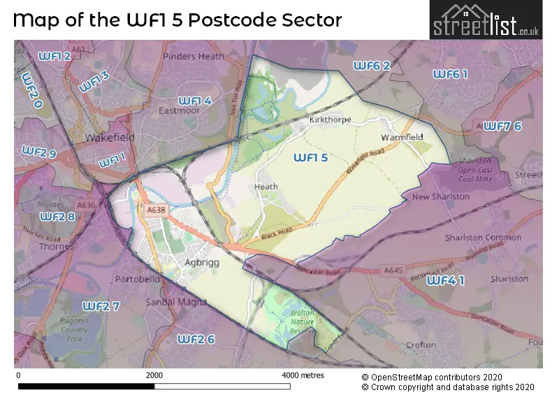
Map of the WF1 5 Postcode Sector
Explore the WF1 5 postcode sector by using our free interactive map.
| W | F | 1 | - | 5 | X | X |
| W | F | 1 | Space | 5 | Letter | Letter |
Official List of Streets
WAKEFIELD (115 Streets)
Heath (7 Streets)
Agbrigg (1 Streets)
Walton (3 Streets)
Kirkthorpe (7 Streets)
Warmfield (4 Streets)
Sandal (2 Streets)
Unofficial Streets or Alternative Spellings
WAKEFIELD
INGS ROADNORMANTON
GOOSEHILL LANECrofton
DONCASTER ROAD OAKENSHAW LANE SHAY LANENewmillerdam
BARNSLEY ROADNew Sharlston
CROSSLEY STREET LONG ROWWeather Forecast for WF1 5
Press Button to Show Forecast for East Moor
| Time Period | Icon | Description | Temperature | Rain Probability | Wind |
|---|---|---|---|---|---|
| 21:00 to 00:00 | Clear night | 12.0°C (feels like 11.0°C) | 0.00% | ESE 7 mph |
Press Button to Show Forecast for East Moor
| Time Period | Icon | Description | Temperature | Rain Probability | Wind |
|---|---|---|---|---|---|
| 00:00 to 03:00 | Clear night | 10.0°C (feels like 9.0°C) | 0.00% | SE 4 mph | |
| 03:00 to 06:00 | Cloudy | 9.0°C (feels like 8.0°C) | 3.00% | SE 4 mph | |
| 06:00 to 09:00 | Cloudy | 9.0°C (feels like 8.0°C) | 4.00% | SE 4 mph | |
| 09:00 to 12:00 | Cloudy | 14.0°C (feels like 13.0°C) | 3.00% | SSE 4 mph | |
| 12:00 to 15:00 | Cloudy | 18.0°C (feels like 17.0°C) | 7.00% | S 7 mph | |
| 15:00 to 18:00 | Cloudy | 19.0°C (feels like 18.0°C) | 6.00% | SSW 9 mph | |
| 18:00 to 21:00 | Cloudy | 18.0°C (feels like 17.0°C) | 5.00% | WSW 7 mph | |
| 21:00 to 00:00 | Cloudy | 15.0°C (feels like 14.0°C) | 5.00% | W 7 mph |
Press Button to Show Forecast for East Moor
| Time Period | Icon | Description | Temperature | Rain Probability | Wind |
|---|---|---|---|---|---|
| 00:00 to 03:00 | Cloudy | 13.0°C (feels like 13.0°C) | 6.00% | W 4 mph | |
| 03:00 to 06:00 | Cloudy | 12.0°C (feels like 12.0°C) | 4.00% | W 4 mph | |
| 06:00 to 09:00 | Cloudy | 13.0°C (feels like 12.0°C) | 4.00% | WSW 4 mph | |
| 09:00 to 12:00 | Cloudy | 16.0°C (feels like 15.0°C) | 4.00% | WSW 7 mph | |
| 12:00 to 15:00 | Cloudy | 19.0°C (feels like 18.0°C) | 4.00% | W 7 mph | |
| 15:00 to 18:00 | Cloudy | 20.0°C (feels like 19.0°C) | 4.00% | W 7 mph | |
| 18:00 to 21:00 | Cloudy | 19.0°C (feels like 18.0°C) | 5.00% | W 7 mph | |
| 21:00 to 00:00 | Cloudy | 14.0°C (feels like 13.0°C) | 4.00% | WNW 4 mph |
Press Button to Show Forecast for East Moor
| Time Period | Icon | Description | Temperature | Rain Probability | Wind |
|---|---|---|---|---|---|
| 00:00 to 03:00 | Cloudy | 12.0°C (feels like 11.0°C) | 4.00% | WNW 4 mph | |
| 03:00 to 06:00 | Cloudy | 11.0°C (feels like 10.0°C) | 5.00% | WNW 2 mph | |
| 06:00 to 09:00 | Cloudy | 12.0°C (feels like 12.0°C) | 4.00% | N 2 mph | |
| 09:00 to 12:00 | Cloudy | 16.0°C (feels like 16.0°C) | 5.00% | SSE 2 mph | |
| 12:00 to 15:00 | Cloudy | 19.0°C (feels like 19.0°C) | 5.00% | S 4 mph | |
| 15:00 to 18:00 | Cloudy | 20.0°C (feels like 20.0°C) | 6.00% | S 4 mph | |
| 18:00 to 21:00 | Cloudy | 19.0°C (feels like 19.0°C) | 8.00% | SSE 4 mph | |
| 21:00 to 00:00 | Cloudy | 16.0°C (feels like 15.0°C) | 6.00% | SE 7 mph |
Press Button to Show Forecast for East Moor
| Time Period | Icon | Description | Temperature | Rain Probability | Wind |
|---|---|---|---|---|---|
| 00:00 to 03:00 | Clear night | 13.0°C (feels like 13.0°C) | 3.00% | SSE 4 mph | |
| 03:00 to 06:00 | Cloudy | 12.0°C (feels like 11.0°C) | 4.00% | SSE 4 mph | |
| 06:00 to 09:00 | Partly cloudy (day) | 13.0°C (feels like 13.0°C) | 2.00% | SE 4 mph | |
| 09:00 to 12:00 | Partly cloudy (day) | 18.0°C (feels like 18.0°C) | 2.00% | SSE 4 mph | |
| 12:00 to 15:00 | Partly cloudy (day) | 21.0°C (feels like 19.0°C) | 3.00% | S 7 mph | |
| 15:00 to 18:00 | Partly cloudy (day) | 21.0°C (feels like 20.0°C) | 4.00% | S 9 mph | |
| 18:00 to 21:00 | Cloudy | 20.0°C (feels like 19.0°C) | 7.00% | S 7 mph | |
| 21:00 to 00:00 | Clear night | 15.0°C (feels like 15.0°C) | 2.00% | SSE 7 mph |
Schools and Places of Education Within the WF1 5 Postcode Sector
Sandal Magna Community Academy
Academy sponsor led
Belle Vue Road, Wakefield, West Yorkshire, WF1 5NF
Head: Mr Craig Elliott
Ofsted Rating: Good
Inspection: 2022-11-02 (552 days ago)
Website: Visit Sandal Magna Community Academy Website
Phone: 01924767080
Number of Pupils: 261
The Castle Nursery School
Local authority nursery school
255A Barnsley Road, Wakefield, West Yorkshire, WF1 5NU
Head: Mrs Kirsty Quinn
Ofsted Rating: Good
Inspection: 2023-09-14 (236 days ago)
Website: Visit The Castle Nursery School Website
Phone: 01924664787
Number of Pupils: 108
House Prices in the WF1 5 Postcode Sector
| Type of Property | 2018 Average | 2018 Sales | 2017 Average | 2017 Sales | 2016 Average | 2016 Sales | 2015 Average | 2015 Sales |
|---|---|---|---|---|---|---|---|---|
| Detached | £227,286 | 7 | £265,121 | 13 | £153,000 | 4 | £304,000 | 4 |
| Semi-Detached | £137,022 | 16 | £135,148 | 30 | £137,599 | 27 | £119,262 | 21 |
| Terraced | £101,195 | 61 | £97,140 | 61 | £98,337 | 60 | £96,833 | 59 |
| Flats | £103,067 | 6 | £79,708 | 12 | £73,137 | 24 | £61,055 | 11 |
Important Postcodes WF1 5 in the Postcode Sector
WF1 5AW is the postcode for The Hepworth Wakefield, THE HEPWORTH WAKEFIELD, GALLERY WALK, WAKEFIELD, GROUND FLOOR CALDER BUILDING, The Hepworth Wakefield, and The Hepworth Wakefield, Gallery Walk
WF1 5BB is the postcode for Agbrigg & Bell Vue Community Centre, Montague Street
WF1 5JN is the postcode for The Hepworth Wakefield, Tootal Street
WF1 5NF is the postcode for Sandal Magna Community Academy, Belle Vue Road
WF1 5NU is the postcode for Department of Social Services, 257 Barnsley Road, The Castle Childrens Centre, 255 Barnsley Road, and SANDAL SUITE (BLOCK 1), The Castle Childrens Centre, 255 Barnsley Road
WF1 5PN is the postcode for Belle Isle Health Park, Portobello Road, Medical Centre, Portobello Road, and Maybush Surgery, Belle Isle Health Park, Portobello Road
WF1 5RH is the postcode for Navigation Warehouse, Navigation Walk
| The WF1 5 Sector is within these Local Authorities |
|
|---|---|
| The WF1 5 Sector is within these Counties |
|
| The WF1 5 Sector is within these Water Company Areas |
|
Tourist Attractions within the WF1 5 Postcode Area
We found 2 visitor attractions within the WF1 postcode area
| The Hepworth Wakefield |
|---|
| Museums & Art Galleries |
| Museum and / or Art Gallery |
| View The Hepworth Wakefield on Google Maps |
| Walton Colliery Nature Park |
| Wildlife |
| Nature Reserve / Wetlands / Wildlife Trips |
| View Walton Colliery Nature Park on Google Maps |