The WN5 8 postcode sector stands on the Greater Manchester and Lancashire border.
Did you know? According to the 2021 Census, the WN5 8 postcode sector is home to a bustling 11,127 residents!
Given that each sector allows for 400 unique postcode combinations. Letters C, I, K, M, O and V are not allowed in the last two letters of a postcode. With 244 postcodes already in use, this leaves 156 units available.
The largest settlement in the WN5 8 postal code is Orrell followed by WIGAN, and Pemberton.
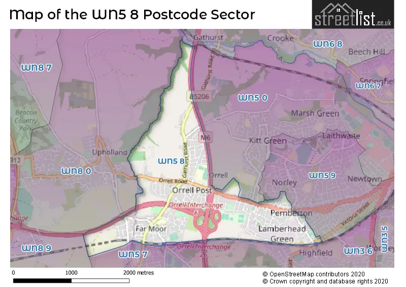
The WN5 8 Postcode shares a border with WN8 9 (SKELMERSDALE, Crawford Village, Upholland), WN5 0 (WIGAN, Orrell, Martland Park), WN5 9 (WIGAN, Newtown), WN3 6 (WIGAN, Winstanley), WN5 7 (Billinge, Orrell), WN6 8 (Shevington, WIGAN, Standish Lower Ground) and WN8 0 (Upholland, SKELMERSDALE, Roby Mill).
The sector is within the post town of WIGAN.
WN5 8 is a postcode sector within the WN5 postcode district which is within the WN Wigan postcode area.
The Royal Mail delivery office for the WN5 8 postal sector is the Wigan Delivery Office.
The area of the WN5 8 postcode sector is 1.88 square miles which is 4.87 square kilometres or 1,203.74 square acres.
The WN5 8 postcode sector is crossed by the M6 motorway.
The WN5 8 postcode sector is crossed by the M58 motorway.
Waterways within the WN5 8 postcode sector include the River Douglas.

Map of the WN5 8 Postcode Sector
Explore the WN5 8 postcode sector by using our free interactive map.
| W | N | 5 | - | 8 | X | X |
| W | N | 5 | Space | 8 | Letter | Letter |
Official List of Streets
Orrell (116 Streets)
Pemberton (13 Streets)
WIGAN (44 Streets)
Winstanley (1 Streets)
Unofficial Streets or Alternative Spellings
WIGAN
FLEET STREET LAMBERHEAD ROAD LICHFIELD STREET NORLEY HALL AVENUE BEEFORD DRIVE CROSS STREET FARRELL STREET GATHURST VIADUCT GLOUCESTER ROAD HARTLEY STREET M58 LINK MILLBECK FARM MOOR ROAD ROUNDABOUT MOSS STREET MOSS TERRACE ORRELL INTERCHANGE PIGOT STREET RIGBYS YARD THE COPSEOrrell
CHAPEL STREET OXHOUSE ROAD VICARAGE ROADBillinge
HALL LANEUpholland
SCHOOL LANE TONTINE ROADSchools and Places of Education Within the WN5 8 Postcode Sector
Orrell Holgate Academy
Academy converter
Moor Road, Wigan, Lancashire, WN5 8SJ
Head: Mrs Gail Worrall
Ofsted Rating: Good
Inspection: 2019-09-26 (1709 days ago)
Website: Visit Orrell Holgate Academy Website
Phone: 01942776670
Number of Pupils: 213
St Peter's Catholic High School
Voluntary aided school
Howards Lane, Wigan, Lancashire, WN5 8NU
Head: Mr Andrew McGlown
Ofsted Rating: Good
Inspection: 2019-02-27 (1920 days ago)
Website: Visit St Peter's Catholic High School Website
Phone: 01942747693
Number of Pupils: 1036
House Prices in the WN5 8 Postcode Sector
| Type of Property | 2018 Average | 2018 Sales | 2017 Average | 2017 Sales | 2016 Average | 2016 Sales | 2015 Average | 2015 Sales |
|---|---|---|---|---|---|---|---|---|
| Detached | £270,253 | 32 | £234,974 | 40 | £241,571 | 59 | £240,221 | 55 |
| Semi-Detached | £149,478 | 92 | £148,049 | 92 | £140,294 | 87 | £132,700 | 79 |
| Terraced | £116,115 | 52 | £110,814 | 65 | £100,722 | 55 | £105,459 | 58 |
| Flats | £113,333 | 3 | £102,917 | 6 | £79,599 | 5 | £63,875 | 4 |
Important Postcodes WN5 8 in the Postcode Sector
WN5 8NU is the postcode for MAIN BLOCK, St. Peters RC High School, Howards Lane, SPORTS HALL, St. Peters RC High School, Howards Lane, and MUSIC & DRAMA, St. Peter's RC High School, Howard's Lane
WN5 8SJ is the postcode for Orrell Holgate Primary School, Moor Road, and MAIN BUILDING, Orrell Holgate Primary School, Moor Road
| The WN5 8 Sector is within these Local Authorities |
|
|---|---|
| The WN5 8 Sector is within these Counties |
|
| The WN5 8 Sector is within these Water Company Areas |
|