The WN6 9 postcode sector stands on the Greater Manchester and Lancashire border.
Did you know? According to the 2021 Census, the WN6 9 postcode sector is home to a bustling 5,338 residents!
Given that each sector allows for 400 unique postcode combinations. Letters C, I, K, M, O and V are not allowed in the last two letters of a postcode. With 150 postcodes already in use, this leaves 250 units available.
The largest settlements in the WN6 9 postal code are Appley Bridge and Wrightington.
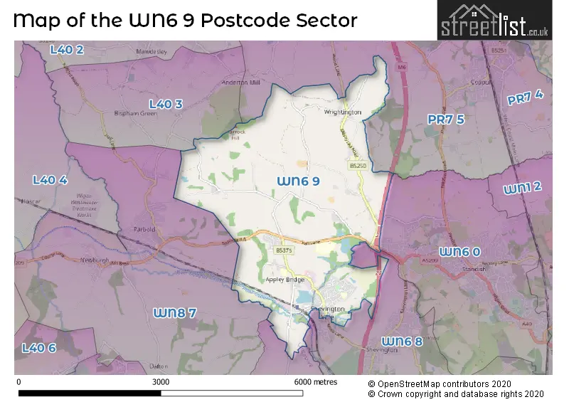
The WN6 9 Postcode shares a border with L40 3 (Mawdesley, Bispham), PR7 5 (Coppull, Eccleston, Charnock Richard), WN6 0 (Standish), WN6 8 (Shevington, WIGAN, Standish Lower Ground), WN8 0 (Upholland, SKELMERSDALE, Roby Mill) and WN8 7 (Parbold, Newburgh, Dalton).
The sector is within the post town of WIGAN.
WN6 9 is a postcode sector within the WN6 postcode district which is within the WN Wigan postcode area.
The Royal Mail delivery office for the WN6 9 postal sector is the Wigan Delivery Office.
The area of the WN6 9 postcode sector is 6.28 square miles which is 16.28 square kilometres or 4,022.35 square acres.
The WN6 9 postcode sector is crossed by the M6 motorway.
Waterways within the WN6 9 postcode sector include the River Douglas, Leeds and Liverpool Canal.

Map of the WN6 9 Postcode Sector
Explore the WN6 9 postcode sector by using our free interactive map.
| W | N | 6 | - | 9 | X | X |
| W | N | 6 | Space | 9 | Letter | Letter |
Official List of Streets
Appley Bridge (62 Streets)
Wrightington (26 Streets)
Unofficial Streets or Alternative Spellings
Wrightington
BOUNDARY LANE WRIGHTINGTON BARHeskin
BARMSKIN LANE SANDERSON LANE WOOD LANERoby Mill
BANK BROWShevington
SHELLINGFORD CLOSEDalton
LEES LANEBispham
BANNISTER LANEParbold
STONEY LANESchools and Places of Education Within the WN6 9 Postcode Sector
Fir Tree College
Special post 16 institution
The Nook, Wigan, Greater Manchester, WN6 9JB
Head: Mr Daniel Bowman
Ofsted Rating: Good
Inspection: 2022-06-17 (706 days ago)
Website: Visit Fir Tree College Website
Phone: 01257251502
Number of Pupils: 0
Shevington Vale Primary School
Community school
Runshaw Avenue, Wigan, Lancashire, WN6 9JP
Head: Mrs Karen Tomlinson
Ofsted Rating: Good
Inspection: 2022-03-02 (813 days ago)
Website: Visit Shevington Vale Primary School Website
Phone: 01257253559
Number of Pupils: 191
St Joseph's Catholic Primary School, Wrightington
Voluntary aided school
Mossy Lea Road, Wigan, Lancashire, WN6 9RE
Head: Miss Vicki Gleeson
Ofsted Rating: Good
Inspection: 2022-03-22 (793 days ago)
Website: Visit St Joseph's Catholic Primary School, Wrightington Website
Phone: 01257423092
Number of Pupils: 105
Wrightington Mossy Lea Primary School
Community school
Mossy Lea Road, Wigan, Lancashire, WN6 9RN
Head: Mr Andy Purcell
Ofsted Rating: Good
Inspection: 2019-05-01 (1849 days ago)
Website: Visit Wrightington Mossy Lea Primary School Website
Phone: 01257423107
Number of Pupils: 17
House Prices in the WN6 9 Postcode Sector
| Type of Property | 2018 Average | 2018 Sales | 2017 Average | 2017 Sales | 2016 Average | 2016 Sales | 2015 Average | 2015 Sales |
|---|---|---|---|---|---|---|---|---|
| Detached | £290,556 | 26 | £336,629 | 29 | £281,097 | 46 | £279,161 | 40 |
| Semi-Detached | £191,705 | 36 | £192,271 | 26 | £165,355 | 30 | £168,876 | 37 |
| Terraced | £180,333 | 9 | £160,521 | 12 | £136,896 | 12 | £157,612 | 17 |
| Flats | £121,250 | 2 | £169,975 | 2 | £0 | 0 | £112,000 | 2 |
Important Postcodes WN6 9 in the Postcode Sector
WN6 9DT is the postcode for ALL SAINTS CHURCH, FINCH LANE, APPLEY BRIDGE, and All Saints C of E Primary School, Finch Lane
WN6 9EP is the postcode for WARDS 1-7 OPERATING THEATRE AND LABORATORIES BLOCKS 5-13 AND 15, Wrightington, Wigan and Leigh NHS Trust, Wrightington Hospital, ASSISTED CONCEPTION UNIT, Wrightington, Wigan and Leigh NHS Trust, Wrightington Hospital, WARDS D-E AND ANCILLIARY BUILDINGS BLOCKS 16,23-30 AND 32-36, Wrightington, Wigan and Leigh NHS Trust, Wrightington Hospital, MODULAR THEATRE TEN, Wrightington, Wigan and Leigh NHS Trust, Wrightington Hospital, Wrightington, Wigan and Leigh NHS Trust, Wrightington Hospital, ADMINISTRATION BUILDING, Wrightington, Wigan and Leigh NHS Trust, Wrightington Hospital, Wards 1-7, Operating Theatre and Labratories Blocks 5-13 and 15, Wrightington, Wigan and Leigh NHS Trust, Wrightington Hospital, and CONFERENCE CENTRE BLOCK 39, Wrightington, Wigan and Leigh NHS Trust, Wrightington Hospital
WN6 9JP is the postcode for Shevington Vale Cp School, Runshaw Avenue, and Shevington Vale Cp School, Runshaw Avenue, Appley Bridge
WN6 9RE is the postcode for St Josephs Catholic Primary School, Mossy Lea Road, and St. Josephs RC School, 107 Mossy Lea Road
WN6 9RN is the postcode for Mossy Lea Primary School, Mossy Lea Road
| The WN6 9 Sector is within these Local Authorities |
|
|---|---|
| The WN6 9 Sector is within these Counties |
|
| The WN6 9 Sector is within these Water Company Areas |
|