The WR3 8 postcode sector is within the county of Worcestershire.
Did you know? According to the 2021 Census, the WR3 8 postcode sector is home to a bustling 9,719 residents!
Given that each sector allows for 400 unique postcode combinations. Letters C, I, K, M, O and V are not allowed in the last two letters of a postcode. With 237 postcodes already in use, this leaves 163 units available.
The largest settlement in the WR3 8 postal code is WORCESTER followed by Fernhill Heath, and Hindlip.
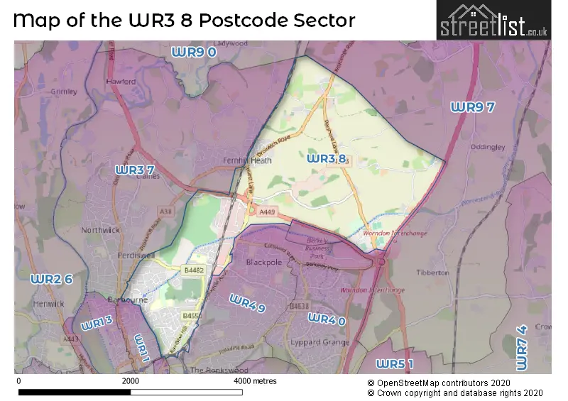
The WR3 8 Postcode shares a border with WR9 0 (Ombersley, DROITWICH, Hampton Lovett), WR9 7 (DROITWICH, Wychbold, Copcut), WR1 1 (WORCESTER), WR1 2 (WORCESTER), WR3 7 (WORCESTER, Fernhill Heath, Claines), WR4 0 (WORCESTER, Lyppard Hanford, Long Meadow) and WR4 9 (WORCESTER, Warndon).
The sector is within the post town of WORCESTER.
WR3 8 is a postcode sector within the WR3 postcode district which is within the WR Worcester postcode area.
The Royal Mail delivery office for the WR3 8 postal sector is the Worcester City Delivery Office and Worcester Apc.
The area of the WR3 8 postcode sector is 4.23 square miles which is 10.94 square kilometres or 2,704.09 square acres.
The WR3 8 postcode sector is crossed by the M5 motorway.
Waterways within the WR3 8 postcode sector include the Worcester & Birmingham Canal.

Map of the WR3 8 Postcode Sector
Explore the WR3 8 postcode sector by using our free interactive map.
| W | R | 3 | - | 8 | X | X |
| W | R | 3 | Space | 8 | Letter | Letter |
Official List of Streets
WORCESTER (110 Streets)
Fernhill Heath (20 Streets)
Martin Hussingtree (6 Streets)
Unofficial Streets or Alternative Spellings
Oddingley
GREEN LANENewland
BROWN HEATH LANECopcut
WORCESTER ROADFernhill Heath
STATION ROADWORCESTER
BRICKFIELDS ROAD SUNNYSIDE ROADClaines
DROITWICH ROADSchools and Places of Education Within the WR3 8 Postcode Sector
Bishop Perowne CofE College
Academy converter
Merriman's Hill Road, Worcester, Worcestershire, WR3 8LE
Head: Mrs Jane Price
Ofsted Rating: Good
Inspection: 2018-10-17 (2045 days ago)
Website: Visit Bishop Perowne CofE College Website
Phone: 01905746800
Number of Pupils: 1026
Hindlip CofE First School
Voluntary controlled school
Droitwich Road, Worcester, Worcestershire, WR3 8RJ
Head: Mr Alex Gromski
Ofsted Rating: Outstanding
Inspection: 2012-06-21 (4354 days ago)
Website: Visit Hindlip CofE First School Website
Phone: 01905453455
Number of Pupils: 87
St Barnabas CofE Primary School
Voluntary controlled school
Green Lane, Worcester, Worcestershire, WR3 8NZ
Head: Mrs Sarah Hanson
Ofsted Rating: Good
Inspection: 2023-04-26 (393 days ago)
Website: Visit St Barnabas CofE Primary School Website
Phone: 0190522766
Number of Pupils: 408
Tudor Grange Academy Worcester
Academy sponsor led
Bilford Road, Worcester, Worcestershire, WR3 8HN
Head: Mr David Butler
Ofsted Rating: Good
Inspection: 2019-05-22 (1828 days ago)
Website: Visit Tudor Grange Academy Worcester Website
Phone: 01905454627
Number of Pupils: 1122
House Prices in the WR3 8 Postcode Sector
| Type of Property | 2018 Average | 2018 Sales | 2017 Average | 2017 Sales | 2016 Average | 2016 Sales | 2015 Average | 2015 Sales |
|---|---|---|---|---|---|---|---|---|
| Detached | £344,060 | 42 | £351,126 | 39 | £307,201 | 58 | £308,719 | 43 |
| Semi-Detached | £220,514 | 58 | £206,471 | 43 | £189,725 | 70 | £201,825 | 60 |
| Terraced | £192,974 | 81 | £174,273 | 79 | £160,204 | 91 | £168,133 | 72 |
| Flats | £151,668 | 24 | £116,806 | 27 | £120,828 | 26 | £120,022 | 23 |
Important Postcodes WR3 8 in the Postcode Sector
WR3 8BP is the postcode for Heart of Worcester College, Unit 12, Northbrook Close
WR3 8DX is the postcode for Perdiswell Leisure Centre, Bilford Road
WR3 8HN is the postcode for SPORTS HALL, Elgar Technology College, Bilford Road, Tudor Grange Academy, Bilford Road, and Elgar Technology College, Bilford Road
WR3 8LE is the postcode for GYM & SPORTS HALL BISHOP PEROWNE C OF E COLLEGE, Bishop Perowne C of E College, Merrimans Hill Road, MALVERN LEARNING CENTRE BISHOP PEROWNE C OF E COLLEGE, Bishop Perowne C of E College, Merrimans Hill Road, CLENT HOUSE BISHOP PEROWNE C OF E COLLEGE, Bishop Perowne C of E College, Merrimans Hill Road, Bishop Perowne C of E College, Merrimans Hill Road, LICKEY BISHOP PEROWNE C OF E COLLEGE, Bishop Perowne C of E College, Merrimans Hill Road, BREDON BISHOP PEROWNE C OF E COLLEGE, Bishop Perowne C of E College, Merrimans Hill Road, and ABBERLEY BISHOP PEROWNE C OF E COLLEGE, Bishop Perowne C of E College, Merrimans Hill Road
WR3 8NZ is the postcode for ST BARNABAS CE PRIMARY SCHOOL, GREEN LANE, WORCESTER, and St. Barnabas CE Primary School, Green Lane
WR3 8PU is the postcode for The Pines, Bilford Road
WR3 8QA is the postcode for Perdiswell Primary School, Bilford Road
WR3 8SP is the postcode for West Mercia Police, Traffic/Radio Workshop/Supplies, West Mercia Police, Training School, West Mercia Police, Firearms Range, West Mercia Police, Accommodation Block, West Mercia Police, Jacky Smith Training Centre, West Mercia Police - Headquarters, Hindlip Hall, West Mercia Police, Sports and Social Centre, West Mercia Police, Catering and Lecture Hall, West Mercia Police, Scientific Support/CID, and SPORTS HALL, West Mercia Police - Headquarters, Hindlip Hall
| The WR3 8 Sector is within these Local Authorities |
|
|---|---|
| The WR3 8 Sector is within these Counties |
|
| The WR3 8 Sector is within these Water Company Areas |
|