The WR6 5 postcode sector stands on the Herefordshire and Worcestershire border.
Did you know? According to the 2021 Census, the WR6 5 postcode sector is home to a bustling 5,363 residents!
Given that each sector allows for 400 unique postcode combinations. Letters C, I, K, M, O and V are not allowed in the last two letters of a postcode. With 228 postcodes already in use, this leaves 172 units available.
The largest settlement in the WR6 5 postal code is Whitbourne followed by Bishops Frome, and Suckley.
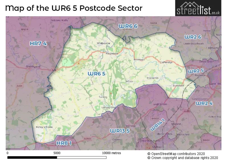
The WR6 5 Postcode shares a border with WR13 5 (Cradley, Leigh Sinton, Newland), WR2 4 (WORCESTER, Powick, Callow End), WR2 5 (WORCESTER, Rushwick), WR2 6 (WORCESTER, Hallow, Lower Broadheath), WR6 6 (Martley, Clifton-on-Teme, Holt Heath), HR7 4 (BROMYARD, Tedstone Wafre, Stoke Lacy) and HR8 1 (LEDBURY, Bosbury, Wellington Heath).
The sector is within the post town of WORCESTER.
WR6 5 is a postcode sector within the WR6 postcode district which is within the WR Worcester postcode area.
The Royal Mail delivery office for the WR6 5 postal sector is the Broadwas Scale Payment Delivery Office and Alfrick Scale Payment Delivery Office and Bishops Frome Scale Payment Delivery Office and Bringsty Scale Payment Delivery Office and Suckley Scale Payment Delivery Office and Worcester Apc.
The area of the WR6 5 postcode sector is 41.18 square miles which is 106.66 square kilometres or 26,356.21 square acres.
Waterways within the WR6 5 postcode sector include the River Teme.

Map of the WR6 5 Postcode Sector
Explore the WR6 5 postcode sector by using our free interactive map.
| W | R | 6 | - | 5 | X | X |
| W | R | 6 | Space | 5 | Letter | Letter |
Official List of Streets
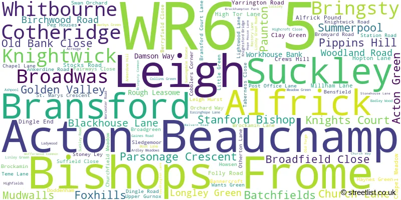
Whitbourne (15 Streets)
Acton Beauchamp (2 Streets)
Alfrick (18 Streets)
Knightwick (10 Streets)
Cotheridge (6 Streets)
Bishops Frome (9 Streets)
Leigh (7 Streets)
Broadwas (15 Streets)
Suckley (7 Streets)
Bransford (7 Streets)
Bringsty (6 Streets)
Unofficial Streets or Alternative Spellings
Lower Broadheath
FRENCHLANDS LANEMartley
WILLOW ROADAvenbury
AVENBURY LANESchools and Places of Education Within the WR6 5 Postcode Sector
Broadwas CofE Aided Primary School
Voluntary aided school
Broadwas, Worcester, Worcestershire, WR6 5NE
Head: Mr James Dennis
Ofsted Rating: Good
Inspection: 2021-09-15 (981 days ago)
Website: Visit Broadwas CofE Aided Primary School Website
Phone: 01886821347
Number of Pupils: 87
Brockhampton Primary School
Academy converter
Brockhampton, Bromyard, Herefordshire, WR6 5TD
Head: Mr Matthew Mander
Ofsted Rating: Good
Inspection: 2022-10-19 (582 days ago)
Website: Visit Brockhampton Primary School Website
Phone: 01885483238
Number of Pupils: 202
Hidelow Grange School
Other independent school
Hidelow House, Acton Beauchamp, , WR6 5AH
Head: Mr Sam Goodchild
Ofsted Rating: Good
Inspection: 2021-12-09 (896 days ago)
Website: Visit Hidelow Grange School Website
Phone: 01886884832
Number of Pupils: 7
Our Place School
Other independent special school
The Orchard, Bransford, Worcestershire, WR6 5JE
Head: Mrs Lauren Tallis
Ofsted Rating: Good
Inspection: 2021-07-01 (1057 days ago)
Website: Visit Our Place School Website
Phone: 01886833378
Number of Pupils: 12
Suckley Primary School
Academy converter
Church Lane, Worcester, Worcestershire, WR6 5DE
Head: Mrs Helen Field
Ofsted Rating: Outstanding
Inspection: 2014-01-31 (3765 days ago)
Website: Visit Suckley Primary School Website
Phone: 01886884283
Number of Pupils: 86
House Prices in the WR6 5 Postcode Sector
| Type of Property | 2018 Average | 2018 Sales | 2017 Average | 2017 Sales | 2016 Average | 2016 Sales | 2015 Average | 2015 Sales |
|---|---|---|---|---|---|---|---|---|
| Detached | £418,131 | 40 | £384,270 | 52 | £381,296 | 48 | £436,583 | 39 |
| Semi-Detached | £271,288 | 12 | £227,022 | 23 | £238,435 | 32 | £236,783 | 12 |
| Terraced | £223,167 | 6 | £195,795 | 15 | £198,679 | 7 | £143,038 | 12 |
| Flats | £172,238 | 4 | £161,900 | 5 | £270,000 | 1 | £139,663 | 4 |
Important Postcodes WR6 5 in the Postcode Sector
WR6 5DE is the postcode for Suckley School, Church Lane
WR6 5NE is the postcode for Broadwas School, Broadwas
WR6 5TD is the postcode for Brockhampton School, Brockhampton, Bringsty
| The WR6 5 Sector is within these Local Authorities |
|
|---|---|
| The WR6 5 Sector is within these Counties |
|
| The WR6 5 Sector is within these Water Company Areas |
|
Tourist Attractions within the WR6 5 Postcode Area
We found 1 visitor attractions within the WR6 postcode area
| Brockhampton Estate |
|---|
| Historic Properties |
| Historic House / House and Garden / Palace |
| View Brockhampton Estate on Google Maps |