The YO61 4 postcode sector is within the county of North Yorkshire.
Did you know? According to the 2021 Census, the YO61 4 postcode sector is home to a bustling 2,048 residents!
Given that each sector allows for 400 unique postcode combinations. Letters C, I, K, M, O and V are not allowed in the last two letters of a postcode. With 110 postcodes already in use, this leaves 290 units available.
The largest settlement in the YO61 4 postal code is Husthwaite followed by Brandsby, and Crayke.
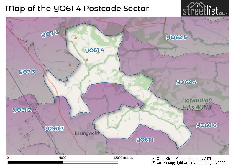
The YO61 4 Postcode shares a border with YO7 2 (Bagby, Sutton, South Kilvington), YO7 3 (Sowerby, THIRSK, Dalton), YO60 6 (Sheriff Hutton, Terrington, Lilling), YO61 1 (Sutton-on-the-Forest, Huby, Tollerton), YO61 3 (Easingwold, Raskelf, Oulston) and YO62 4 (Slingsby, Ampleforth, Hovingham).
The sector is within the post town of YORK.
YO61 4 is a postcode sector within the YO61 postcode district which is within the YO York postcode area.
The Royal Mail delivery office for the YO61 4 postal sector is the Thirsk Delivery Office.
The area of the YO61 4 postcode sector is 32.13 square miles which is 83.21 square kilometres or 20,562.20 square acres.
Waterways within the YO61 4 postcode sector include the Holbeck, River Kyle, Elphin Beck, Long Beck.

Map of the YO61 4 Postcode Sector
Explore the YO61 4 postcode sector by using our free interactive map.
| Y | O | 6 | 1 | - | 4 | X | X |
| Y | O | 6 | 1 | Space | 4 | Letter | Letter |
Official List of Streets
Crayke (9 Streets)
Coxwold (5 Streets)
Brandsby (10 Streets)
Husthwaite (8 Streets)
Kilburn (3 Streets)
Wass (2 Streets)
Thormanby (1 Streets)
Oldstead (1 Streets)
Whenby (1 Streets)
Schools and Places of Education Within the YO61 4 Postcode Sector
Crayke Church of England Voluntary Controlled Primary School
Voluntary controlled school
Easingwold Road, YORK, North Yorkshire, YO61 4TZ
Head: Mrs Judi Jackson
Ofsted Rating: Outstanding
Inspection: 2012-10-24 (4232 days ago)
Website: Visit Crayke Church of England Voluntary Controlled Primary School Website
Phone: 01347821767
Number of Pupils: 94
Husthwaite Church of England Voluntary Controlled Primary School
Voluntary controlled school
Low Street, York, North Yorkshire, YO61 4QA
Head: Miss Fiona Bennett
Ofsted Rating: Requires improvement
Inspection: 2022-10-12 (592 days ago)
Website: Visit Husthwaite Church of England Voluntary Controlled Primary School Website
Phone: 01347868371
Number of Pupils: 68
House Prices in the YO61 4 Postcode Sector
| Type of Property | 2018 Average | 2018 Sales | 2017 Average | 2017 Sales | 2016 Average | 2016 Sales | 2015 Average | 2015 Sales |
|---|---|---|---|---|---|---|---|---|
| Detached | £430,563 | 8 | £762,603 | 19 | £468,643 | 14 | £487,436 | 14 |
| Semi-Detached | £216,757 | 7 | £344,988 | 4 | £356,250 | 4 | £245,090 | 5 |
| Terraced | £350,300 | 5 | £377,520 | 5 | £294,000 | 4 | £230,667 | 6 |
| Flats | £0 | 0 | £0 | 0 | £0 | 0 | £0 | 0 |
Important Postcodes YO61 4 in the Postcode Sector
YO61 4QA is the postcode for Husthwaite Church Of England Vc Primary School, Low Street, and MAIN BUILDING, Husthwaite C of E Primary School, Low Street
YO61 4TZ is the postcode for Crayke C of E Primary School, Easingwold Road, Crayke
| The YO61 4 Sector is within these Local Authorities |
|
|---|---|
| The YO61 4 Sector is within these Counties |
|
| The YO61 4 Sector is within these Water Company Areas |
|
Tourist Attractions within the YO61 4 Postcode Area
We found 1 visitor attractions within the YO61 postcode area
| Byland Abbey |
|---|
| Historic Properties |
| Historic Monument / Archaeological Site |
| View Byland Abbey on Google Maps |