The B11 2 postcode sector is within the county of West Midlands.
Did you know? According to the 2021 Census, the B11 2 postcode sector is home to a bustling 4,331 residents!
Given that each sector allows for 400 unique postcode combinations. Letters C, I, K, M, O and V are not allowed in the last two letters of a postcode. With 102 postcodes already in use, this leaves 298 units available.
The largest settlement in the B11 2 postal code is BIRMINGHAM followed by Tyseley, and Sparkbrook.
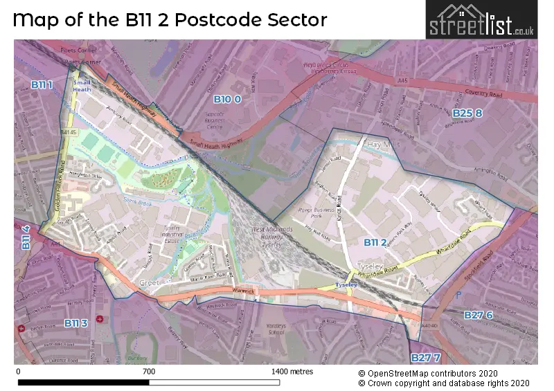
The B11 2 Postcode shares a border with B11 1 (BIRMINGHAM, Sparkhill, Sparkbrook), B10 0 (BIRMINGHAM, Small Heath), B11 3 (BIRMINGHAM, Sparkhill, Tyseley), B11 4 (Sparkhill, BIRMINGHAM), B27 6 (Acocks Green, BIRMINGHAM), B25 8 (BIRMINGHAM, Yardley) and B27 7 (BIRMINGHAM, Acocks Green).
The sector is within the post town of BIRMINGHAM.
B11 2 is a postcode sector within the B1 postcode district which is within the B Birmingham postcode area.
The Royal Mail delivery office for the B11 2 postal sector is the Birmingham Central Delivery Office.
The area of the B11 2 postcode sector is 0.72 square miles which is 1.86 square kilometres or 458.81 square acres.
Waterways within the B11 2 postcode sector include the River Cole, Grand Union Canal.

Map of the B11 2 Postcode Sector
Explore the B11 2 postcode sector by using our free interactive map.
| B | 1 | 1 | - | 2 | X | X |
| B | 1 | 1 | Space | 2 | Letter | Letter |
Official List of Streets
Sparkhill (2 Streets)
BIRMINGHAM (26 Streets)
New Shires Industrial Estate (1 Streets)
Sparkbrook (1 Streets)
Greet (2 Streets)
Tyseley (5 Streets)
Unofficial Streets or Alternative Spellings
BIRMINGHAM
ANDERTON ROAD BARROWS ROAD BENTON ROAD BOSCOMBE ROAD BYRON ROAD KNIGHTS ROAD MALMESBURY ROAD MEDINA ROAD NINFIELD ROAD OLDKNOW ROAD PERCY ROAD SMALL HEATH HIGHWAY TENNYSON ROAD TYSELEY LANE WALFORD ROAD WAVERLEY ROAD WESTON LANETyseley
WHARFDALE ROAD BLYTHSWOOD COURT POETS CORNER SMALL HEATH TRADING ESTATE WHARFEDALE ROADHall Green
REDDINGS LANEAcocks Green
WARWICK ROADNew Shires Industrial Estate
SYDENHAM ROADSparkbrook
ANSELL ROADSchools and Places of Education Within the B11 2 Postcode Sector
Ark Boulton Academy
Academy sponsor led
Golden Hillock Road, Birmingham, West Midlands, B11 2QG
Head: Mr Laurence Cole
Ofsted Rating: Good
Inspection: 2022-07-06 (687 days ago)
Website: Visit Ark Boulton Academy Website
Phone: 01217738156
Number of Pupils: 910
House Prices in the B11 2 Postcode Sector
| Type of Property | 2018 Average | 2018 Sales | 2017 Average | 2017 Sales | 2016 Average | 2016 Sales | 2015 Average | 2015 Sales |
|---|---|---|---|---|---|---|---|---|
| Detached | £0 | 0 | £0 | 0 | £0 | 0 | £0 | 0 |
| Semi-Detached | £160,500 | 4 | £150,500 | 4 | £158,600 | 5 | £119,667 | 3 |
| Terraced | £115,382 | 48 | £111,301 | 30 | £102,967 | 33 | £94,811 | 37 |
| Flats | £60,672 | 5 | £54,500 | 2 | £146,333 | 3 | £0 | 0 |
Important Postcodes B11 2 in the Postcode Sector
B11 2AB is the postcode for Birmingham City Council, Redfern Depot, Kings Road
B11 2DY is the postcode for Royal Mail, Redfern Park Delivery Office, Wharfdale Road
B11 2QG is the postcode for A, D, E Blocks, Ark Boulton Academy, Golden Hillock Road, Ark Boulton Academy, Golden Hillock Road, and B & C Blocks, Ark Boulton Academy, Golden Hillock Road
| The B11 2 Sector is within these Local Authorities |
|
|---|---|
| The B11 2 Sector is within these Counties |
|
| The B11 2 Sector is within these Water Company Areas |
|