The B20 2 postcode sector is within the county of West Midlands.
Did you know? According to the 2021 Census, the B20 2 postcode sector is home to a bustling 12,215 residents!
Given that each sector allows for 400 unique postcode combinations. Letters C, I, K, M, O and V are not allowed in the last two letters of a postcode. With 194 postcodes already in use, this leaves 206 units available.
The largest settlements in the B20 2 postal code are BIRMINGHAM and Handsworth.
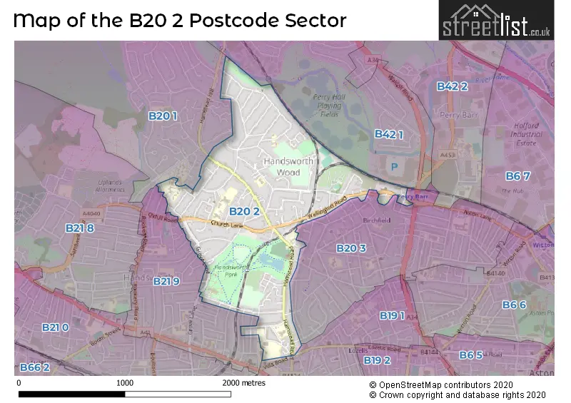
The B20 2 Postcode shares a border with B20 1 (BIRMINGHAM), B19 1 (BIRMINGHAM, Lozells, Handsworth), B20 3 (BIRMINGHAM, Handsworth), B21 9 (Handsworth, BIRMINGHAM) and B42 1 (BIRMINGHAM, Perry Barr, Great Barr).
The sector is within the post town of BIRMINGHAM.
B20 2 is a postcode sector within the B20 postcode district which is within the B Birmingham postcode area.
The Royal Mail delivery office for the B20 2 postal sector is the Handsworth Delivery Office.
The area of the B20 2 postcode sector is 0.97 square miles which is 2.51 square kilometres or 621.13 square acres.
Waterways within the B20 2 postcode sector include the River Tame.

Map of the B20 2 Postcode Sector
Explore the B20 2 postcode sector by using our free interactive map.
| B | 2 | 0 | - | 2 | X | X |
| B | 2 | 0 | Space | 2 | Letter | Letter |
Official List of Streets
BIRMINGHAM (66 Streets)
Handsworth (22 Streets)
Unofficial Streets or Alternative Spellings
Handsworth
ALBERT ROAD BRUNSWICK ROAD DOUGLAS ROAD HERBERT ROAD LANSDOWNE ROAD LESLIE ROAD MANWOODS CLOSE THORNHILL ROAD WESTMINSTER ROAD WHITEHALL ROAD WINDERMERE ROAD YORK ROADBIRMINGHAM
ANTROBUS ROAD BETT ROAD CHURCH HILL ROAD ENGLESTEDE CLOSE GIBSON ROAD GROVE HILL ROAD KINGSLEIGH ROAD LOFTHOUSE ROAD MAXWELL AVENUE OXHILL ROAD RADNOR ROAD UPPER GROSVENOR ROAD WELLESBOURNE ROAD WILLMORE ROAD BUTLERS COURT LANE COLLEGE GROVE DOROTHY GARDENS EQUIANO CLOSE HILL GROVE RICHMOND CLOSE ST ANNES CLOSE TAME VALLEY WAY WOOD COURTWeather Forecast for B20 2
Press Button to Show Forecast for Brown's Green
| Time Period | Icon | Description | Temperature | Rain Probability | Wind |
|---|---|---|---|---|---|
| 00:00 to 03:00 | Cloudy | 5.0°C (feels like 3.0°C) | 8.00% | E 7 mph | |
| 03:00 to 06:00 | Cloudy | 4.0°C (feels like 2.0°C) | 9.00% | E 4 mph | |
| 06:00 to 09:00 | Cloudy | 4.0°C (feels like 2.0°C) | 5.00% | ENE 4 mph | |
| 09:00 to 12:00 | Cloudy | 6.0°C (feels like 4.0°C) | 5.00% | ENE 7 mph | |
| 12:00 to 15:00 | Overcast | 9.0°C (feels like 7.0°C) | 10.00% | ENE 4 mph | |
| 15:00 to 18:00 | Overcast | 10.0°C (feels like 8.0°C) | 11.00% | ENE 4 mph | |
| 18:00 to 21:00 | Cloudy | 9.0°C (feels like 7.0°C) | 9.00% | ENE 7 mph | |
| 21:00 to 00:00 | Partly cloudy (night) | 7.0°C (feels like 4.0°C) | 8.00% | E 7 mph |
Press Button to Show Forecast for Brown's Green
| Time Period | Icon | Description | Temperature | Rain Probability | Wind |
|---|---|---|---|---|---|
| 00:00 to 03:00 | Cloudy | 5.0°C (feels like 2.0°C) | 12.00% | ENE 7 mph | |
| 03:00 to 06:00 | Cloudy | 4.0°C (feels like 2.0°C) | 12.00% | ENE 7 mph | |
| 06:00 to 09:00 | Cloudy | 4.0°C (feels like 2.0°C) | 13.00% | ENE 7 mph | |
| 09:00 to 12:00 | Cloudy | 7.0°C (feels like 4.0°C) | 17.00% | ENE 9 mph | |
| 12:00 to 15:00 | Overcast | 9.0°C (feels like 6.0°C) | 25.00% | ENE 9 mph | |
| 15:00 to 18:00 | Light rain | 10.0°C (feels like 7.0°C) | 49.00% | ENE 9 mph | |
| 18:00 to 21:00 | Cloudy | 9.0°C (feels like 7.0°C) | 19.00% | ENE 9 mph | |
| 21:00 to 00:00 | Cloudy | 8.0°C (feels like 5.0°C) | 21.00% | NE 9 mph |
Press Button to Show Forecast for Brown's Green
| Time Period | Icon | Description | Temperature | Rain Probability | Wind |
|---|---|---|---|---|---|
| 00:00 to 03:00 | Light rain | 7.0°C (feels like 4.0°C) | 49.00% | NE 9 mph | |
| 03:00 to 06:00 | Light rain | 6.0°C (feels like 4.0°C) | 53.00% | NE 9 mph | |
| 06:00 to 09:00 | Heavy rain | 7.0°C (feels like 4.0°C) | 73.00% | NE 9 mph | |
| 09:00 to 12:00 | Heavy rain | 8.0°C (feels like 6.0°C) | 76.00% | NNE 9 mph | |
| 12:00 to 15:00 | Light rain shower (day) | 10.0°C (feels like 8.0°C) | 44.00% | NNW 9 mph | |
| 15:00 to 18:00 | Light rain | 11.0°C (feels like 9.0°C) | 54.00% | NW 9 mph | |
| 18:00 to 21:00 | Heavy rain shower (day) | 10.0°C (feels like 8.0°C) | 55.00% | WSW 9 mph | |
| 21:00 to 00:00 | Partly cloudy (night) | 9.0°C (feels like 7.0°C) | 11.00% | SW 7 mph |
Schools and Places of Education Within the B20 2 Postcode Sector
Cherry Orchard Primary School
Community school
Cherry Orchard Road, Birmingham, West Midlands, B20 2LB
Head: Miss Alison Taylor
Ofsted Rating: Good
Inspection: 2023-03-29 (394 days ago)
Website: Visit Cherry Orchard Primary School Website
Phone: 01215540862
Number of Pupils: 467
King Edward VI Handsworth Wood Girls' Academy
Academy converter
Church Lane, Birmingham, West Midlands, B20 2HL
Head: Mr Qamar Riaz
Ofsted Rating: Outstanding
Inspection: 2014-05-23 (3626 days ago)
Website: Visit King Edward VI Handsworth Wood Girls' Academy Website
Phone: 01215548122
Number of Pupils: 1014
St Marys C of E Primary and Nursery, Academy, Handsworth
Academy converter
Hamstead Road, Birmingham, West Midlands, B20 2RW
Head: Mrs Jo Booker
Ofsted Rating: Good
Inspection: 2023-11-29 (149 days ago)
Website: Visit St Marys C of E Primary and Nursery, Academy, Handsworth Website
Phone: 01215543751
Number of Pupils: 421
St Teresa's Catholic Primary School
Voluntary aided school
Butlers Road, Birmingham, West Midlands, B20 2NY
Head: Mr Declan Corkery
Ofsted Rating: Good
Inspection: 2020-02-12 (1535 days ago)
Website: Visit St Teresa's Catholic Primary School Website
Phone: 01215549581
Number of Pupils: 210
Welford Primary School
Community school
Welford Road, Birmingham, West Midlands, B20 2BL
Head: Mrs Carol Foster
Ofsted Rating: Good
Inspection: 2019-07-10 (1752 days ago)
Website: Visit Welford Primary School Website
Phone: 01214649228
Number of Pupils: 443
House Prices in the B20 2 Postcode Sector
| Type of Property | 2018 Average | 2018 Sales | 2017 Average | 2017 Sales | 2016 Average | 2016 Sales | 2015 Average | 2015 Sales |
|---|---|---|---|---|---|---|---|---|
| Detached | £283,885 | 13 | £274,125 | 8 | £267,962 | 13 | £266,192 | 13 |
| Semi-Detached | £241,484 | 32 | £227,033 | 24 | £199,726 | 32 | £196,825 | 30 |
| Terraced | £151,437 | 59 | £160,470 | 43 | £162,206 | 41 | £136,320 | 28 |
| Flats | £78,333 | 15 | £63,289 | 19 | £75,500 | 8 | £62,813 | 23 |
Important Postcodes B20 2 in the Postcode Sector
B20 2BL is the postcode for Welford Primary School, Welford Road
B20 2BY is the postcode for Handsworth Wellbeing Centre, Holly Road, Handsworth, Play Centre, Handsworth Wellbeing Centre, Holly Road, and Handsworth Wellbeing Centre, Holly Road
B20 2HL is the postcode for ANNEX, Handsworth Wood Girls Academy, Church Lane, ANNEX, King Edward VI Handsworth Wood GirlsG�� Academy, Church Lane, King Edward VI Handsworth Wood GirlsG�� Academy, Church Lane, MAIN BUILDING, King Edward VI Handsworth Wood GirlsG�� Academy, Church Lane, and MAIN BUILDING, Handsworth Wood Girls Academy, Church Lane
B20 2LB is the postcode for JUNIOR BLOCK, Cherry Orchard Primary School, Cherry Orchard Road, INFANTS BLOCK, Cherry Orchard Primary School, Cherry Orchard Road, and Cherry Orchard Primary School, Cherry Orchard Road
B20 2NY is the postcode for St. Teresas RC School, Butlers Road
B20 2RW is the postcode for St Mary's C of E Primary School, Hamstead Road, and St Marys C Of E Primary Academy and Nursery, Hamstead Road, Handsworth
| The B20 2 Sector is within these Local Authorities |
|
|---|---|
| The B20 2 Sector is within these Counties |
|
| The B20 2 Sector is within these Water Company Areas |
|